Skip to search
Skip to main content
Skip to first result
Search
You Searched For
Extent of Digitization
Completely digitized
Format
cartographic
Language
English
Creator
United States. General Land Office
New Search
Search Results
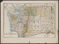
Creator:
Published / Created:
1905
Call Number:
847 1905
Container / Volume:
BRBL_00625
Image Count:
1
Resource Type:
Maps, Atlases & Globes
Description:
Includes township diagram., Prime meridians: Greenwich and Washington., and Relief shown by shading and spot heights.
Publisher:
General Land Office,
Subject (Geographic):
Washington (State)--Maps
Subject (Name):
Bauman, Wm. (William) and O'Hare, Daniel
Found in:
Beinecke Rare Book and Manuscript Library > State of Washington / compiled from the official records of the General Land Office and other sources, under the direction of Frank Bond, chief of drafting division, G.L.O. ; compiled and drawn by Daniel O'Hare ; lettering by Wm. Bauman jr.
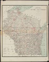
Creator:
Published / Created:
1878
Call Number:
812 1878
Container / Volume:
BRBL_00555
Image Count:
1
Resource Type:
Maps, Atlases & Globes
Description:
Prime meridans: Greenwich and Washington. and Shows drainage, county boundaries, railroads, railroad grants, Indian reservations, townships, etc.
Publisher:
General Land Office ; and Photo lith & print. by Julius Bien,
Subject (Geographic):
Wisconsin--Maps and Wisconsin--Surveys--Maps
Subject (Name):
Bien, Julius, 1826-1909, Roeser, C. (Charles), and Williamson, James A. (James Alexander), 1829-1902
Found in:
Beinecke Rare Book and Manuscript Library > State of Wisconsin / Department of the Interior, General Land Office, J.A. Williamson, commissioner ; compiled from the official records of the General Land Office and other sources by C. Roeser, Principal Draughtsman, G.L.O.
Creator:
Published / Created:
1901
Call Number:
842 1901
Container / Volume:
BRBL_00599
Image Count:
1
Resource Type:
Maps, Atlases & Globes
Description:
Prime meridians: Greenwich and Washington., Relief shown by shading., and Shows counties, Indian, military, and forest reservations, private claims, and townships.
Publisher:
General Land Office,
Subject (Geographic):
Arizona--Administrative and political divisions--Maps and Arizona--Maps
Subject (Topic):
Forest reserves--Arizona--Maps and Indian reservations--Arizona--Maps
Found in:
Beinecke Rare Book and Manuscript Library > Territory of Arizona / compiled from the official records of the General Land Office and other sources under the direction of Harry King, C.E.
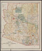
Creator:
Published / Created:
1902
Call Number:
842 1902
Container / Volume:
BRBL_00599
Image Count:
1
Resource Type:
Maps, Atlases & Globes
Description:
Prime meridians: Greenwich and Washington., Relief shown by shading., and Shows counties, Indian, military, and forest reservations, private claims, and townships.
Publisher:
The Office,
Subject (Geographic):
Arizona--Administrative and political divisions--Maps and Arizona--Maps
Subject (Topic):
Forest reserves--Arizona--Maps and Indian reservations--Arizona--Maps
Found in:
Beinecke Rare Book and Manuscript Library > Territory of Arizona / compiled from the official records of the General Land Office and other sources under the direction of Harry King, C.E.
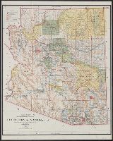
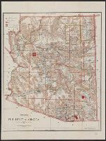
Creator:
Published / Created:
1896
Call Number:
842 1896
Container / Volume:
BRBL_00598
Image Count:
1
Resource Type:
Maps, Atlases & Globes
Description:
Prime meridians: Greenwich and Washington., Relief shown by shading., and Shows counties, Indian, military, and forest reservations, private claims, and townships.
Publisher:
General Land Office,
Subject (Geographic):
Arizona--Administrative and political divisions--Maps and Arizona--Maps
Subject (Name):
Hendges, M, Morton, Robert H, Norris Peters Co, and Towson, R. M
Subject (Topic):
Forest reserves--Arizona--Maps and Indian reservations--Arizona--Maps
Found in:
Beinecke Rare Book and Manuscript Library > Territory of Arizona / revised and reconstructed by R.H. Morton ; compiled from the official records of the General Land Office and other sources under supervision of Harry King, C.E. ; lettered by M. Hendges and R.M. Towson.
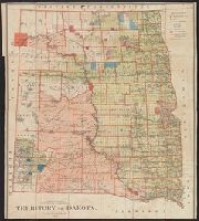
Creator:
Published / Created:
1882
Call Number:
821 1882
Container / Volume:
BRBL_00566
Image Count:
1
Resource Type:
Maps, Atlases & Globes
Description:
"N.C. McFarland, Commissioner.", Relief shown by hachures., and Shows Indian and military reservations.
Publisher:
General Land Office,
Subject (Geographic):
Dakota Territory--Historical geography--Maps, North Dakota--Historical geography--Maps, and South Dakota--Historical geography--Maps
Subject (Name):
Roeser, C. (Charles)
Found in:
Beinecke Rare Book and Manuscript Library > Territory of Dakota / compiled from the official records of the General Land Office and other sources by C. Roeser, Principal Draughtsman, G.L.O., Department of the Interior.
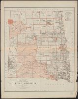
Creator:
Published / Created:
1879
Call Number:
821 1879
Container / Volume:
BRBL_00566
Image Count:
1
Resource Type:
Maps, Atlases & Globes
Description:
Scale 18 miles to 1 in.
Publisher:
Julius Bien,
Subject (Geographic):
Dakota Territory--Historical geography--Maps, North Dakota--Historical geography--Maps, and South Dakota--Historical geography--Maps
Subject (Name):
Roeser, C. (Charles)
Found in:
Beinecke Rare Book and Manuscript Library > Territory of Dakota / compiled from the official records of the General Land Office and other sources by C. Roeser.
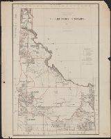
Creator:
Published / Created:
1879
Call Number:
832 1879
Container / Volume:
BRBL_00582
Image Count:
1
Resource Type:
Maps, Atlases & Globes
Abstract:
Shows township & county lines, Indian reservations, etc.
Description:
Relief shown by hachures.
Publisher:
Julius Bien,
Subject (Geographic):
Idaho--Maps
Subject (Name):
Bien, Julius, 1826-1909 and Roeser, C. (Charles)
Found in:
Beinecke Rare Book and Manuscript Library > Territory of Idaho : 1879 / compiled from the official records of the General Land Office and other sources by C. Roeser.
Creator:
Published / Created:
1876
Call Number:
832 1876
Container / Volume:
BRBL_00582
Image Count:
1
Resource Type:
Maps, Atlases & Globes
Description:
Relief shown by hachures.
Publisher:
The Office,
Subject (Geographic):
Idaho--Maps
Subject (Name):
Julius Bien & Co and Roeser, C. (Charles)
Found in:
Beinecke Rare Book and Manuscript Library > Territory of Idaho, 1876 / compiled from the official records of the General Land Office and other sources by C. Roeser, Principal Draughtsman, General Land Office.
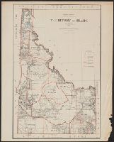
Creator:
Published / Created:
1883
Call Number:
832 1883
Container / Volume:
BRBL_00582
Image Count:
1
Resource Type:
Maps, Atlases & Globes
Description:
Relief shown by hachures.
Publisher:
The Office,
Subject (Geographic):
Idaho--Maps
Subject (Name):
Julius Bien & Co and Strum, G. P. (Gustave P.)
Found in:
Beinecke Rare Book and Manuscript Library > Territory of Idaho, 1883 / compiled from the official records of the General Land Office and other sources by G.P. Strum, Principal Draughtsman, Department of the Interior, General Land Office.
Branch:v1.61.8 ,Deployed:2024-06-20T11:15:04-04:00