Skip to search
Skip to main content
Skip to first result
Search
You Searched For
Date
1870 - 1879
Extent of Digitization
Completely digitized
Access
Public
Resource Type
Maps, Atlases & Globes
Creator
United States. General Land Office
Date Created
1870 to 1879
New Search
Search Results
Creator:
Published / Created:
1879
Call Number:
826 1879
Container / Volume:
BRBL_00577
Image Count:
1
Resource Type:
Maps, Atlases & Globes
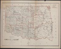
Description:
Includes dates of treaties with Indian nations., Library's copy annotated in black ink., Prime meridians: Washington and Greenwich., Relief shown by hachures., and Shows wagon roads, trails, railroads and natural features.
Publisher:
General Land Office,
Subject (Geographic):
Indian Territory--Maps
Subject (Name):
Roeser, C. (Charles)
Found in:
Beinecke Rare Book and Manuscript Library > Indian Territory, 1879 / compiled from the official records of the General Land Office and other sources by C. Roeser, Principal Draughtsman.
Creator:
Published / Created:
1876
Call Number:
75 1876
Container / Volume:
BRBL_00405
Image Count:
6
Resource Type:
Maps, Atlases & Globes
Description:
Insets: Alaska and Aleutian Islands. and Relief shown by hachures.
Publisher:
Photolith. and printed by J. Bien,
Subject (Name):
Bien, Julius, 1826-1909 and Roeser, C. (Charles)
Subject (Topic):
Canals--United States--Maps, Indian reservations--United States--Maps, Military reservations--United States--Maps, Railroad land grants--United States--Maps, Railroads--United States--Maps, and Surveying-
Found in:
Beinecke Rare Book and Manuscript Library > Map of the United States and territories, showing the extent of public surveys, Indian and military reservations, land grant R.R., rail roads, canals, and other details / compiled from the official surveys of the General Land Office, and other authentic s
Creator:
Published / Created:
1879
Call Number:
831 1879
Container / Volume:
BRBL_00579
Image Count:
1
Resource Type:
Maps, Atlases & Globes
Description:
Prime meridians: Greenwich and Washington. and Relief shown by hachures.
Publisher:
General Land Office,
Subject (Geographic):
Montana--Maps
Subject (Name):
Bien, Julius, 1826-1909 and Roeser, C. (Charles)
Found in:
Beinecke Rare Book and Manuscript Library > Montana Territory / compiled from the official records of the General Land Office and other sources by C. Roeser, principal draughtsman G.L.O.
Creator:
Published / Created:
1878
Call Number:
793 1878
Container / Volume:
BRBL_00520
Image Count:
1
Resource Type:
Maps, Atlases & Globes
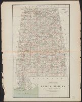
Description:
Scale : ca. 1:750,000.
Publisher:
The Office,
Subject (Geographic):
Alabama--Maps
Subject (Name):
Roeser, C. (Charles)
Found in:
Beinecke Rare Book and Manuscript Library > State of Alabama / compiled from the official records of the General Land Office and other sources by C. Roeser, principal draughtsman, G.L.O.
Creator:
Published / Created:
1878
Call Number:
818 1878
Container / Volume:
BRBL_00565
Image Count:
1
Resource Type:
Maps, Atlases & Globes
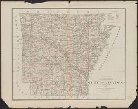
Description:
"J. A. Williamson, Commissioner"., Gives longitude west from Washington and Greenwich., and Relief shown by hachures.
Publisher:
General Land Office.,
Subject (Geographic):
Arkansas--Maps
Subject (Name):
Bien, Julius, 1826-1909 and Roeser, C. (Charles)
Found in:
Beinecke Rare Book and Manuscript Library > State of Arkansas / compiled from the official records of the General Land Office and other sources by C. Roeser, Principal Draughtsman, GLO, Department of the Interior.
Creator:
Published / Created:
1879
Call Number:
792 1879
Container / Volume:
BRBL_00518
Image Count:
1
Resource Type:
Maps, Atlases & Globes
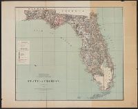
Description:
"J.A. Williamson, Commissioner." and Shows county seats, cities, towns, railroad limits, townships, swamps, hammocks, etc.
Publisher:
General Land Office,
Subject (Geographic):
Florida--Maps
Subject (Name):
Roeser, C. (Charles)
Subject (Topic):
Counties--Florida--Maps
Found in:
Beinecke Rare Book and Manuscript Library > State of Florida / Department of the Interior, General Land Office ; compiled from the official records of the General Land Office and other sources by C. Roeser.
Creator:
Published / Created:
1878
Call Number:
815 1878
Container / Volume:
BRBL_00560
Image Count:
1
Resource Type:
Maps, Atlases & Globes
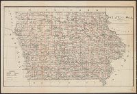
Description:
Prime meridians: Greenwich and Washington., Relief shown by hachures., and Shows county boundaries, towns and railroads.
Publisher:
General Land Office,
Subject (Geographic):
Iowa--Maps
Subject (Name):
Bien, Julius, 1826-1909 and Roeser, C. (Charles)
Found in:
Beinecke Rare Book and Manuscript Library > State of Iowa / Department of the Interior, General Land Office, J.A. Williamson, Commissioner ; compiled from the official records of the General Land Office and other sources by C. Roeser, Principal Draughtsman, G.L.O.
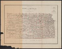
Creator:
Published / Created:
1879
Call Number:
825 1879
Container / Volume:
BRBL_00573
Image Count:
1
Resource Type:
Maps, Atlases & Globes
Description:
Prime meridians: Greenwich and Washington.
Publisher:
General Land Office,
Subject (Geographic):
Kansas--Maps
Subject (Name):
Bien, Julius, 1826-1909 and Roeser, C. (Charles)
Found in:
Beinecke Rare Book and Manuscript Library > State of Kansas / compiled from the official records of the General Land Office and other sources by C. Roeser ; photo lith. & print. by Julius Bien.
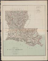
Creator:
Published / Created:
1879
Call Number:
795 1879
Container / Volume:
BRBL_00521
Image Count:
1
Resource Type:
Maps, Atlases & Globes
Description:
"J.A. Williamson, Commissioner.", Prime meridians: Washington and Greenwich., and Shows county boundaries and county seats, private grants, etc.
Publisher:
The Office,
Subject (Geographic):
Louisiana--Maps
Subject (Name):
Bien, Julius, 1826-1909 and Roeser, C. (Charles)
Found in:
Beinecke Rare Book and Manuscript Library > State of Louisiana / compiled from the official records of the General Land Office and other sources by C. Roeser, Principal Draughtsman, G.L.O.
Creator:
Published / Created:
1879
Call Number:
814 1879
Container / Volume:
BRBL_00557
Image Count:
1
Resource Type:
Maps, Atlases & Globes
Description:
At head of title: Department of the Interior, General Land Office, J.A. Williamson, Commissioner. and Prime meridians: Greenwich and Washington.
Publisher:
The Office,
Subject (Geographic):
Minnesota--Maps
Subject (Name):
Julius Bien & Co and Roeser, C. (Charles)
Found in:
Beinecke Rare Book and Manuscript Library > State of Minnesota : 1879 / compiled from the official records of the General Land Office and other sources by C. Roeser.
Branch:v1.61.6 ,Deployed:2024-06-12T09:55:33-04:00