Search
You Searched For
Search Results
- Creator:
- United States. Hydrographic Office
- Published / Created:
- [1851?]
- Call Number:
- 74cea 1851
- Container / Volume:
- BRBL_00394
- Image Count:
- 1
- Resource Type:
- Maps, Atlases & Globes
- Found in:
- Beinecke Rare Book and Manuscript Library > A chart illustrative of the cruise of the American Arctic expedition in search of Sir John Franklin, in the years 1850 & 1851.
- Creator:
- United States. Hydrographic Office
- Published / Created:
- 1904
- Call Number:
- 57 1904
- Container / Volume:
- BRBL_00302
- Image Count:
- 1
- Resource Type:
- Maps, Atlases & Globes
- Found in:
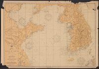
- Beinecke Rare Book and Manuscript Library > Asia, Japan and Korea : with the surrounding seas and the adjacent coastal region of China / published at Washington, D.C. Feb. 1904, at the Hydrographic Office. H.M. Hodges, Lieutenant Commander, U.S.N. Hydrographer.
- Creator:
- United States. Hydrographic Office
- Published / Created:
- 1904
- Call Number:
- 556cea 1904
- Container / Volume:
- BRBL_00293
- Image Count:
- 1
- Resource Type:
- Maps, Atlases & Globes
- Found in:
- Beinecke Rare Book and Manuscript Library > Asia, Japan and Korea : with the surrounding seas and the adjacent coastal region of China / published at Washington, D.C. Feb. 1904, at the Hydrographic Office. H.M. Hodges, Lieutenant Commander, U.S.N. Hydrographer.
- Creator:
- United States. Hydrographic Office
- Published / Created:
- 1850
- Call Number:
- 11cfk 1850C-4
- Container / Volume:
- BRBL_00770
- Image Count:
- 2
- Resource Type:
- Maps, Atlases & Globes
- Found in:
- Beinecke Rare Book and Manuscript Library > Pilot chart of the South Atlantic [cartographic material] / by M.F. Maury. Series C.
- Creator:
- United States. Hydrographic Office
- Published / Created:
- 1885
- Call Number:
- 615 1885A
- Container / Volume:
- BRBL_00332
- Image Count:
- 1
- Resource Type:
- Maps, Atlases & Globes
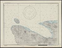
- Found in:
- Beinecke Rare Book and Manuscript Library > Red Sea and the valley of the Nile / compiled from data furnished by the Office of Naval Intelligence, March, 1885.
- Creator:
- Pathfinder (Ship)
United States. Hydrographic Office
- Published / Created:
- 1944
- Call Number:
- 258 1944
- Container / Volume:
- BRBL_00022
- Image Count:
- 1
- Resource Type:
- Maps, Atlases & Globes
- Found in:
- Beinecke Rare Book and Manuscript Library > South Pacific Ocean Solomon Islands : Malaita Island North Coast, Suaba Harbor / U.S. Navy, Hydrographic Office.
- Creator:
- Mitchell, John Murray, 1858-1905
Norris Peters Co
United States. Hydrographic Office
- Published / Created:
- [1896?]
- Call Number:
- 231 1896
- Container / Volume:
- BRBL_00020
- Image Count:
- 1
- Resource Type:
- Maps, Atlases & Globes
- Found in:
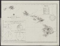
- Beinecke Rare Book and Manuscript Library > The Hawaiian Islands [cartographic material] : compiled from the latest information.
- Creator:
- United States. Hydrographic Office
- Published / Created:
- 1894
- Call Number:
- 556cea 1894
- Container / Volume:
- BRBL_00293
- Image Count:
- 1
- Resource Type:
- Maps, Atlases & Globes
- Found in:
- Beinecke Rare Book and Manuscript Library > The coasts of the Hwang Hai or Yellow Sea and Gulf of Pechili [cartographic material] : compiled from the latest information.
- Creator:
- United States. Hydrographic Office
- Published / Created:
- Sep., 1914 [that is, 1916]
- Call Number:
- BrSides Elephant Folio 2018 22
- Image Count:
- 1
- Resource Type:
- Maps, Atlases & Globes
- Found in:
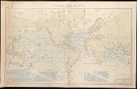
- Beinecke Rare Book and Manuscript Library > Tracks for full powered steam vessels with the shortest navigable distances in nautical miles from anchorage to anchorage, New York distances are measures to and from the Battery achorage.