Search
You Searched For
Search Results
- Creator:
- United States. Post Office Dept
- Published / Created:
- 1910
- Call Number:
- 766gmd T57 1912
- Container / Volume:
- BRBL_00475A
- Image Count:
- 1
- Resource Type:
- Maps, Atlases & Globes
- Found in:
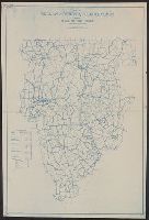
- Beinecke Rare Book and Manuscript Library > Map of Tolland County, Connecticut, showing rural delivery service / Post Office Department.
- Creator:
- United States. Post Office Dept
- Published / Created:
- 1910
- Call Number:
- 856gmd 1910
- Container / Volume:
- BRBL_00643
- Image Count:
- 1
- Resource Type:
- Maps, Atlases & Globes
- Found in:
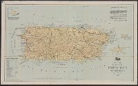
- Beinecke Rare Book and Manuscript Library > Post route map of Porto Rico : showing post offices with the intermediate distances on mail routes in operation on the 1st of December 1910 / published by order of Postmaster General Frank H. Hitchcock.
- Creator:
- United States. Post Office Dept
- Published / Created:
- 1912
- Call Number:
- 856gmd 1912
- Container / Volume:
- BRBL_00643
- Image Count:
- 1
- Resource Type:
- Maps, Atlases & Globes
- Found in:
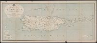
- Beinecke Rare Book and Manuscript Library > Post route map of Porto Rico : showing post offices with the intermediate distances on mail routes in operation on the 1st of December 1912 / published by order of Postmaster General Frank H. Hitchcock.
- Creator:
- United States. Post Office Dept
- Published / Created:
- [1914]
- Call Number:
- 842gmd 1914
- Container / Volume:
- BRBL_00600
- Image Count:
- 1
- Resource Type:
- Maps, Atlases & Globes
- Found in:
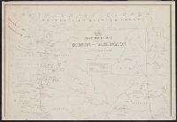
- Beinecke Rare Book and Manuscript Library > Post route map of the state of Arizona : showing post offices with the intermediate distances on mail routes in operation on the lst of January 1914 / published by order of Postmaster General A.S. Burleson, under the direction of David M. Hildreth, topogr
- Creator:
- United States. Post Office Dept
- Published / Created:
- [1881?]
- Call Number:
- 795 1881
- Container / Volume:
- BRBL_00521
- Image Count:
- 2
- Resource Type:
- Maps, Atlases & Globes
- Found in:
- Beinecke Rare Book and Manuscript Library > Post route map of the state of Louisiana : with adjacent parts of Mississippi, Arkansas and Texas, showing post offices / designed and constructed under the orders of Postmaster General David M. Key by W.L. Nicholson, topographer, P.O. Dept.
- Creator:
- United States. Post Office Dept
- Published / Created:
- 19--?]
- Call Number:
- 846gmd 1877
- Container / Volume:
- BRBL_00624
- Image Count:
- 2
- Resource Type:
- Maps, Atlases & Globes
- Found in:
- Beinecke Rare Book and Manuscript Library > Post route map of the state of Oregon and territory of Washington / designed and constructed under the orders of D.M. Key [by] W.L. Nicholson.
- Creator:
- United States. Post Office Dept
- Published / Created:
- 1883
- Call Number:
- 844gmd 1883
- Container / Volume:
- BRBL_00618
- Image Count:
- 4
- Resource Type:
- Maps, Atlases & Globes
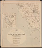
- Found in:
- Beinecke Rare Book and Manuscript Library > Post route map of the states of California and Nevada : showing Post Offices with the intermediate distances between them and mail routes in operation on 1st October 1883 / published by order of Postmaster General Walter Q. Gresham under the direction of
- Creator:
- United States. Post Office Dept
- Published / Created:
- [1883]
- Call Number:
- 831gmd 1883
- Container / Volume:
- BRBL_00581
- Image Count:
- 2
- Resource Type:
- Maps, Atlases & Globes
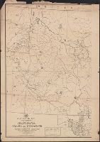
- Found in:
- Beinecke Rare Book and Manuscript Library > Post route map of the territories of Montana, Idaho, and Wyoming with parts of adjacent states and territories : showing post offices with intermediate distances between them and mail routes in operation on 1st October 1883 / published by order of Postmas
- Creator:
- United States. Post Office Dept
- Published / Created:
- 1883
- Call Number:
- 842gmd 1883
- Container / Volume:
- BRBL_00600
- Image Count:
- 2
- Resource Type:
- Maps, Atlases & Globes
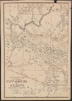
- Found in:
- Beinecke Rare Book and Manuscript Library > Post route map of the territories of New Mexico and Arizona : with parts of adjacent states and territories, showing post offices with the intermediate distances between them and mail routes in operation on 1st October 1883 / published by order of Postmas
- Creator:
- United States. Post Office Dept
- Published / Created:
- 1883
- Call Number:
- 821gmd 1883
- Container / Volume:
- BRBL_00566
- Image Count:
- 2
- Resource Type:
- Maps, Atlases & Globes
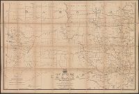
- Found in:
- Beinecke Rare Book and Manuscript Library > Post route map of the territory of Dakota with adjacent parts of Montana, Wyoming, Nebraska, Iowa and Minnesota : and portions of the Dominion of Canada, showing post offices with the intermediate distances between them and mail routes in operation on 1st