
You Searched For
« Previous
| 21 - 30 of 30 |
Next »
Search Results

- Creator:
- Hase, Johann Matthias, 1684-1742
Homann Erben (Firm)
Lowitz, G. M. (George Moritz), 1722-1774 - Published / Created:
- 1746
- Call Number:
- 1975 Folio 31
- Collection Title:
- [Atlas factice of 42 maps, produced by the Homann Erben firm]
- Image Count:
- 1
- Alternative Title:
- Mappe-monde qui represente les deux hemispheres savoir celui de l’orient et celui de l’occident, tiree des quatre cartes generales de feu M. le profess. Hasius, dressee par Mr. G.M. Lowitz et publiee par les Heritiers de Homann, avec privil. imper and Planiglobii terrestris mappa vniversalis
- Publisher:
- Homann Erben
- Subject (Topic):
- Atlases, German --Early works to 1800, Religion --Maps --Early works to 1800, and World maps --Early works to 1800
- Collection Created:
- [Nuremberg,
- Found in:
- Beinecke Rare Book and Manuscript Library > Planiglobii terrestris mappa universalis utrumq[ue] hemisphaerium orient. et occidentale repraesentans, ex IV. mappis generalibus, Hasianis composita et adjectis ceteris hemisphaeriis / [cartographic material] / designata a G.M. Lowizio ; excudentibus Hom

- Creator:
- Hase, Johann Matthias, 1684-1742
Homann Erben (Firm)
Lowitz, G. M. (George Moritz), 1722-1774 - Published / Created:
- 1746
- Call Number:
- 1973 Folio 30
- Collection Title:
- [Atlas factice of 32 maps and 1 distance table, produced by the Homann Erben firm]
- Image Count:
- 1
- Alternative Title:
- Mappe-monde qui represente les deux hemispheres savoir celui de l’orient et celui de l’occident, tiree des quatre cartes generales de feu M. le profess. Hasius, dressee par Mr. G.M. Lowitz et publiee par les Heritiers de Homann and Planiglobii terrestris mappa vniversalis
- Description:
- Map colored to show distribution of religions.
- Publisher:
- [Homann Erben]
- Subject (Topic):
- Atlases, German --Early works to 1800, Religion --Maps --Early works to 1800, and World maps --Early works to 1800
- Collection Created:
- [Nuremberg : s.n.,
- Found in:
- Beinecke Rare Book and Manuscript Library > Planiglobii terrestris mappa universalis utrumq[ue] hemisphaerium orient. et occidentale repraesentans, ex IV. mappis generalibus, Hasianis composita et adjectis ceteris hemisphaeriis / [cartographic material] / designata a G.M. Lowizio ; excudentibus Hom
- Creator:
- Homann, Johann Baptist, 1663-1724
- Published / Created:
- 1742?
- Call Number:
- 1975 Folio 31
- Collection Title:
- [Atlas factice of 42 maps, produced by the Homann Erben firm]
- Image Count:
- 1
- Alternative Title:
- Praefectura Generalis et Comitatus Provinciae
- Subject (Geographic):
- Alpes de Haute-Provence (France) --Maps --Early works to 1800, Alpes-Maritimes (France) --Maps --Early works to 1800, Bouches-du-Rhone (France) --Maps --Early works to 1800, France, Southern --Maps --Early works to 1800, Var (France) --Maps --Early works to 1800, and Vaucluse (France : Dept.) --Maps --Early works to 1800
- Subject (Topic):
- Atlases, German --Early works to 1800
- Collection Created:
- [Nuremberg,
- Found in:
- Beinecke Rare Book and Manuscript Library > Praefectura Generalis & Comitatus Provinciae una cum Terris adjacentibus in suas Dioeceses & Praeturas subdivisus ad prototypum del Islianum / [cartographic material] / excusus studion Homannianorum Heredum

- Creator:
- Homann Erben (Firm)
L'Isle, Guillaume de, 1675-1726 - Published / Created:
- 1741
- Call Number:
- 1975 Folio 31
- Collection Title:
- [Atlas factice of 42 maps, produced by the Homann Erben firm]
- Image Count:
- 1
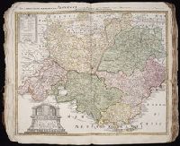
- Alternative Title:
- Carte de France dressee par Guillaume de L’Isle et accommodee par les Heritiers d’Homann
- Publisher:
- Homann Erben
- Subject (Geographic):
- France --Maps --Early works to 1800
- Subject (Topic):
- Atlases, German --Early works to 1800
- Collection Created:
- [Nuremberg,
- Found in:
- Beinecke Rare Book and Manuscript Library > Regni Galliae seu Franciae et Navarrae [cartographic material] : tabula geographica in usum elementorum geographiae schazianorum accom[m]odata / per Homannianos Heredes

- Creator:
- Homann Erben (Firm)
L’Isle, Guillaume de, 1675-1726 - Published / Created:
- 1741
- Call Number:
- 1973 Folio 30
- Collection Title:
- [Atlas factice of 32 maps and 1 distance table, produced by the Homann Erben firm]
- Image Count:
- 2
- Alternative Title:
- Carte de France dressee par Guillaume de L’Isle et accommodee par les Heritiers d’Homann
- Publisher:
- [Homann Erben]
- Subject (Geographic):
- France --Maps --Early works to 1800
- Subject (Topic):
- Atlases, German --Early works to 1800
- Collection Created:
- [Nuremberg : s.n.,
- Found in:
- Beinecke Rare Book and Manuscript Library > Regni Galliae seu Franciae et Navarrae [cartographic material] : tabula geographica in usum elementorum geographiae schazianorum accom[m]odata / per Homannianos Heredes

- Creator:
- Homann Erben (Firm)
Mayer, Tobias, 1723-1762 - Published / Created:
- 1747
- Call Number:
- 1975 Folio 31
- Collection Title:
- [Atlas factice of 42 maps, produced by the Homann Erben firm]
- Image Count:
- 1
- Alternative Title:
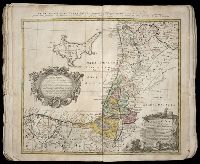
- Cercle d’Autriche : consistant dans l’Archiduche d’Autriche, le Duche de Stirie, de Carinthie, de Carniole, dans la Comte de Tyrol, et les pais autrichiens anterieurs dans la Souabe, avec ses confins, Circulus Austriacus, and Circvlvs Avstriacvs
- Publisher:
- Curantibus Homannianis Heridibus
- Subject (Geographic):
- Austria --Maps --Early works to 1800 and Europe, Central --Maps --Early works to 1800
- Subject (Topic):
- Atlases, German --Early works to 1800
- Collection Created:
- [Nuremberg,
- Found in:
- Beinecke Rare Book and Manuscript Library > S.R.I. circulus Austriacus [cartographic material] : quem componunt archid. Austriae, ducatus Stiriae, Carinthiae, Carnioliae, comit. Tyrolensis, ditionesque Sueviae austriacae, cum suis confiniis / a Tobia Majero ; curantibus Homannianis Heridibus, C.P.S
28.

- Creator:
- Homann Erben (Firm)
Mayer, Tobias, 1723-1762 - Published / Created:
- 1748
- Call Number:
- 1975 Folio 31
- Collection Title:
- [Atlas factice of 42 maps, produced by the Homann Erben firm]
- Image Count:
- 1
- Alternative Title:
- Etats de l’Eglise & du Grand Duche de Toscane, Etats de l’Eglise & du Grand Dvche de Toscane, and Status Ecclesiastici nec non Magni Ducatus Toscanae nova tabula geographica
- Publisher:
- Curantibus Homannianis Heredibus
- Subject (Geographic):
- Papal States --Maps --Early works to 1800 and Tuscany (Italy) --Maps --Early works to 1800
- Subject (Topic):
- Atlases, German --Early works to 1800
- Collection Created:
- [Nuremberg,
- Found in:
- Beinecke Rare Book and Manuscript Library > Statvs Ecclesiastici nec non Magni Ducatvs Toscanae nova tabula geographica [cartographic material] / secundum prinicipia legitimae delineationis descripta a Tob. Majero, Societ. Geogr. Sodali

- Creator:
- Mortier, David
Mortier, Pierre
Sanson, Nicolas, 1600-1667, creator - Published / Created:
- [1710]
- Call Number:
- 1973 Folio 10
- Image Count:
- 1
- Resource Type:
- Maps, Atlases & Globes
- Alternative Title:
- Premiere carte de la Meuse avec les pais, duchez et comtez voisins and Teatre de la guerre en Flandre et Brabant
- Description:
- Alternate title in upper margin: Premiere carte de la Meuse avec les pais, duchez et comtez voisins., Does not show troop positions or other military locations., Ferro meridian., Imperfect: western sheet (with title cartouche) wanting. Part of eastern map (inset of Arras/Cambrai region) pasted over correction[?]., Includes inset of Arras/Cambrai region and color illustration of battles at upper left and lower right., No. 47 of 69 maps bound together in composite atlas., Originally printed on 4 sheets., Presentee a son altesse Monseigneur le Duc & Comte [sic] de Marlborough, Marquis de Blandford, &c. &c. &c., par son tres-humble et tres-obeissant serviteur, Pierre Mortier, libraire a Amsterdam., Relief shown pictorially., and Scale [ca. 1:250 000].
- Publisher:
- Apud Petrum Mortier, et se vend a Londres chez David Mortier
- Subject (Topic):
- Spanish Succession, War of, 1701-1714 --Maps --Early works to 1800
- Found in:
- Beinecke Rare Book and Manuscript Library > Teatre de la guerre en Flandre [et] Brabant, les pays conquis et le Bas-Rhein etc

- Creator:
- Homann Erben (Firm)
Ovalle, Alonso de, 1601-1651
Techo, Nicolas del, 1611-1685 - Published / Created:
- A. MDCCXXXIII [1733]
- Call Number:
- 1975 Folio 31
- Collection Title:
- [Atlas factice of 42 maps, produced by the Homann Erben firm]
- Image Count:
- 1
- Alternative Title:
- Chili a Paraguay freti Magellanici
- Publisher:
- Editoribus Homannianis Heredibus
- Subject (Geographic):
- Santiago (Chile) --Maps --Early works to 1800 and South America --Maps --Early works to 1800
- Subject (Topic):
- Atlases, German --Early works to 1800
- Collection Created:
- [Nuremberg,
- Found in:
- Beinecke Rare Book and Manuscript Library > Typus geographicus [cartographic material] : Chili a Paraguay freti Magellanici &c., ex. PPbg. Alfonso d'Ovalle & Nicol. Techo nec non de Brouwer, Narbouroug, de Beauchesne &c., a Guiliel de l'Islio descripta, insuperque secundum recentiores du Frezier re