Bat. cum Privil. Ordin. Gener, Belgii Faederati--Title cartouche., Features include ornate title cartouche (top left) with cherubs, male and female figures and royal coat-of-arms supported by lion and unicorn, arms of Scotland supported by cherubs (above scale cartouche at top right), compass indicator and coasts shaded outwards., In Latin with some place names in English; explanations and title for index to places in Dutch and English., No. 7 of 69 maps bound together in composite atlas., Relief shown pictorially., Scale [ca. 1:960 000]., Scale statement reads: Milliaria Germanica Communia 15 in uno Gradu, with scale bar graded [0]-10; Milliaria Scotica Communia quorum 50 in uno Gradu, with scale bar graded [0]-34; Milliaria Gallica quae et Horae Itineris 20 in uno Gradu, with scale bar graded [0]-14., Shows grid, rivers and tributaries, lochs (shaded), trees, place and county names, settlements (symbols classified by importance in legend), territorial boundaries., Shows Scotland including the Hebrides and Orkney Islands., and The four cardinal points are written in the borders.
Appears in Schenk's Atlas contractus [ca. 1700]., Bar scales in milliaria Germanica communia, milliaria Gallica sive horae itineris, milliaria Italia, and milliaria Anglica., Ferro meridian., Includes decorative vignette in upper left of map., No. 48 of 69 maps bound together in composite atlas., Relief shown pictorially., and Scale [ca. 1:330 000].
Publisher:
[Peter Schenck]
Subject (Geographic):
Belgium --Maps --Early works to 1800 and Flanders --Maps --Early works to 1800
Gouwen, Gilliam van der Visscher, Nicolaes, 1649-1702, creator
Published / Created:
[1690?]
Call Number:
1973 Folio 10
Image Count:
1
Resource Type:
Maps, Atlases & Globes
Alternative Title:
Landkaart vertonende het Graafschap Holland
Description:
Alternate title in upper margin: Landkaart vertonende het Graafschap Holland, seer dienstig om te reysen na : en van syne naburige provincien, als mede de Hoven van Soestdyk, 't Loo en Cleef / t' Amsteldam door Nicolaus Visscher met privilegie., Bar scales in Milliaria Germanica communia and Milliaria Gallica sive horae itineris., Ferro meridian., Includes col. ill. of figures in title cartouche., No. 44 of 69 maps bound together in composite atlas., Place-names in Dutch., Relief shown pictorially., and Scale [ca. 1:300 000].
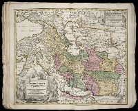
Dorn, Sebastian Hase, Johann Matthias, 1684-1742 Homann Erben (Firm)
Published / Created:
1744
Call Number:
1973 Folio 30
Collection Title:
[Atlas factice of 32 maps and 1 distance table, produced by the Homann Erben firm]
Image Count:
2
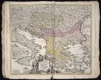
Alternative Title:
Carte d’Hongrie en general, contenant selon la division ancienne & methodique, la Hongrie, en particulier, la Croatie, la Dalmatie, la Bosnie, la Servie, la Boulgarie, la Principaute de Transylvanie, les Despotats de Walachie & de Moldav and Hungariae ampliori significatu et veteris vel methodicae, complexae regna: Hungariae Propriae, Crotiae, Dalmatiae, Bosniae, Serviae, Cumaniae, principatum: Transylvaniae, despotus: Walachiae, Moldaviae (exclusis ab eadem alienatis Galitia et Ludmomiria) in suas provincias ac partes divisae et quoad Imperantes ex Austriacis, Turcis et Venetis distinctae (juncta tamen propter commidatem Romania vel Romelia Turcica) tabula
Publisher:
Curantibus Homannianis Heredibus
Subject (Geographic):
Balkan Peninsula --Maps --Early works to 1800 and Hungary --Maps --Early works to 1800