Sanborn fire insurance maps are a rich source of historic data on the urban built environment of North America during the 19th and early 20th centuries. The atlases were created for the purpose of underwriting fire insurance policies, which depended upon accurate and frequently-updated information about construction materials, municipal and transportation infrastructure, industrial and commercial landuse and more. The Yale University Library Map Department scanned its holdings of Sanborn fire insurance maps (consisting primarily of Connecticut towns) in order to make the maps more accessible.
Alternative Title:
Insurance maps of New Haven, Connecticut, including East Haven, Insurance maps of New Haven, Connecticut, including Hamden and North Haven, Insurance maps of New Haven, Connecticut, including West Haven, and New Haven, Connecticut
Description:
Partial cadastral maps., Sheets contain information on population, water facilities and fire departments., SMLMAPL 766 N46 1924: Sheets disbound., Volume 1 includes "Map of Congested District" and 10 skeleton maps., Volume 3 includes 2 skeleton maps., Volume 5: sheets 514-516, 532, 556, 557, and 563-577 noted on index map as "proposed.", and Volumes include indices of streets and specials.
Subject (Geographic):
East Haven (Conn.)--Maps, Hamden (Conn.)--Maps, New Haven (Conn.)--Maps, North Haven (Conn.)--Maps, and West Haven (Conn.)--Maps
Subject (Name):
Library of Congress Ownership
Subject (Topic):
Fire risk assessment--Connecticut--East Haven--Maps, Fire risk assessment--Connecticut--Hamden--Maps, Fire risk assessment--Connecticut--New Haven--Maps, Fire risk assessment--Connecticut--North Haven--Maps, Fire risk assessment--Connecticut--West Haven--Maps, Real property--Connecticut--East Haven--Maps, Real property--Connecticut--Hamden--Maps, Real property--Connecticut--New Haven--Maps, Real property--Connecticut--North Haven--Maps, and Real property--Connecticut--West Haven--Maps
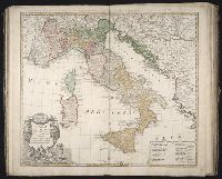
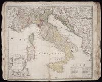
Homann Erben (Firm) L’Isle, Guillaume de, 1675-1726 Riccioli, Giovanni Battista, 1598-1671
Published / Created:
[1742?]
Call Number:
1973 Folio 30
Collection Title:
[Atlas factice of 32 maps and 1 distance table, produced by the Homann Erben firm]
Image Count:
2
Alternative Title:
Gli stati d’Italia secondo le osservationi fatte dalla Societa di Se di Parigi, dal R.P. Riccioli della S. die Giesu ed. altri astronomi, di prima geograficamente delineati ... Sgr. de l’Isle ... alle spese degl’ heredi d’Homann l’Anno MDCCXLII
Homann Erben (Firm) L'Isle, Guillaume de, 1675-1726 Riccioli, Giovanni Battista, 1598-1671
Published / Created:
[1742?]
Call Number:
1975 Folio 31
Collection Title:
[Atlas factice of 42 maps, produced by the Homann Erben firm]
Image Count:
1
Alternative Title:
Gli stati d’Italia secondo le osservationi fatte dalla Societa di Se di Parigi, dal R.P. Riccioli della S. die Giesu ed. altri astronomi, di prima geograficamente delineati ... Sgr. de l’Isle ... alle spese degl’ heredi d’Homan[n] l’An[n]o MDCCXLII
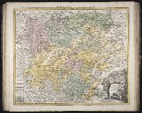
Italy divided according as its severall principalities extend, which are the territories of the Church, of the Catholick king, which contain the kingdomes of Naples, Sicily, Sardinia, and the Dukedome of Millain ... described by Sanson, corrected and amended by Will. Berry
Description:
Bar scales given in Italian miles, common leagues of Germany, great German leagues, common leagues of France, great French leagues, and common leagues of Spain., Dedicated To the most serene and most sacred majesty of Charles II ... by William Berry., No. 16 of 69 maps bound together in composite atlas., Relief shown pictorially., and Scale [ca. 1:2 300 000].
Publisher:
Sold by William Berry at the signe of the Globe between Charing-Cross and White Hall
Bar scales given in Stadia, mille Passus, milliaria unius horae, leucae Gallicae, and Dietce., Ferro meridian., No. 55 of 69 maps bound together in composite atlas., Relief shown pictorially., and Scale [ca 1:650 000].
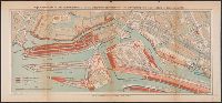
Das Freihafengebiet in Hamburg mit Umgebung 1895., Farbige Darstellung der bis Ende 1894 stattgehabten Aenderungen auf der Kehrwieder-Wandrahm-Jnsel und Umgebung unter Zugrundelegung des Zustandes von 1882., Hamburg und, and Hamburg und Umgebung (Sect Hamburg).
Description:
Farbige Darstellung der bis Ende 1894 stattgehabten Aenderungen auf der Kehrwieder-Wandrahm-Jnsel und Umgebung unter Zugrundelegung des Zustandes von 1882 -- Hamburg und Umgebung (Sect. Hamburg) -- Das Freihafengebiet in Hamburg mit Umgebung 1895 -- Karte des Hamburgischen Gebietes 1895 -- Hamburg und Umgebung (Sect. Hamm) -- Hamburg und Umgebung (Sect. Barmbeck) -- Hamburg und Umgebung (Sect. Eppendorf).
Bar scales given in mille pas geometriques, ou milles d'Italie, lieues communes de France, lieues d'une heure de Chemin, lieues communes d'Allemagne, and lieues communes de Suisse., Includes 33 coats of arms., No. 15 of 69 maps bound together in composite atlas., Relief shown pictorially., and Scale [ca. 1:585 000].
Publisher:
Chez H. Iaillot
Subject (Geographic):
Switzerland --Administrative and political divisions --Maps --Early works to 1800 and Switzerland --Maps --Early works to 1800