
You Searched For
« Previous
| 1 - 10 of 50 |
Next »
Search Results

- Creator:
- Sanborn Map Company
- Published / Created:
- August, 1923.
- Call Number:
- 776 B764 1923
- Container / Volume:
- BRBL_00502
- Image Count:
- 4
- Resource Type:
- Maps, Atlases & Globes
- Abstract:
- Fire insurance map, colored to show building construction, property boundaries and house and block numbers.
- Alternative Title:
- Aug. 1923, Bridgeville, Del. and Bridgeville, Del.
- Description:
- Coordinates not present on map and are approximated., Sheet 1 includes key to building colors and other features of construction, water facilities and fire department, index map for the adjoining sheets, and information about updates., Stamps below title: 427,0, Oct. 22, 1923., and Title from sheet 1.
- Publisher:
- Sanborn Map Company,
- Subject (Geographic):
- Bridgeville (Del.)--Maps.
- Subject (Topic):
- Fire risk assessment--Delaware--Bridgeville--Maps. and Real property--Delaware--Bridgeville--Maps.
- Found in:
- Beinecke Rare Book and Manuscript Library > Bridgeville, Sussex County, Delaware.

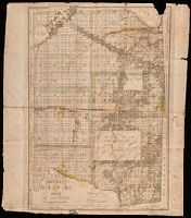
- Creator:
- Texas & Pacific Railway. Land Dept
- Published / Created:
- [1900?]
- Call Number:
- 796 C13 1900
- Container / Volume:
- BRBL_00527
- Image Count:
- 1
- Resource Type:
- Maps, Atlases & Globes
- Description:
- "The lands we are now controlling and offering for sale are colored in red.", Cadastral map., Includes text and "Table of land measures.", and Shows surveyed land sections by name or number, proposed line between Bexar and Milam land districts, roads, and creeks.
- Publisher:
- Daugherty & Ammerman,
- Subject (Geographic):
- Callahan County (Tex.)--Maps
- Subject (Name):
- Daugherty & Ammerman
- Subject (Topic):
- Real property--Texas--Callahan County--Maps
- Found in:
- Beinecke Rare Book and Manuscript Library > Callahan County, Texas / Office, Land Dept., Texas & Pacific Railway Co.

- Creator:
- South Australia. Hydraulic Engineer's Dept
- Published / Created:
- 1916 [i.e. 1917?]
- Call Number:
- 265 Ad32 1916
- Container / Volume:
- BRBL_00023
- Image Count:
- 1
- Resource Type:
- Maps, Atlases & Globes
- Description:
- "9/2/17." and Cadastral map of central Adelaide showing streets. Relief shown by contours.
- Publisher:
- Hydraulic Engineer,
- Subject (Geographic):
- Adelaide (S. Aust.)--Maps
- Subject (Topic):
- Real property--Australia--Adelaide (S. Aust.)--Maps
- Found in:
- Beinecke Rare Book and Manuscript Library > City of Adelaide / Hydraulic Engineer South Australia.
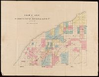
- Published / Created:
- [1859?]
- Call Number:
- BrSides Folio 2018 134
- Image Count:
- 1
- Resource Type:
- Maps, Atlases & Globes
- Description:
- Backed with linen. Manuscript annotations on map. Manuscript title on verso: Portage Lake. From the Richard H. Rickard Papers. and Coordinates not present on map and are approximated.
- Publisher:
- [publisher not identified],
- Subject (Geographic):
- Keweenaw Peninsula (Mich.)--Maps.
- Subject (Name):
- Rickard, Richard H.,---1885--Ownership. and St. Mary's Canal Mineral Land Company--Maps.
- Subject (Topic):
- Copper mines and mining--Michigan--Keweenaw Peninsula--Maps.
- Found in:
- Beinecke Rare Book and Manuscript Library > Copper lands of St. Mary's Canal Mineral Land Co. shaded red.
- Published / Created:
- [1859?]
- Call Number:
- BrSides Folio 2018 136
- Image Count:
- 1
- Resource Type:
- Maps, Atlases & Globes
- Description:
- Backed with linen. Manuscript annotations on map. Manuscript title on verso: Eagle River & Cliff Mine District. From the Richard H. Rickard Papers. and Coordinates not present on map and are approximated.
- Publisher:
- [publisher not identified],
- Subject (Geographic):
- Keweenaw County (Mich.)--Maps.
- Subject (Name):
- Rickard, Richard H.,---1885--Ownership. and St. Mary's Canal Mineral Land Company--Maps.
- Subject (Topic):
- Copper mines and mining--Michigan--Keweenaw County--Maps.
- Found in:
- Beinecke Rare Book and Manuscript Library > Copper lands of St. Mary's Canal Mineral Land Co. shaded red.
- Creator:
- Sanborn Map Company
- Published / Created:
- June, 1919.
- Call Number:
- 776 D75 1919
- Container / Volume:
- BRBL_00502
- Image Count:
- 15
- Resource Type:
- Maps, Atlases & Globes
- Abstract:
- Fire insurance map, colored to show building construction, property boundaries and house and block numbers.
- Alternative Title:
- Dover, Del., Dover, Delaware, and June 1919, Dover, Del.
- Description:
- "15 sheets (2729).", Coordinates not present on map and are approximated., Includes index to streets and buildings., Sheet 1 includes key to building colors and other features of construction, water facilities and fire department, index map for the adjoining sheets., and Stamps on sheet 1: CLF 33650; Sep. 9, 1919.
- Publisher:
- Sanborn Map Company,
- Subject (Geographic):
- Dover (Del.)--Maps.
- Subject (Topic):
- Fire risk assessment--Delaware--Dover--Maps. and Real property--Delaware--Dover--Maps.
- Found in:
- Beinecke Rare Book and Manuscript Library > Dover, Kent County, Delaware.
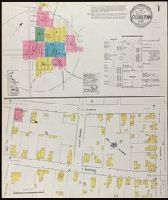
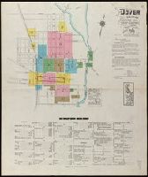
- Creator:
- Sanborn Map Company
- Published / Created:
- October, 1919.
- Call Number:
- 776 G295 1919
- Container / Volume:
- BRBL_00502
- Image Count:
- 7
- Resource Type:
- Maps, Atlases & Globes
- Abstract:
- Fire insurance map, colored to show building construction, property boundaries and house and block numbers.
- Alternative Title:
- Georgetown, Del., Georgetown, Delaware, and Oct. 1919, Georgetown, Del.
- Description:
- "2866 (7 sheets).", Coordinates not present on map and are approximated., Includes index to streets and buildings., Sheet 1 includes key to building colors and other features of construction, water facilities and fire department, index map for the adjoining sheets., and Stamps on sheet 1: CLF 33812; Dec. 31, 1919.
- Publisher:
- Sanborn Map Company,
- Subject (Geographic):
- Georgetown (Del.)--Maps.
- Subject (Topic):
- Fire risk assessment--Delaware--Georgetown--Maps. and Real property--Delaware--Georgetown--Maps.
- Found in:
- Beinecke Rare Book and Manuscript Library > Georgetown, Sussex County, Delaware.

- Published / Created:
- [ca. 1919]
- Call Number:
- BrSides Folio 2012 61
- Image Count:
- 1
- Resource Type:
- Maps, Atlases & Globes
- Description:
- "Plat B.H.", Imperfect: torn and chipped, with no loss of text., and Includes property previously owned by Madam C.J. Walker.
- Publisher:
- [s.n.]
- Subject (Geographic):
- Idlewild (Mich.)--Maps
- Subject (Name):
- Walker, C. J., Madam, 1867-1919
- Subject (Topic):
- Real property--Michigan--Idlewild
- Found in:
- Beinecke Rare Book and Manuscript Library > Idlewild no. 3, part of section no. 7, township no. 17, north range 12 west, Lake Co., Mich, including 10 sheets [cartographic material].
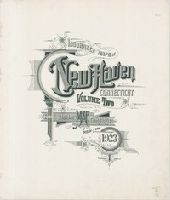
- Creator:
- Sanborn Map Company, issuing body
- Published / Created:
- 1924
- Call Number:
- 766 N46 1924
- Image Count:
- 92
- Resource Type:
- Maps, Atlases & Globes
- Abstract:
- Sanborn fire insurance maps are a rich source of historic data on the urban built environment of North America during the 19th and early 20th centuries. The atlases were created for the purpose of underwriting fire insurance policies, which depended upon accurate and frequently-updated information about construction materials, municipal and transportation infrastructure, industrial and commercial landuse and more. The Yale University Library Map Department scanned its holdings of Sanborn fire insurance maps (consisting primarily of Connecticut towns) in order to make the maps more accessible.
- Alternative Title:
- Insurance maps of New Haven, Connecticut, including East Haven, Insurance maps of New Haven, Connecticut, including Hamden and North Haven, Insurance maps of New Haven, Connecticut, including West Haven, and New Haven, Connecticut
- Description:
- Partial cadastral maps., Sheets contain information on population, water facilities and fire departments., SMLMAPL 766 N46 1924: Sheets disbound., Volume 1 includes "Map of Congested District" and 10 skeleton maps., Volume 3 includes 2 skeleton maps., Volume 5: sheets 514-516, 532, 556, 557, and 563-577 noted on index map as "proposed.", and Volumes include indices of streets and specials.
- Subject (Geographic):
- East Haven (Conn.)--Maps, Hamden (Conn.)--Maps, New Haven (Conn.)--Maps, North Haven (Conn.)--Maps, and West Haven (Conn.)--Maps
- Subject (Name):
- Library of Congress Ownership
- Subject (Topic):
- Fire risk assessment--Connecticut--East Haven--Maps, Fire risk assessment--Connecticut--Hamden--Maps, Fire risk assessment--Connecticut--New Haven--Maps, Fire risk assessment--Connecticut--North Haven--Maps, Fire risk assessment--Connecticut--West Haven--Maps, Real property--Connecticut--East Haven--Maps, Real property--Connecticut--Hamden--Maps, Real property--Connecticut--New Haven--Maps, Real property--Connecticut--North Haven--Maps, and Real property--Connecticut--West Haven--Maps
- Found in:
- Beinecke Rare Book and Manuscript Library > Insurance maps of New Haven, Connecticut. Volume 2.