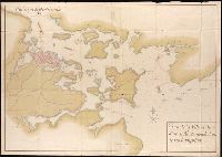
Bar scales given in English miles and Spanish leagues., Includes inset maps The Groyne, A general chart from England to Spain, Vigo and Bayonna, Porto, Lisbon and St. Ubes, and The harbour of Cadiz., No. 9 of 69 maps bound together in composite atlas., Relief shown pictorially., and Scale [ca. 1:1 800 000].
Publisher:
Sold by Christopher Browne at the Globe near the west end of St. Pauls Church
Henri Crublier d'Opterre journal and maps, [1776]-1783.
Container / Volume:
Bsd folder 10
Image Count:
3
Subject (Geographic):
America--Maps--Early works to 1800, Portsmouth (N.H.)--Maps--Early works to 1800, and United States--History--Revolution, 1775-1783--Maps--Early works to 1800.
"Printed from an electrotype.", Copy 2: Sheets 7, 10-11, 15, 17-18, 20 and 21 only. Hand colored., For a detailed description of the maps, see: The first Ordnance Survey map : a history and cartobibliography of the one-inch Old Series of England and Wales / Roger Hellyer and Richard Oliver. London : The Charles Close Society, 2015., Some sheets issued as quarter sheets., Statement of responsibility and imprint based on sheet 1., and Topographic series of England and Wales with relief shown by hachures.
Publisher:
Published by Colonel Colby ...,
Subject (Geographic):
England--Maps, Great Britain--Surveys--Maps, Military topography--Great Britain, and Wales--Maps