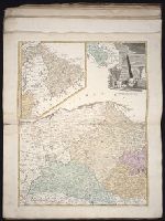
[Atlas factice of 32 maps and 1 distance table, produced by the Homann Erben firm]
Image Count:
2
Alternative Title:
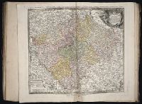
Belgium Catholicum seu decem provinciae Germaniae inferioris and Carte des Pais Bas catholiques ou des X provinces de l’Allegmagne inferieure, etc. dessinee au juste selon les exactes observations astronomiques et operations geometriques des Messur. Cassini, Snellius, Muschenbrok, etc. dressee par Sr. Tobias Maier, mathematicien; aux depens des Heritiers de Homann
Subject (Geographic):
Belgium --Maps --Early works to 1800 and Luxembourg --Maps --Early works to 1800
Bowles's geographical game of Europe, in a new, complete, and elegant tour through the different kingdoms, states, cities, &c. of Europe : designed by Dr. Nugent and Game of Geography
Description:
Imperfect: wanting totum, pillars and counters., In pencil on verso: ""23"" on both the right and left sides, ""Hazel M. Osborn Fund"", ""pc259 98.2.9"", and ""Beinecke Library Osborn pc 259""., Includes publisher�s advertisements on map and case label., On verso: Yale proprietary stamp in center., and Text and hand colored map mounted on linen.
Publisher:
Printed for the proprietors Bowles & Carver
Subject (Topic):
Geographical recreations --Europe --Early works to 1800 and Publishers’ advertisements --England --London --1795
Gussefeld, F. L. (Franz Ludwig), 1744-1807 Homann Erben (Firm) Schmidt, I. M.
Published / Created:
ao. 1784
Call Number:
1983 Folio 23
Collection Title:
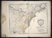
[Atlas factice of 50 maps, primarily by Johann Baptist Homann and/or issued by the Homann Erben
Image Count:
1
Alternative Title:
Treize Etats Unis de l'Amerique septentrionale, d'apress les meilleurs & speciales cartes angloises qui ont parues jusqu'ici and XIII Etats Unis de l'Amerique septentrionale, d'apress les meilleurs & speciales cartes angloises qui ont parues jusqu'ici