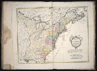
Subject: Map of the central part of the United States showing the middle Atlantic states, and the Ohio River Valley region. Includes anecdotes on the different Indian nations and the lands. Shows dates of settlements and agreements, locations of quarries,
Alternative Title:
Middle British colonies.
Description:
Differs from other copies in extension of the Connecticut River north beyond "Great Falls." Differs also in coloration of boundaries: Ohio River is colored as a boundary: Pennsylvania is shown as extending north to Lake Ontario, etc. and Shows "West longitude
Publisher:
Printed for Carington Bowles,
Subject (Geographic):
Canada--Maps--Early works to 1800, Middle Atlantic States--Maps--Early works to 1800, Northeastern States--Maps--Early works to 1800, and Ohio River Valley--Maps--Early works to 1800
Subject (Name):
Bowles, Carington, 1724-1793, publisher
Subject (Topic):
British--America--Maps--Early works to 1800 and Chron.--1771
Delaware --Maps --Early works to 1800, New Jersey --Maps --Early works to 1800, New York (State) --Maps --Early works to 1800, and Pennsylvania --Maps --Early works to 1800
Subject (Name):
Mifflin, Thomas, 1744-1800 and Wallis, John, 1734-1793
Subject (Topic):
Canals --Pennsylvania --Maps --Early works to 1800 and Roads --Pennsylvania --Maps --Early works to 1800
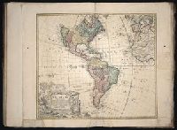
Cross collection no. 34., Double hemispherical map of the world showing countries, Dampier's voyage, winds, planetary systems, charts and appearance of the sun and moon. Relief shown pictorially., Imperfect: third name in imprint illegible. Hand col. Mounted on linen., Scale measured at center of hemisphere., and Shows California as an island.
Publisher:
Printed for I. Bowles ... Ca. Bowles ... and sold by [?] ... R. Sayer ... and Iohn King ...,
Bowles's geographical game of Europe, in a new, complete, and elegant tour through the different kingdoms, states, cities, &c. of Europe : designed by Dr. Nugent and Game of Geography
Description:
Imperfect: wanting totum, pillars and counters., In pencil on verso: ""23"" on both the right and left sides, ""Hazel M. Osborn Fund"", ""pc259 98.2.9"", and ""Beinecke Library Osborn pc 259""., Includes publisher�s advertisements on map and case label., On verso: Yale proprietary stamp in center., and Text and hand colored map mounted on linen.
Publisher:
Printed for the proprietors Bowles & Carver
Subject (Topic):
Geographical recreations --Europe --Early works to 1800 and Publishers’ advertisements --England --London --1795
Gussefeld, F. L. (Franz Ludwig), 1744-1807 Homann Erben (Firm) Schmidt, I. M.
Published / Created:
ao. 1784
Call Number:
1983 Folio 23
Collection Title:
[Atlas factice of 50 maps, primarily by Johann Baptist Homann and/or issued by the Homann Erben
Image Count:
1
Alternative Title:
Treize Etats Unis de l'Amerique septentrionale, d'apress les meilleurs & speciales cartes angloises qui ont parues jusqu'ici and XIII Etats Unis de l'Amerique septentrionale, d'apress les meilleurs & speciales cartes angloises qui ont parues jusqu'ici