Skip to search
Skip to main content
Skip to first result
Search
You Searched For
Date
1900 - 1943
Extent of Digitization
Completely digitized
Format
cartographic
Genre
Hand coloring
Date Created
1900 to 1943
New Search
Search Results
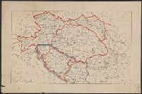
Published / Created:
1919?]
Call Number:
11hcf 1919C-3-8
Container / Volume:
BRBL_00010U
Image Count:
1
Resource Type:
Maps, Atlases & Globes
Description:
Hand colored regions and borders.
Publisher:
s.n.,
Subject (Geographic):
Balkan Peninsula--Maps and Europe, Eastern--Maps
Found in:
Beinecke Rare Book and Manuscript Library > Austria-Hungary.
Creator:
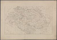
Published / Created:
[1918?-1943?]
Call Number:
304 1886A
Container / Volume:
BRBL_00740
Image Count:
9
Resource Type:
Maps, Atlases & Globes
Description:
BEIN Series 304 1886A: Imperfect: all sheets but C2-4, D2-4, E2-4 wanting., In upper margin of some maps: Domborzati áttekintés., Maps individually numbered and subtitled in upper margin, e.g.: B.4. Pola, Zara, Comacchio -- C2. Brno -- D.2. Kassa és Kraków -- E3. Koloszvár -- F.3. Bielcy, Kisziniew, Jassi., Publisher's name in lower margin differs: M. Kir. Térképészeti Intézet -- M. Kir. Állami Térképészeti Intézet -- M. Kir. Állami Térképészet -- M.kir. állami térképészet nyomása., Subtitles for the same map may differ according to ed., Title devised by cataloger., and Various eds. of some maps.
Publisher:
M. Kir. Térképészeti Intézet,
Subject (Geographic):
Europe, Eastern--Maps
Found in:
Beinecke Rare Book and Manuscript Library > [Kelet-Európa térképe] [cartographic material].
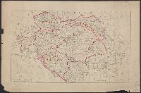
Published / Created:
1919?]
Call Number:
11hcf 1919C-3-4
Container / Volume:
BRBL_00010U
Image Count:
1
Resource Type:
Maps, Atlases & Globes
Description:
Hand colored borders. and Title supplied by cataloger.
Publisher:
s.n.,
Subject (Geographic):
Balkan Peninsula--Maps and Europe, Eastern--Maps
Found in:
Beinecke Rare Book and Manuscript Library > [Map of Balkan Peninsula and Eastern Europe].
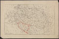
Published / Created:
1919?]
Call Number:
11hcf 1919C-3-5
Container / Volume:
BRBL_00010U
Image Count:
1
Resource Type:
Maps, Atlases & Globes
Description:
Hand colored borders. and Title supplied by cataloger.
Publisher:
s.n.,
Subject (Geographic):
Balkan Peninsula--Maps and Europe, Eastern--Maps
Found in:
Beinecke Rare Book and Manuscript Library > [Map of Balkan Peninsula and Eastern Europe].
Published / Created:
1919?]
Call Number:
11hcf 1919C-3-6
Container / Volume:
BRBL_00010U
Image Count:
1
Resource Type:
Maps, Atlases & Globes
Description:
Hand colored borders and place names. and Title supplied by cataloger.
Publisher:
s.n.,
Subject (Geographic):
Balkan Peninsula--Maps and Europe, Eastern--Maps
Found in:
Beinecke Rare Book and Manuscript Library > [Map of Balkan Peninsula and Eastern Europe].
Published / Created:
1919?]
Call Number:
11hcf 1919C-3-9
Container / Volume:
BRBL_00010U
Image Count:
1
Resource Type:
Maps, Atlases & Globes
Description:
Some hand coloring in blue and red pencil. and Title supplied by cataloger.
Publisher:
s.n.,
Subject (Geographic):
Balkan Peninsula--Maps and Europe, Eastern--Maps
Found in:
Beinecke Rare Book and Manuscript Library > [Map of Eastern Europe and the Balkan Peninsula].
Branch:v1.61.6 ,Deployed:2024-06-12T09:55:36-04:00