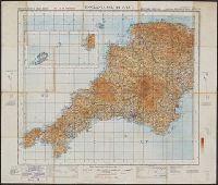
Altitudes given in feet., Contours at 200 feet vertical intervals., Copy 1: Imperfect: sheets 2-7 wanting. Accompanied by extra sheet 9 with minor corrections to 1925., Covers affixed verso not digitized., and Diagram showing adjoining sheets in margins.
England & Wales, G.S.G.S. ; no. 3957, and GSGS (Series) ; 3957.
Description:
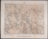
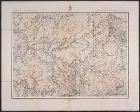
Imperfect: all sheets but "England, south west ... war revision" wanting., Includes diagram of adjacent sheets., Relief shown by contours and spot heights. Depths shown by isolines., and Some maps identified as Military edition; some sheets identified as War revision 1940.
Geographical Surveys West of the 100th Meridian (U.S.)
Published / Created:
1876
Call Number:
842 1876A
Container / Volume:
BRBL_00598
Image Count:
1
Resource Type:
Maps, Atlases & Globes
Description:
"5"--Verso., "Expeditions of 1871-1872 & 1873 under the comman, "Weyss, Herman & Lang, del."--Margin., Relief shown by hachures and spot heights., and Sheet no. 75 from Wheeler's Geographical exploration and surveys west of the 100th meridian topographical atlas.
Geographical Surveys West of the 100th Meridian (U.S.)
Published / Created:
[1876]
Call Number:
842 1876C
Container / Volume:
BRBL_00598
Image Count:
1
Resource Type:
Maps, Atlases & Globes
Description:
"Atlas sheet no. 83.", "Expeditions of 1871 & 1873 under the command of 1st. Lieut. Geo. M. Wheeler, Corps of Engineers, U.S. Army.", "Issued Mar. 18th 1876.", "Weyss, Herman & Lang, del.", and Relief shown by hachures and spot heights.
Publisher:
[U.S. Geographical Surveys West of the 100th Meridian],
Subject (Geographic):
Arizona--Surveys--Maps and New Mexico--Surveys--Maps
Geological and Geographical Survey of the Territories (U.S.)
Published / Created:
[1877]
Call Number:
833ca 1878AB
Container / Volume:
BRBL_00585
Image Count:
1
Resource Type:
Maps, Atlases & Globes
Description:
"56" printed in bottom right margin., Backed with linen. Stamp at top "10" crossed out with manuscript "No. 5" below., Relief shown by contours and spot heights., and Shows roads, springs, settlements, etc.
Publisher:
[The Survey],
Subject (Geographic):
Idaho--Maps, Utah--Maps, and Wyoming--Maps
Subject (Name):
Bien, Julius, 1829-1909, Gannett, Henry, 1846-1914, and Hayden, F. V. (Ferdinand Vandeveer), 1829-1887
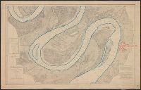
Backed with linen. River outline colored in blue; city of Greenville colored in red., Chart no. 39., Each sheet includes a list of authorities, note, and index chart.--Scale 1:360,000., Each sheet individually numbered, e.g.: Chart No.1, Chart No.2., Projected from a trigonometrical survey made in 1879-'80., and Relief shown by contours. Depths shown by soundings.
Publisher:
Mississippi River Commission,
Subject (Geographic):
Mississippi River and Mississippi River--Maps
Subject (Topic):
Nautical charts and Nautical charts--Mississippi River--Maps.
Bouma, Donald G Brehm, John J. B Darley, James M. (James Morrison) Holdstock, A. E National Geographic Society (U.S.). Cartographic Division
Published / Created:
1945
Call Number:
28 1945
Container / Volume:
BRBL_00023E
Image Count:
1
Resource Type:
Maps, Atlases & Globes
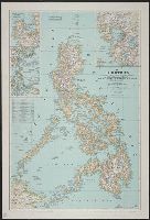
Description:
Copy 1: Mounted on linen., Insets: Location map of the Philippines. Scale 1:40,000,000 -- Lingayen, Table: Philippine provinces and their capital cities., and Topographic map with relief shown by hachures and spot heights; elevations and depths in feet.
In two sheets., Includes inset of The Hawaiian Islands., and Relief shown by contours and spot heights; contour interval 40 ft.
Publisher:
Dept. of the Interior, U.S. Geological Survey,
Subject (Geographic):
Hawaii--Oahu and Oahu (Hawaii)--Maps
Subject (Name):
Birdseye, C. H. (Claude Hale), 1878-1941, Davis, Geo. R. (George R.), Fowler, A. T, Hawaii. Territorial Survey., Marshall, R. B. (Robert Bradford), 1867-1949, and U.S. Coast and Geodetic Survey
Geological atlas projected to illustrate geographical explorations and surveys west of the 100th meridian of longitude. and Parts of eastern Arizona and western New Mexico
Description:
"6"--Verso., "By order of the honorable the Secretary of War. Under the direction of Brig. Gen. A.A. Humphreys, Chief of Engineers, U.S. Army.", "Expeditions of 1871, 1873 & 1875.", "Issued Mar: 18th, 1876.", "Weyss, Herman & Lang, del.", and Variant[?] lacking date of issuance statement.
Publisher:
U.S. Army, Corps of Engineers,
Subject (Geographic):
Arizona--Maps and New Mexico--Maps
Subject (Name):
Geographical Surveys West of the 100th Meridian (U.S.)