[Atlas factice of 96 maps by Blaeu, Visscher, Jansson, Hondius and others]
Image Count:
2
Resource Type:
Maps, Atlases & Globes
Description:
All four sides of map decorated with city views and costumed figures of different social classes. Includes coats of arms., Imperfect: torn along fold, with some loss of text; portions of decorative border cut or torn and repaired, with missing sections replicated in ms.; tears repaired., and No. 5 of 92 maps bound together.
Danckerts, Cornelis, ca. 1603-1656 Lazius, Wolfgang, 1514-1565
Published / Created:
[ca. 1631]
Call Number:
1983 Folio 19
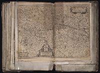
Collection Title:
[Atlas factice of 96 maps by Blaeu, Visscher, Jansson, Hondius and others]
Image Count:
1
Description:
Imperfect: Trimmed along edges, with no loss of text. Reinforced along edges with printed waste. Sheet measures 39 x 51 cm. No. 81 of 92 maps bound together. and Numbered 87 in pencil, 85 in ink, on verso.
Ferro meridian., From Bleau's Atlas major (German ed.). Zu Amsterdam : Bey Johannem Blaeu, [ca. 1670]., No. 58 of 69 maps bound together in composite atlas., Relief shown pictorially., and Scale [ca. 1:4 000 000].
Blaeu, Willem Janszoon, 1571-1638 Mercator, Gerhard, 1512-1594
Published / Created:
[1647]
Call Number:
1983 Folio 19
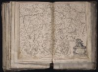
Collection Title:
[Atlas factice of 96 maps by Blaeu, Visscher, Jansson, Hondius and others]
Image Count:
1
Description:
Imperfect: mutilated along fold, with some loss of text. Reinforced along edges with manuscript and printed waste. Sheet measures 39.1 x 50.8 cm. No. 77 of 92 maps bound together. and Numbered 83 on verso.
Homann Erben (Firm) Mayer, Tobias, 1723-1762 Schneider, R. A.
Published / Created:
1747 [i.e. 1748?]
Call Number:
1975 Folio 31
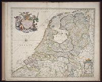
Collection Title:
[Atlas factice of 42 maps, produced by the Homann Erben firm]
Image Count:
1
Alternative Title:
Carte des XVII. provinces ou de l’Allemagne inferievre, dressee suivant la projection stereographique, et appueyee par les mesures faites de Mess. Cassini, Snellius et Mouschenbrok, par Mr. Tob. Majer de la Societe geographique, et publiee par les Heritiers de Homann, l’An 1748
Publisher:
Cura et Studio Homannianorum Heredum
Subject (Geographic):
Belgium --Maps --Early works to 1800, Benelux countries --Maps --Early works to 1800, Luxembourg --Maps --Early works to 1800, and Netherlands --Maps --Early works to 1800
[Atlas factice of 32 maps and 1 distance table, produced by the Homann Erben firm]
Image Count:
2
Alternative Title:
Carte des XVII. provinces ou de l’Allemagne inferievre, dressee suivant la projection stereographique, et appueyee par les mesures faites de Mess. Cassini, Snellius et Mouschenbrok, par Mr. Tob. Majer de la Societe geographique, et publiee par les Heritiers de Homann, l’An 1748
Publisher:
Cura et Studio Homannianorum Heredum
Subject (Geographic):
Belgium --Maps --Early works to 1800, Benelux countries --Maps --Early works to 1800, Luxembourg --Maps --Early works to 1800, and Netherlands --Maps --Early works to 1800