[Atlas factice of 42 maps, produced by the Homann Erben firm]
Image Count:
1
Resource Type:
Maps, Atlases & Globes
Alternative Title:
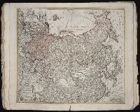
Imperii Russici et Tatariae universae tam majoris et Asiaticae, quam minoris et Europaeae tabula
Description:
"Cum privil. S.C.M. nec non R.M. Pol. et E. Sax.", Bar scale about 38 German miles to a centimeter., Decorated title cartouche depicts two hunters with rifles, a bear, and dog., Imperfect: edges frayed, torn along fold, with no loss of text. No. 33 of 42 maps bound together., In lower left margin: Notati etiam in hac mappa extant limites inter Russiam et Tatariam minorem post pacem recentissime a[nn]o 1739 initam., Includes dedicatory cartouche to Anna, Empress of Russia in upper left corner., Prime meridian: Paris., Relief shown pictorially., and Sea of Korea referred to as "Mare Orientale Minus."
Publisher:
Impensis Homannianorum Heredum
Subject (Geographic):
China--Maps--Early works to 1800., India--Maps--Early works to 1800., Japan--Maps--Early works to 1800., Korea--Maps--Early works to 1800., Russia--Maps--Early works to 1800., and Tibet (China)--Maps--Early works to 1800.
Subject (Name):
Anna,--Empress of Russia,--1693-1740., Homann Erben (Firm), and Schneider, R. A., engraver.
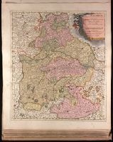
Backed with paper. Ms. no. "27" in upper right-hand corner. Sheet measures 52.7 x 53.7 cm. No. 27 of 87 maps bound together., Bar scales given in "milliaria Germanica" and "mill. Gallica"., Prime meridian: Ferro., and Relief shown pictorially.
Publisher:
Peter Schenk,
Subject (Geographic):
Austria--Maps--Early works to 1800. and Bavaria (Germany)--Maps--Early works to 1800.
"Cum Privilegio Ordin: General: Belgii Foederati.", Backed with paper. Ms. no. "95" in upper right-hand corner. Sheet measures 53.6 x 62.1 cm. No. 85 of 87 maps bound together., Bar scales given in "sesqui milliare Germanicum" and "milliaria Gallica.", Date given by Koeman, v. 5, p. 201, col. 2., and Relief shown pictorially.
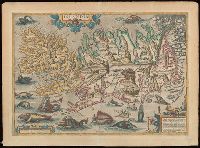
Blank on verso., Cartouche in lower right corner begins: "Islandia insula, iacet sub Polo Arctico ...", From unidentified edition of Ortelius's Theatrum orbis terrarum., Relief indicated pictorially., and Watermark.
Subject (Geographic):
Iceland--Maps--Early works to 1800.
Subject (Name):
Ortelius, Abraham, 1527-1598. Theatrum orbis terrarum
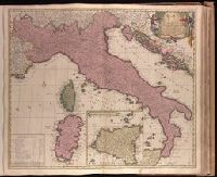
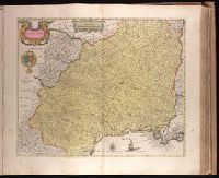
"Cum privilegio potentiss. D.D. ordin: Hollandiae et Westfrisiae.", Backed with paper. Ms. no. "65" in upper right corner. Sheet measures 53.7 x 62.5 cm. No. 60 of 87 maps bound together., Bar scales given in milliaria "Italica," "Germanica," and "Gallica.", Includes inset map of Sicily., Prime meridian: Ferro., and Relief shown pictorially.
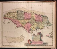
"Cum privilo. ordinm. Generalm. Belgii Foederati.", Backed with paper. Ms. no. "96" in upper right-hand corner. Sheet measures 53.6 x 62.9 cm. No. 86 of 87 maps bound together., Includes three bar scales., and Relief shown pictorially.
Publisher:
[Nicolaes Visscher,
Subject (Geographic):
Jamaica--Maps--Early works to 1800.
Subject (Name):
Albany Institute Stamp. and Anse, Luggert van, fl. 1690-1716, engraver.
Backed with paper. Ms. no. "53" in upper-right corner. Sheet measures 53.7 x 62.8 cm. No. 48 of 87 maps bound together., Bar scale given in "milliaria Gallica"., Prime meridian: Ferro., Relief shown pictorially., and Watermark.
Appears in Justus Danckerts's first two Atlas editions; see Koeman, C. Atlantes Neerlandici, vol. III, Dan 1, Dan 2., Backed with paper. Ms. no. "59" in upper right-hand corner. Sheet measures 53.8 x 62.8 cm. No. 54 of 87 maps bound together., Bar scales given in "milliaria Germanica communia" and "milliaria Gallica communia"., Prime meridian: Ferro., and Relief shown pictorially.
Publisher:
Theodore Danckerts,
Subject (Geographic):
Alsace (France)--Maps--Early works to 1800., Baden-Württemberg (Germany)--Maps--Early works to 1800., Lorraine (France)--Maps--Early works to 1800., and Saarland (Germany)--Maps--Early works to 1800.
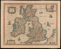
Bar scales given in "milliaria Anglica communia," "milliaria Anglica parva," and "milliaria Germanica communia.", From Joan Blaeu's Latin edition of Theatrum orbis terrarum (1648)., In Latin on verso, with caption title "Britannia," signature A, and paginated 1-2., Relief shown pictorially., Watermark., and With inset map "Orcades insulae."
Subject (Geographic):
Great Britain--Maps--Early works to 1800.
Subject (Name):
Blaeu, Joan, 1596-1673 and Blaeu, Joan, 1596-1673. Theatrum orbis terrarum.