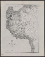
Peirce, Benjamin, 1809-1880 United States Coast Survey
Published / Created:
1869
Call Number:
846cea Or4 1869
Container / Volume:
BRBL_00623
Image Count:
1
Resource Type:
Maps, Atlases & Globes
Description:
In upper left margin: No. 16., Includes notes., Relief shown by hachures. Depths shown by soundings., and Removed from: United States Coast Survey, Annual report of the superintendent of the Coast Survey (1869).
Publisher:
U.S. Coast Survey,
Subject (Geographic):
Blanco, Cape (Or.)--Maps and Port Orford (Or.)--Maps
Subject (Name):
United States Coast Survey. Annual report of the superintendent of the Coast Survey. 1869
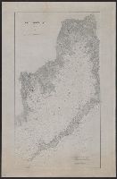
"No. 66" in upper right corner., Cross Collection no. 256., Depths shown by soundings., Inset: Carte des embouchures du fleuve St. Louis., Prime meridian: Paris., and Relief shown pictorially.
Publisher:
s.n.],
Subject (Geographic):
Gulf Coast (Fla.)--Maps--Early works to 1800
Subject (Name):
France. Dépôt des cartes et plans de la marine
Subject (Topic):
Coasts--Gulf States--Maps--Early works to 1800 and Coasts--Louisiana--Maps--Early works to 1800
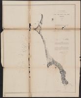
Faden, William, 1749-1836 Palmer, W. (William), 1739-1812 Roberts, Henry, Lieut
Published / Created:
1784
Call Number:
23 1784
Container / Volume:
BRBL_00019
Image Count:
1
Resource Type:
Maps, Atlases & Globes
Alternative Title:
Chart of the northwest coast of America and the northeast coast of Asia, explored in the years 1778 and 1779
Description:
Includes notes., Relief shown pictorially. Depths shown by soundings., and Sheet measures 53 x 80.5 cm.
Publisher:
Wm. Faden, geographer to the King, Charing Cross,
Subject (Geographic):
Bering Strait Region--Discovery and exploration--Maps--Early works to 1800, North America--Discovery and exploration--Maps--Early works to 1800, and Pacific Coast (North America)--Discovery and exploration--Maps--Early works to 1800
Subject (Name):
Cook, James,--1728-1779
Subject (Topic):
Discoveries in geography--Maps--Early works to 1800
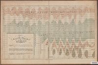
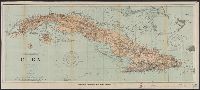
"482.", "Date of publication July 1898.", "To accompany report of Major General Commanding for 1898" outside lower margin., Includes compass rose., and Relief shown by hachures. Depths shown by soundings and isolines.
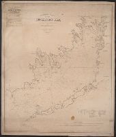
Depths shown by soundings. Distance shown, Includes abbreviations of types of bottoms, references, and tides., Mounted on linen. Includes adv. for "American Ship Windlass Company, Providence, R.I.", and Shows lighthouses, bouys, ferries, and some coastal towns.