Skip to search
Skip to main content
Skip to first result
Search
You Searched For
Extent of Digitization
Completely digitized
Access
Public
Repository
Beinecke Rare Book and Manuscript Library
Format
cartographic
Genre
Topographic maps
Subject (Name)
Witherspoon, D. C
New Search
Search Results
Creator:
Published / Created:
1912
Call Number:
848 G95 1912
Container / Volume:
BRBL_00632
Image Count:
1
Resource Type:
Maps, Atlases & Globes
Alternative Title:
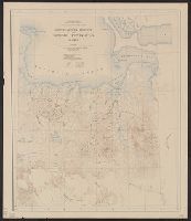
Geological Survey bulletin. 498. and Headwater region of Gulkana and Susitna Rivers, Alaska
Description:
"Bulletin 498, Plate I.", Relief shown by contours and spot heights., and Surveyed in 1896, 1909, 1910.
Publisher:
Geological Survey,
Subject (Geographic):
Gulkana River Region (Alaska)--Maps and Susitna River Region (Alaska)--Maps
Subject (Name):
Bagley, James Warren, 1881-1947, Brooks, Alfred H. (Alfred Hulse), 1871-1924, Giffin, C. E, and Witherspoon, D. C
Subject (Topic):
Geology--Alaska--Gullkana River Region--Maps and Geology--Alaska--Sustina River Region--Maps
Found in:
Beinecke Rare Book and Manuscript Library > Geologic reconnaissance map of headwater region of Gulkana and Susitna Rivers, Alaska / U.S. Geological Survey. Alfred H. Brooks, geologist in charge of division, topography and triangulation by D.C. Witherspoon, C.E. Giffin and J.W. Bagley.
Creator:
Published / Created:
[1918]
Call Number:
848 J953 1918
Container / Volume:
BRBL_00633
Image Count:
1
Resource Type:
Maps, Atlases & Globes
Description:
"1918.", "Surveyed in 1914-1916.", Includes notes., and Relief shown by contours and spot heights.
Publisher:
U.S. Geological Survey,
Subject (Geographic):
Juneau Region (Alaska)--Maps
Subject (Name):
Brooks, Alfred H. (Alfred Hulse), 1871-1924 and Witherspoon, D. C
Found in:
Beinecke Rare Book and Manuscript Library > Juneau and vicinity, Alaska / Alfred H. Brooks, geologist in charge of division ; topography by D.C. Witherspoon.
Creator:
Published / Created:
1907
Call Number:
848 Se87 1907
Container / Volume:
BRBL_00634
Image Count:
1
Resource Type:
Maps, Atlases & Globes
Description:
"Surveyed in 1903; additional areas from surveys made in 1900 and 1901 by U.S. Geological Survey". and Relief shown by contours; contour interval 200 feet.
Publisher:
U.S.G.S.,
Subject (Geographic):
Seward Peninsula (Alaska)--Maps
Subject (Name):
Brooks, Alfred H. (Alfred Hulse), 1871-1924 and Witherspoon, D. C
Found in:
Beinecke Rare Book and Manuscript Library > Reconnaissance map of northeastern portion of Seward Peninsula Alaska / U.S. Geological Survey ; Alfred H. Brooks, geologist in charge ; D.C. Witherspoon, topographer ; C.E. Hill, field assistant.
Creator:
Published / Created:
1922
Call Number:
848 T15 1922
Container / Volume:
BRBL_00634
Image Count:
1
Resource Type:
Maps, Atlases & Globes
Alternative Title:
Upper Tanana River Valley region, Alaska
Description:
"Surveyed 1898, 1907, 1908.", Includes inset responsibility map., and Relief shown by contours and spot heights.
Publisher:
U.S. Geological Survey,
Subject (Geographic):
Tanacross Region (Alaska)--Maps and Tanana River Valley (Alaska)--Maps
Subject (Name):
Brooks, Alfred H. (Alfred Hulse), 1871-1924, Peters, W. J. (William John), 1863-1942, and Witherspoon, D. C
Found in:
Beinecke Rare Book and Manuscript Library > Topographic reconnaissance map of Upper Tanana River Valley region, Alaska / U.S. Geological Survey; Alfred H. Brooks in charge of division; Control and topography by D.C. Witherspoon and J.W. Bagley; Upper Tanana River from boat traverses by W.J. Peters.
Branch:v1.61.6 ,Deployed:2024-06-12T09:55:33-04:00