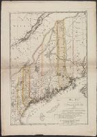
"Zu Ebelings Erdbeschreibung von America.", Also shows county boundaries., In upper right margin: No. IV., Includes index to land grants., Place names in German and English., Prime meridians: Greenwich a, Relief shown by hachures., and Sheet measures 75.5 x 53.8 cm.
Publisher:
Bey Carl Ernst Bohn,
Subject (Geographic):
Maine--Administrative and political divisions--Maps--Early works to 1800 and Maine--Maps--Early works to 1800
Subject (Name):
Bohn, Carl Ernst, Ebeling, Christophe Daniel, 1741-1817. Erdbeschreibung und Geschichte von Amerika, and Sander, Wilhelm, 1766-1836, engraver
Mappa Aestivarvm insularum, alias Barmvdas dictarum
Description:
Below map, list of proprietors in 12 columns flanked by coats-of-arms., Borders are hand colored., and Not hand colored. With watermark. Sheet measures 46 x 55 cm.
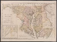
"W. Sander sculp.", "Zu Ebelings Erdbeschreibung von Amerika.", In upper right margin: No. X., Includes inset of western section of what is now Garrett and Allegany Counties., No watermark. Sheet measures 50.8 x 68.8 cm. Franklin Collection no. 131 1797-3., Place names in English and German., Prime meridians: Greenwich and Washington., Relief shown by hachures., and Watermark.
Publisher:
Bey Carl Ernst Bohn,
Subject (Geographic):
Delaware--Administrative and political divisions--Maps--Early works to 1800, Delaware--Maps--Early works to 1800, Maryland--Administrative and political divisions--Maps--Early works to 1800, and Maryland--Maps--Early works to
Subject (Name):
Bohn, Carl Ernst, Ebeling, Christophe Daniel, 1741-1817. Erdbeschreibung und Geschichte von Amerika, and Sander, Wilhelm, 1766-1836, engraver
"Zu Ebelings Erdbeschreibung von Amerika.", Also shows county boundaries., Atlas plate: No. III., Place names in German and English., Prime meridians: Greenwich and Washington., Relief shown by hachures. Depths shown by soundings., and Sheet measures 51 x 70 cm. Franklin Collection no. 131 1796 3.
Publisher:
Bey Carl Ernst Bohn,
Subject (Geographic):
Massachusetts--Administrative and political divisions--Maps--Early works to 1800 and Massachusetts--Maps--Early works to 1800
Subject (Name):
Bohn, Carl Ernst, publisher, Ebeling, Christophe Daniel, 1741-1817. Erdbeschreibung und Geschichte von Amerika, and Schmidt, Paulus Christoph, engraver
"Beilage zu 'Die neue Aera der Witwatersrand-Goldindustrie' von Felix Abraham (1894).", German and English., and Shows mine holding areas by owner.
Publisher:
Waterlow & Sons,
Subject (Geographic):
Witwatersrand (South Africa)--Maps
Subject (Name):
Abraham, Felix. Neue Aera der Witwatersrand-Goldindustrie. 1894
Subject (Topic):
Gold mines and mining--South Africa--Witwatersrand--Maps, Mining leases--South Africa--Witwatersrand--Maps, and Real property--South Africa--Witwatersrand--Maps
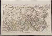
"W. Sander sc.", "Zu Ebelings Erdbeschreibung von Amerika.", Also shows county boundaries., Bar scales given in "Geographische Meilen 15 auf einen Grad" and "Englische meilen 69 4/25 auf einen Grad.", In upper right margin: No. IX., Place names in German and English., Prime meridians: Greenwich and Washington., Relief shown by hachures., Sheet measures 51 x 73.3 cm. Franklin Collection no. 131 1797 1., and Watermark.
Publisher:
Bey Carl Ernst Bohn,
Subject (Geographic):
Pennsylvania--Administrative and political divisions--Maps--Early works to 1800 and Pennsylvania--Maps--Early works to 1800
Subject (Name):
Bohn, Carl Ernst, publisher, Ebeling, Christophe Daniel, 1741-1817. Erdbeschreibung und Geschichte von Amerika, and Sander, Wilhelm, 1766-1836, engraver
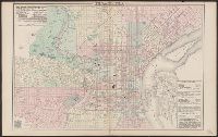
Describes location of steam railroad passenger depots., From Gray's atlas, p. 60-61., Legend in English, French and German., and Shows steam and horse railroads, wards, parks, etc.
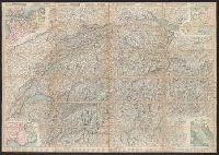
"Nr. 6210 BRB. 3.X.39"., Relief shown by shading, contours, and spot heights., and Text, illus., directory of mountain passes, and location map on verso.
Carta stradale della Svizzera, Carte routière de la Suisse, Reisekarte der Schweiz, and Road map of Switzerland
Description:
In French. Legend and scales in French, English, German, and Italian., Includes insets of northwestern Europe, north-central Europe, northern Italy, and the French-Italian coastal, and Mounted on verso: Luzern -- Bâle -- Genève -- Zuric -- Berne -- Lausanne.