Search
You Searched For
Search Results
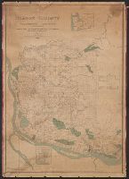
- Creator:
- Habersham, R. A
- Published / Created:
- 1888
- Call Number:
- 847 C65 1888
- Container / Volume:
- BRBL_00626
- Image Count:
- 1
- Resource Type:
- Maps, Atlases & Globes
- Found in:
- Beinecke Rare Book and Manuscript Library > Map of Clarke County, Washington Territory : compiled from the county records, rail road surveys, and other authentic data / compiled by R.A. Habersham.
- Creator:
- Veatch, A. C. (Arthur Clifford), 1878-1938
- Published / Created:
- 1906?]
- Call Number:
- 795gfa C645 1905
- Container / Volume:
- BRBL_00523
- Image Count:
- 1
- Resource Type:
- Maps, Atlases & Globes
- Found in:
- Beinecke Rare Book and Manuscript Library > Map of Cockfield artesian reservoir in northern Louisiana and southern Arkansas / by A.C. Veatch.
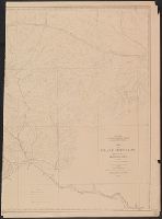
- Creator:
- Owen, F. D
- Published / Created:
- 1882
- Call Number:
- 831 C85 1882
- Container / Volume:
- BRBL_00580
- Image Count:
- 2
- Resource Type:
- Maps, Atlases & Globes
- Found in:
- Beinecke Rare Book and Manuscript Library > Map of Crazy Mountains and vicinity, Montana Ter. / Northern Transcontinental Survey, Raphael Pumpelly, director ; Department of Topography, A.D. Wilson, chief topographer ; drawn by F.D. Owen.
- Creator:
- United States. Census Office
- Published / Created:
- 1890
- Call Number:
- 826 1890
- Container / Volume:
- BRBL_00577
- Image Count:
- 1
- Resource Type:
- Maps, Atlases & Globes
- Found in:
- Beinecke Rare Book and Manuscript Library > Map of Indian Territory and Oklahoma.
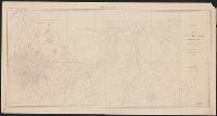
- Published / Created:
- 1882
- Call Number:
- 831 J89 1882
- Container / Volume:
- BRBL_00580
- Image Count:
- 1
- Resource Type:
- Maps, Atlases & Globes
- Found in:
- Beinecke Rare Book and Manuscript Library > Map of Judith Basin, Montana Ter. / Northern Transcontinental Survey, Raphael Pumpelly, director ; Department of Topography, A.D. Wilson, chief topographer ; lettering by F.D. Owen.
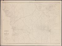
- Published / Created:
- 1882
- Call Number:
- 831 J89 1882A
- Container / Volume:
- BRBL_00580
- Image Count:
- 2
- Resource Type:
- Maps, Atlases & Globes
- Found in:
- Beinecke Rare Book and Manuscript Library > Map of Judith Basin, Montana Ter. / Northern Transcontinental Survey, Raphael Pumpelly, director ; Department of Topography, A.D. Wilson, chief topographer.
- Creator:
- Veatch, A. C. (Arthur Clifford), 1878-1938
- Published / Created:
- 1906?]
- Call Number:
- 795gfa Sa13 1905
- Container / Volume:
- BRBL_00523
- Image Count:
- 1
- Resource Type:
- Maps, Atlases & Globes
- Found in:
- Beinecke Rare Book and Manuscript Library > Map of Sabine artesian reservoir in northern Louisiana and southern Arkansas / by A.C. Veatch.
- Creator:
- Wilson, A. D. (Allen D.)
- Published / Created:
- 1882
- Call Number:
- 847 Y12 1882
- Container / Volume:
- BRBL_00627
- Image Count:
- 2
- Resource Type:
- Maps, Atlases & Globes
- Found in:
- Beinecke Rare Book and Manuscript Library > Map of Yakima Region, Washington Ter. / Northern Transcontinental Survey, Raphael Pumpelly, director ; A.D. Wilson, chief topographer ; R.U. Goode, topographer ; Frank Tweedy, Asst. ; F.D. Owen, chief draughtsman.
- Creator:
- Wilson, A. D. (Allen D.)
- Published / Created:
- 1882
- Call Number:
- 847 Y12 1882A
- Container / Volume:
- BRBL_00627
- Image Count:
- 2
- Resource Type:
- Maps, Atlases & Globes
- Found in:
- Beinecke Rare Book and Manuscript Library > Map of Yakima Region, Washington Ter. / Northern Transcontinental Survey, Raphael Pumpelly, director ; A.D. Wilson, chief topographer ; R.U. Goode, topographer ; Frank Tweedy, Asst. ; Fred D. Owen, chief draughtsman.
- Creator:
- Bien, Joseph R
- Published / Created:
- c1895.
- Call Number:
- 771 1895D
- Image Count:
- 1
- Resource Type:
- Maps, Atlases & Globes
- Found in:
- Beinecke Rare Book and Manuscript Library > Map of the state of New York.