Skip to search
Skip to main content
Skip to first result
Search
You Searched For
Extent of Digitization
Completely digitized
Format
cartographic
Language
English
New Search
Search Results
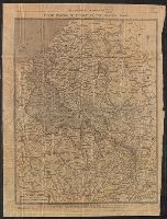
Published / Created:
[188-?]
Call Number:
825fac T364 1883
Container / Volume:
BRBL_00575
Image Count:
1
Resource Type:
Maps, Atlases & Globes
Description:
Includes advertisements for Thomas County Bank and Ike W. Crumly, asbtractor and dealer in real estate. and Shows townships and sections and railroads.
Publisher:
L.H. Everts & Co.,
Subject (Geographic):
Thomas County (Kan.)--Maps
Subject (Name):
L.H. Everts & Co
Found in:
Beinecke Rare Book and Manuscript Library > Thomas Co., Kansas.
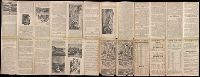
Published / Created:
1918
Call Number:
11hc 1918D
Container / Volume:
BRBL_00010E
Image Count:
2
Resource Type:
Maps, Atlases & Globes
Description:
Laminated page 3 and 4 from The Times, dated November 9, 1918. Text in English on verso.
Publisher:
The Times,
Subject (Geographic):
Belgium--Maps, France--Maps, and Luxembourg--Maps
Subject (Topic):
World War, 1914-1918--Maps
Found in:
Beinecke Rare Book and Manuscript Library > Three Months of Victory on the Western Front.
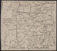
Published / Created:
c1886.
Call Number:
Zc35 886th
Image Count:
2
Resource Type:
Maps, Atlases & Globes
Alternative Title:
Fremont, Elkhorn & Missouri Valley R.R. and connections to the free homes for the million in northwestern Nebraska and southwestern Dakota
Description:
Imperfect: small hole in sheet, with some loss of text and map. and Text ([24] p.) on one side of sheet and map on verso.
Publisher:
Rand, McNally & Co., printers and engravers,
Subject (Geographic):
Nebraska--Description and travel., Nebraska--Maps., South Dakota--Description and travel., and South Dakota--Maps.
Subject (Name):
Fremont, Elkhorn, and Missouri Valley Railroad.
Subject (Topic):
Land use--Nebraska. and Land use--South Dakota.
Found in:
Beinecke Rare Book and Manuscript Library > Through northern Nebraska to the Black Hills : Elkhorn Valley Line : free homes for the 1,000,000 ...
Creator:
Published / Created:
[1883]
Call Number:
BrSides 2019 99
Image Count:
1
Resource Type:
Maps, Atlases & Globes
Description:
"U.S. Coast Survey A.D. Bache Supdt." at head of title. and From Charles H. Townsend's Commercial interests of Long Island Sound (1883).
Publisher:
[O.A. Dorman],
Subject (Geographic):
Long Island Sound (N.Y. and Conn.)--Maps.
Subject (Name):
Davis, Charles Henry, 1807-1877, Goldsborough, J. R., and Townshend, Charles Hervey, 1833-1904. Commercial interests of Long Island Sound.
Subject (Topic):
Tidal currents--Long Island Sound (N.Y. and Conn.)--Maps.
Found in:
Beinecke Rare Book and Manuscript Library > Tidal currents of Long Island Sound and approaches / by C.A. Schott, Computing Division, C.S., from observations by Lieuts. C.H. Davis & J.R. Goldsborough U.S.N. Assts.
Creator:
Published / Created:
1945
Call Number:
2726gmb 1945
Container / Volume:
BRBL_00023B
Image Count:
1
Resource Type:
Maps, Atlases & Globes
Alternative Title:
Its A.M.S. 9101 and Series (Standard map series designation system) ; 9101.
Description:
"Mercator projection.", Elevations shown by hachures and spot heights in meters., and Three classes of roads or trails are shown.
Publisher:
The Service,
Subject (Geographic):
Timor Island--Maps
Subject (Topic):
Transportation--Timor Island--Maps
Found in:
Beinecke Rare Book and Manuscript Library > Timor, special strategic map.
Creator:
Published / Created:
1942
Call Number:
68 T54 1942
Container / Volume:
BRBL_00350
Image Count:
1
Resource Type:
Maps, Atlases & Globes
Alternative Title:
Geographical Section, General Staff ; 4275 and GSGS (Series) ; 4275.
Description:
In upper margin: Algeria ... and Military grid.
Publisher:
Army Map Service, U. S. Army,
Subject (Geographic):
Tlemcen (Algeria)--Maps
Found in:
Beinecke Rare Book and Manuscript Library > Tlemcen.
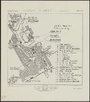
Published / Created:
1796
Call Number:
755cea 1796
Container / Volume:
BRBL_00441
Image Count:
3
Resource Type:
Maps, Atlases & Globes
Description:
Insets: A Plan of the Harbor of St. Augustine, ca. 1:28,000, 20 x 13 cm.; The Mouth of Nassau River, ca. 1:92,000, 11 x 11 cm.; The Mouth of St. Mary's River ca. 1:112,000, 11 x 10 cm.; The Harbor of Port Royal, ca. 1:400,000, 11 x 14 cm.; Charlestown Har
Publisher:
John Hamilton Moore,
Subject (Geographic):
East (U.S.)--Maps--Early works to 1800
Found in:
Beinecke Rare Book and Manuscript Library > To His Excellency General George Washington, President of the United States of North America, This Chart Including the Navigation from the Gulf of Florida to Philadelphia, Is respectfully dedicated ... by ... John Hamilton Moore.
Branch:v1.61.6 ,Deployed:2024-06-12T09:55:36-04:00