Skip to search
Skip to main content
Skip to first result
Search
You Searched For
Extent of Digitization
Completely digitized
Format
cartographic
Language
English
New Search
Search Results
Published / Created:
1796
Call Number:
90 1796
Container / Volume:
BRBL_00661
Image Count:
1
Resource Type:
Maps, Atlases & Globes
Description:
B. Tanner sculpt. and From the American Atlas, New York, John Reid, 1796. Cf. Phillips, List of Maps of America, vol.3, p. 804.
Publisher:
John Reid,
Subject (Geographic):
South America--Maps--Early works to 1800
Found in:
Beinecke Rare Book and Manuscript Library > A General Map Of South America. from the Best Surveys.
Published / Created:
1776
Call Number:
755 1776A
Container / Volume:
BRBL_00430
Image Count:
1
Resource Type:
Maps, Atlases & Globes
Description:
From the American Military Pocket Atlas of the British Colonies, which now are or may be The Theatre of War. See 71.1774, Pamphlet box. and Insets: Plan of Charlestown and St. Augustine.
Publisher:
Printed for R. Sayer and J. Bennett,
Subject (Geographic):
East (U.S.)--Maps--Early works to 1800
Found in:
Beinecke Rare Book and Manuscript Library > A General Map of the Southern British Colonies in America, comprehending North and South Carolina, Georgia, East and West Florida, with the Neighboring Indian Countries ... by B. Romans, 1776.
Published / Created:
1787
Call Number:
11 1787
Container / Volume:
BRBL_00006
Image Count:
2
Resource Type:
Maps, Atlases & Globes
Description:
Preliminary record.
Publisher:
Robert Sayer,
Subject (Geographic):
World--Maps--Early works to 1800
Found in:
Beinecke Rare Book and Manuscript Library > A General Map of the World or Terraqueous globe with all the new discoveries ... by Sam'l Dunn ...
Published / Created:
[1711?] and 1746.
Call Number:
3191hc 1746
Container / Volume:
BRBL_00041
Image Count:
1
Resource Type:
Maps, Atlases & Globes
Description:
G. Vertue, Sculp. and Insets: View of Potosi.
Publisher:
B. Lens,
Subject (Geographic):
Great Britain--Maps--Early works to 1800 and South America--Maps--Early works to 1800
Found in:
Beinecke Rare Book and Manuscript Library > A General map of Great Britain ..., To the right Honourable ... This map of South America ... H. Moll, Geographer. B. Lens, delin G. Vertus, Sculp.
Published / Created:
1667
Call Number:
66 1667
Container / Volume:
BRBL_00347
Image Count:
1
Resource Type:
Maps, Atlases & Globes
Subject (Geographic):
Morocco--Maps--Early works to 1800
Found in:
Beinecke Rare Book and Manuscript Library > A Generall Mapp of the Coast of Barbarie, where in are the Kingdoms, and Estates of Morocco, Fez, Algiers, Tunis, and Tripolis: also, the Kingdoms, Estates, and Deserts of Barca, Egipt, Libya, Biledulgerid, Segelmesse, and Darha ... By Monsieur Sanson. Il
Published / Created:
1796
Call Number:
75 1796A
Container / Volume:
BRBL_00396
Image Count:
1
Resource Type:
Maps, Atlases & Globes
Subject (Geographic):
United States--Maps--Early works to 1800
Found in:
Beinecke Rare Book and Manuscript Library > A Geographical View of all the Post Towns in the United States of America and their distances from each other according to the establishment of the Postmaster General, 1796. By Samuel A. Puddock, Accomptant, Boston. B. Callender, Sculp., Boston.
Published / Created:
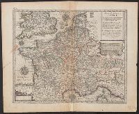
[1660?]
Call Number:
38 1660
Image Count:
1
Resource Type:
Maps, Atlases & Globes
Publisher:
Printed and Sould by Jo. Ouerton,
Subject (Geographic):
France--Maps--Early works to 1800
Found in:
Beinecke Rare Book and Manuscript Library > A Geographicall description of France ...
Published / Created:
[1822?]
Call Number:
767CA 1822
Container / Volume:
BRBL_00476
Image Count:
1
Resource Type:
Maps, Atlases & Globes
Description:
Engraved by A. Doolittle,1822.
Subject (Geographic):
Connecticut--Maps
Found in:
Beinecke Rare Book and Manuscript Library > A Geological Map of the Connecticut.
Published / Created:
[1750?]
Call Number:
3211cea 1750
Container / Volume:
BRBL_00055
Image Count:
2
Resource Type:
Maps, Atlases & Globes
Description:
Insets: Falmouth H., Plymouth Hr. Isle of Wight ca. 1:200,000.
Publisher:
Will. Mount and Tho. Page,
Subject (Geographic):
English Channel--Maps--Early works to 1800
Found in:
Beinecke Rare Book and Manuscript Library > A Large Chart of the Channel between England and France ... by Capt. Edmund Halley ...
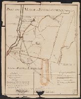
Published / Created:
1760
Call Number:
771fcm R297 1760
Container / Volume:
BRBL_00714
Image Count:
1
Resource Type:
Maps, Atlases & Globes
Description:
Color: pen and ink with green detail. and Explanation in bottom right hand side.
Subject (Geographic):
New York--Maps, Manuscript--Early works to 1800
Found in:
Beinecke Rare Book and Manuscript Library > A Map Claverack and Parts adjacent shewing the Claim of John Van Renselaer Esqr. The construction set up on the part of the crown, in the late action of intrustion. Done at New York, 9. Nov. 1760.
Branch:v1.61.6 ,Deployed:2024-06-12T09:55:31-04:00