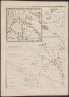
Nouvelle carte particuliére de l'Amerique ou sont exactement marquées ... and Nouvelle carte particuliére de l'Amerique ou sont exactement marquées la Nouvelle Bretagne, le Canada ou Nouvelle France, la Nouvelle Ecosse, la Nouvelle Angleterre, la Nouvelle
Description:
Appears in various eds. of Guillaume de L'Isle's Atlas nouveau., Each sheet has a unique caption title, all beginning with "Nouvelle carte particuliére de l'Amerique ou sont exactement marquées" and continuing as follows: Sheet 1, NW: une partie de la Baye d'Hudson, le pays des Kilistinons, la source de la grande Rivière de Mississipi, le pays des Illinois &c. -- Sheet 2, NE: la Nouvelle Bretagne, le Canada ou Nouvelle France, la Nouvelle Ecosse, la Nouvelle Angleterre, la Nouvelle York, la Pensilvanie, Mary-Land, la Caroline Septentrionale l'Ile Terre Neuve, le Grand Banc &c. -- Sheet 3, SW: les provinces suivantes comme la Caroline Meridionale, la Floride, la Louisiane, le Mexique, le Jucatan, le Guatimala, le Darien, & une partie de Cuba. -- Sheet 4, SE: les Iles de Bermude, la Iamaique, Saint Domingue, les Antilles, la Terre Ferme, &c., Engraver's name appears below the border at lower right corner of sheets 1-2 and 4: Sheet 1, NW: I.K. s. -- Sheet 2, NE: I. Condet s. -- Sheet 4, SE: J. Condet s., Main title in English, with individual sheet titles in French; place names in English., Northeast sheet. Sheet measures 65.5 x 53.9 cm. Stamp on verso: Yale, Horace Brown, 1900S., Note in upper left corner of Sheet 1 includes approbation by Edmund Halley: Mr. Popple undertook this map with the approbation of the Right Honourable Lords Commissioners of Trade and Plantations..., Relief shown pictorially., and Southwest sheet. Sheet measures 64.1 x 53.1 cm. Stamp: Yale Horace Brown 1900S.
Publisher:
Printed for Iohn Cóvens and Cornelius Mortier,
Subject (Geographic):
NorthAmerica--Maps--Early works to
Subject (Name):
Condet, Johannes, 1711-1781, engraver, Cóvens et Mortier, and L'Isle, Guillaume de, 1675-1726. Atlas nouveau
Nouvelle carte particuliére de l'Amerique ou sont exactement marquées ... and Nouvelle carte particuliére de l'Amerique ou sont exactement marquées la Nouvelle Bretagne, le Canada ou Nouvelle France, la Nouvelle Ecosse, la Nouvelle Angleterre, la Nouvelle
Description:
Appears in various eds. of Guillaume de L'Isle's Atlas nouveau., Each sheet has a unique caption title, all beginning with "Nouvelle carte partic, and Northwest sheet, state 1 (Babinski). Sheet measures 68.2 x 56.3 cm. Stamp on verso: Yale, Horace Brown, 1900S.
Publisher:
Printed for Iohn Cóvens and Cornelius Mortier,
Subject (Geographic):
NorthAmerica--Maps--Early works to
Subject (Name):
Condet, Johannes, 1711-1781, engraver, Cóvens et Mortier, and L'Isle, Guillaume de, 1675-1726. Atlas nouveau
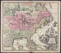
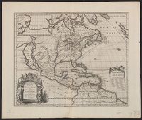
Also shows anchorages, currents, and routes of navigation along the coast., Includes historical notes, text, 10 insets of harbors, and a table showing that "North America is divided into the continent & the islands" according to geography and politics., and Rel
Publisher:
Printed for Robt. Sayer,
Subject (Geographic):
NorthAmerica--Maps--Early works to
Subject (Name):
Anville, Jean Baptiste Bourguignon d', 1697-1782 and Robert de Vaugondy, Didier, 1723-1786
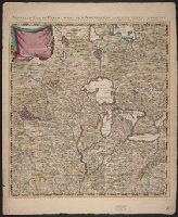
Appears in the author's Grosser atlas ... [between 1734 and 1750?], Covers North America from Quebec to the Gulf of Mexico, and to New Mexico in the west., In French, with title in Latin., and Includes decorative cartouche, historical notes and inset of "Les cos
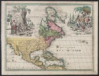
Includes ill. of natives in upper left and right., Relief shown pictorially., Some French notes., and Yale's copy annotated in ink in upper right margin: Nr073.
Covers area from northern South America to Greenland and includes the British Isles and the Azores., McLaughlin third state, with Lake Ontario shaded. Mounted on board. Sheet measures 47 x 61 cm. Ms. nos. on recto: 42, 28., Relief shown pictorially., and Shows C
Publisher:
Chez l'autheur, et chez Pierre Mariette, rue S. Iacques a l'Esperāce,
Subject (Geographic):
NorthAmerica--Maps--Early works to
Subject (Name):
Mariette, Pierre, 1603-1657 and Peyrounin, A., engraver
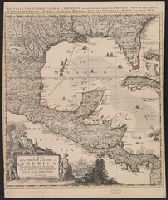
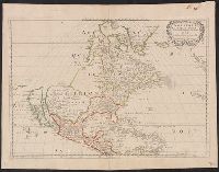
Appeared in Guillaume Sanson's Cartes générales de toutes les parties du monde., Cross collection no. 20., Differs from the 1650 Sanson map in its detail of the Gulf of California and its labeling of oceans--LVA web site., Imperfect: mutilated, with some loss of text. Mounted on linen., No. 1 of 3 maps mounted on linen., Relief shown pictorially., Shows California as an island. Includes the Southwest and Mexico., and Watermark.
Publisher:
Chez Pierre Mariette, ruë St. Jacques à l'Espera[n]ce, avec privilege de Sa Mai[es]té pour 20-äns,
Subject (Geographic):
NorthAmerica--Maps--Early works to
Subject (Name):
Mariette, Pierre, 1634-1716 and Sanson, Guillaume. Cartes générales de toutes les parties du monde