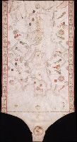
"Donnus Dominicus Vigliarolus Calaber de civitate Stili me fecit in urbe felicis Panormi 1577.", Color: red, green, and gold., Includes degrees of latitude along left edge: 60°N to 24°N., Includes six full compass roses, four half compass roses, and eight cherubs., Left portion of chart with illustration of the Pietá., and Title devised by cataloger.
Subject (Geographic):
Black Sea--Maps--Early works to 1800. and Mediterranean Sea--Maps--Early works to 1800.
Subject (Topic):
Nautical charts--Black Sea--Early works to 1800. and Nautical charts--Mediterranean Sea--Early works to 1800.
Jenkinson, Anthony, 1529-1611 Ortelius, Abraham, 1527-1598. Theatrum orbis terrarum Plantin, Christophe, approximately 1520-1589, printer
Call Number:
35 1562
Container / Volume:
BRBL_00099
Image Count:
1
Resource Type:
Maps, Atlases & Globes
Alternative Title:
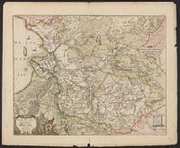
Russiae, Moscoviae et Tartariae descriptio
Description:
"Cum priuilegio.", From Abraham Ortelius's Theatrum orbis terrarum (Antwerp, 1584)., Imperfect: slightly chipped along fold in center, with slight loss of text. Backed with paper., In Latin on verso., and Relief shown pictorially.
Anville, Jean Baptiste Bourguignon d', 1697-1782, cartographer
Call Number:
400 1764
Container / Volume:
BRBL_00233
Image Count:
1
Resource Type:
Maps, Atlases & Globes
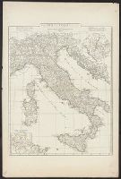
Description:
Appeared in Anville's Atlas général., Hand colored in outline., Includes 2 insets of Rome city region and "Urbs septicollis.", Includes four bar scales., Relief shown pictorially., and Watermark.
Subject (Geographic):
Italy--Historical geography--Maps--Early works to 1800 and Rome--Maps
Subject (Name):
Anville, Jean Baptiste Bourguignon d', 1697-1782. Atlas général
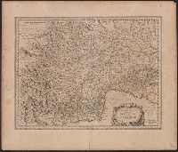
Appears in N. Vischer's Atlas minor sive geographia compendiosa, 1684., In lower right margin: Gedruckt t'Amsterdam by Frederick de Wit voor inde Calverstraet by den dam inde witte Pascaart., Map of Russian Far East, China and, and Sheet measures 45.5 x 56.5 cm.
Subject (Geographic):
China--Maps--Early works to 1800, Japan--Maps--Early works to 1800, and Russia (Federation)--Maps--Early works to 1800
Subject (Name):
L'Huilier, Joannes, engraver and Visscher, Nicolaes, 1649-1702. Atlas minor
Mounted on linen., Relief shown pictorially., and Variant without inset of "Fort Frederick oder Crown Point"; see B.B. McCorkle, Early printed maps of New England 1513-1800, 755.34.