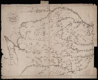
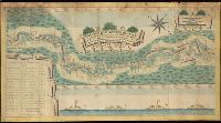
Чертезъ украинским и черкаскимъ городамъ от Москвы до Киева, и въ крымскую землу, дороги болшие, красные, черние, малшие.
Description:
Relief shown pictorially. and Stamp: Koenigl. Kartograph. Institut, Berlin. On verso in manuscript: "Mappa Expeditionis Moscovitica Duce Galicin Aõ 1681". Piece of paper with shelf mark attached at upper edge: "Cl. N. 16 [undeciphered].
Subject (Geographic):
Kiev (Ukraine : Oblast)--Maps--Early works to 1800.
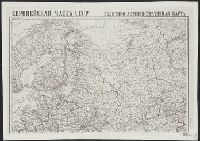
"Administrativnoe delenie na 10 i︠a︡nvari︠a︡ 1930 g.", "Glavlit No. A-59183.", "Goznak. Mytnai︠a︡, 17.", "Главлит No. A-59183.", "Гознак. Мытная, 17.", and Административное деление на 10 января 1930 г.
Publisher:
Izdanie Kartoizdatelʹstva NKVD RSFSR, and Издание Картоиздательства НКВД РСФСР,
Генеральной планъ Боровицкимъ порогамъ отъ Опеченской до Потерпельской пристани ...
Description:
Coordinates cannot be determined., Includes illustration and inset listing distances between various locations., Manuscript annotaions on verso., and Relief shown pictorially.
Subject (Geographic):
Novgorodskai︠a︡ oblastʹ (Russia)--Maps--Early works to 1800.
Karpinskiĭ, A. P. (Aleksandr Petrovich), 1846-1936
Published / Created:
1884
Call Number:
352ca Ur1 1884
Container / Volume:
BRBL_00109
Image Count:
3
Resource Type:
Maps, Atlases & Globes
Alternative Title:
Geologische Karte des Ostabhanges des Urals
Description:
Includes 2 inset maps: "Geologicheskai︠a︡ karta okrestnosteĭ S. Smolina" and "Geologicheskai︠a︡ karta dachi kamenskago zavoda.", Longitudinal coordinates shown on map are based on Pulkova., and Russian and German.