Skip to search
Skip to main content
Skip to first result
Search
You Searched For
Extent of Digitization
Completely digitized
Access
Public
Format
cartographic
Subject (Geographic)
Western Reserve (Ohio)--Maps
New Search
Search Results
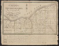
Published / Created:
1826
Call Number:
8045 1826
Container / Volume:
BRBL_00546
Image Count:
1
Resource Type:
Maps, Atlases & Globes
Description:
Colored., Descriptive text below map., and From McKenzie-Leffingwell estate.
Publisher:
William Sumner,
Subject (Geographic):
Western Reserve (Ohio)--Maps
Found in:
Beinecke Rare Book and Manuscript Library > Map of the Western Reserve Including the Fire Lands in Ohio. September 1826.
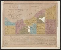
Published / Created:
1844
Call Number:
8045 1844
Container / Volume:
BRBL_00546
Image Count:
1
Resource Type:
Maps, Atlases & Globes
Description:
Descriptive text below map.
Publisher:
Taylor & Co.,
Subject (Geographic):
Western Reserve (Ohio)--Maps
Found in:
Beinecke Rare Book and Manuscript Library > Map of the Western Reserve Including the Fire Lands of Ohio.
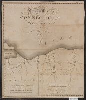
Published / Created:
1798]
Call Number:
8045 1798B
Container / Volume:
BRBL_00546
Image Count:
1
Resource Type:
Maps, Atlases & Globes
Description:
Text: Fire Land so called It being a grant of 500,000 Acres by the Legislature of the State of Connecticut to certain sufferers in the late war with Britain it is presumed that the Eastern.
Subject (Geographic):
Western Reserve (Ohio)--Maps
Found in:
Beinecke Rare Book and Manuscript Library > A Map of the Connecticut Western Reserve, from actual Survey, By Seath Pease.
Branch:v1.64.0 ,Deployed:2024-09-11T10:25:40-04:00