Skip to search
Skip to main content
Skip to first result
Search
You Searched For
Extent of Digitization
Completely digitized
Format
cartographic
Subject (Topic)
Canals--New York (State)--Maps
Search Results
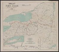
Creator:
Published / Created:
1912
Call Number:
771gma 1912
Container / Volume:
BRBL_00494
Image Count:
1
Resource Type:
Maps, Atlases & Globes
Description:
"J. A. Bensel, State Engineer and Surveyor."
Publisher:
State Engineer and Surveyor,
Subject (Geographic):
New York (N.Y.)--Maps
Subject (Name):
Bensel, John Anderson, 1863-
Subject (Topic):
Canals--New York (State)--Maps and Nautical charts--New York (State)
Found in:
Beinecke Rare Book and Manuscript Library > Canal map of the State of New York / to accompany the annual report of the State Engineer and Surveyor, 1912.
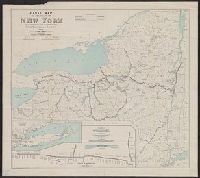
Creator:
Published / Created:
1911
Call Number:
771gma 1911
Container / Volume:
BRBL_00494
Image Count:
1
Resource Type:
Maps, Atlases & Globes
Description:
Insets: Profile of Barge Canal -- Long Island and southern part of New York.
Publisher:
State Engineer and Surveyor,
Subject (Geographic):
New York State Canal System (N.Y.)
Subject (Topic):
Canals--New York (State)--Maps and Nautical charts--New York (State)
Found in:
Beinecke Rare Book and Manuscript Library > Canal map of the state of New York : to accompany the annual report of the State Engineer and Surveyor.
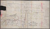
Creator:
Published / Created:
1858
Call Number:
771gma 1858R
Container / Volume:
BRBL_00494
Image Count:
1
Resource Type:
Maps, Atlases & Globes
Alternative Title:
Map & profiles of the N.Y. State canals.
Description:
"In examining these profiles be governed by figures, not by scale. The scales, horizontal and vertical, being too small to place the locks in accurate position in several places."
Publisher:
C. Van Benthuysen, printer,
Subject (Geographic):
New York (State)--Public works--Maps
Subject (Name):
Richmond, Van Rensselaer
Subject (Topic):
Canals--New York (State)--Maps
Found in:
Beinecke Rare Book and Manuscript Library > Map and profiles of New-York State canals / designed under direction of Van Rensselaer Richmond, State Engineer & Surveyor, to accompany his report for 1858.
Creator:
Published / Created:
1880
Call Number:
771gme 1880
Container / Volume:
BRBL_00494
Image Count:
2
Resource Type:
Maps, Atlases & Globes
Description:
Also shows drainage, canals and county boundaries.
Publisher:
Lith. by Weed, Parsons & Co.,
Subject (Geographic):
New York (State)--Administrative and political divisions--Maps and New York (State)--Maps
Subject (Name):
Seymour, Horatio, 1810-1886 and Smalley, Edward D
Subject (Topic):
Canals--New York (State)--Maps and Railroads--New York (State)--Maps
Found in:
Beinecke Rare Book and Manuscript Library > Map of the railroads of the State of New York / prepared under the direction of Horatio Seymour Jr., State Engr. & Surveyor, Edward D. Smalley, Deputy State Engr. & Survr.
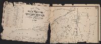
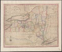
Creator:
Published / Created:
1832
Call Number:
771 1833
Container / Volume:
BRBL_00478
Image Count:
1
Resource Type:
Maps, Atlases & Globes
Alternative Title:
Profile of the northern canal and Profile of the western canal, H. Phelps, New York, 1832
Description:
Below title is lo
Publisher:
Humphrey Phelps,
Subject (Geographic):
Champlain Canal (N.Y.)--Maps, Erie Canal (N.Y.)--Maps, and New York (State)--Maps
Subject (Topic):
Canals--New York (State)--Maps
Found in:
Beinecke Rare Book and Manuscript Library > Map of the state of New York with the latest improvements / by H. Phelps.
Branch:v1.68.6 ,Deployed:2025-07-02T08:09:52-04:00