Skip to search
Skip to main content
Skip to first result
Search
You Searched For
Extent of Digitization
Completely digitized
Access
Public
Format
cartographic
New Search
Search Results
Published / Created:
1760?]
Call Number:
303 1760
Container / Volume:
BRBL_00033
Image Count:
1
Resource Type:
Maps, Atlases & Globes
Description:
Text on corner of Map.
Subject (Geographic):
Baltic Sea--Maps--Early works to 1800
Found in:
Beinecke Rare Book and Manuscript Library > An Exact chart of the North Sea ... Sold by W. Mount & T Page ...
Published / Created:
[1875?]
Call Number:
774J 1875
Container / Volume:
BRBL_00502
Image Count:
1
Resource Type:
Maps, Atlases & Globes
Alternative Title:
Historical map of Pennsylvania
Description:
Text attached. Various data on margin.
Publisher:
The Historical Society of Pennsylvania,
Subject (Geographic):
Pennsylvania--Maps
Found in:
Beinecke Rare Book and Manuscript Library > An Historical map of Pennsylvania showing the Indian Names of Streams and Villages, and paths of travel; The Sites of Old Forts and Battle Fields; The Sucessive Purchases from the Indians; and the names and dates of Counties and County Towns, with Tables
Published / Created:
[1795]
Call Number:
761 1795
Container / Volume:
BRBL_00447
Image Count:
2
Resource Type:
Maps, Atlases & Globes
Publisher:
O. Carleton & J. Norman,
Subject (Geographic):
Maine--Maps--Early works to 1800
Found in:
Beinecke Rare Book and Manuscript Library > An accurate Map of the District of Maine Being part of the Commonwealth of Massachusetts ...
Published / Created:
[1760]
Call Number:
361hc 1760
Container / Volume:
BRBL_00135
Image Count:
1
Resource Type:
Maps, Atlases & Globes
Subject (Geographic):
Prussia (Duchy)--Maps--Early works to 1800
Found in:
Beinecke Rare Book and Manuscript Library > An accurate Map of the Seat of War in the Empire of Germany as also in the Kingdom of Prussia with the adjacent Countries. By T. Kitchin Geogr.
Published / Created:
1794
Call Number:
755 1794C
Container / Volume:
BRBL_00436
Image Count:
1
Resource Type:
Maps, Atlases & Globes
Description:
L.C. 863-11.
Publisher:
H.D. Symonds,
Subject (Geographic):
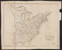
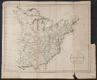
East (U.S.)--Maps--Early works to 1800
Found in:
Beinecke Rare Book and Manuscript Library > An accurate Map of the United States of America according to the Treaty of Peace of 1783. Russell del et Sculp.
Published / Created:
1794
Call Number:
755 1794C
Container / Volume:
BRBL_00436
Image Count:
1
Resource Type:
Maps, Atlases & Globes
Description:
L.C. 863-11.
Publisher:
H.D. Symonds,
Subject (Geographic):
East (U.S.)--Maps--Early works to 1800
Found in:
Beinecke Rare Book and Manuscript Library > An accurate Map of the United States of America according to the Treaty of Peace of 1783. Russell del et Sculp.
Published / Created:
1794
Call Number:
38cea 1757
Container / Volume:
BRBL_00169
Image Count:
1
Resource Type:
Maps, Atlases & Globes
Description:
Tables of data.
Publisher:
Laurie & Whittle,
Subject (Geographic):
Biscay, Bay of (France and Spain)--Maps--Early works to 1800
Found in:
Beinecke Rare Book and Manuscript Library > An accurate chart of the Bay of Biscay ... taken in 1756 & 1757 ... By Mr. Magin Engineer to the Marine.
Creator:
Published / Created:
1748
Call Number:
49 1748
Container / Volume:
BRBL_00267
Image Count:
1
Resource Type:
Maps, Atlases & Globes
Description:
Has watermark., In right top margin: Vol. II, page 792., and Includes rhumb lines and decorative cartouche.
Publisher:
s.n.],
Subject (Geographic):
Mediterranean Region--Maps--Early works to 1800
Subject (Topic):
Coasts--Mediterranean Region--Maps--Early works to 1800
Found in:
Beinecke Rare Book and Manuscript Library > An accurate chart of the Mediterranean and Adriatic Seas, with the archipelago & part of the Black Sea : exhibiting all the islands in those seas, as also, the adjacent countries on the continents of Europe, Africa & Asia / drawn from the most approved ma
Creator:
Published / Created:
1760?]
Call Number:
11 1755A
Container / Volume:
BRBL_00681
Image Count:
1
Resource Type:
Maps, Atlases & Globes
Alternative Title:
London magazine.
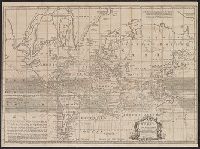
Description:
Cross collection no. 43. and Map of the world showing wind patterns and incomplete outline of Australia and New Zealand. Also shows time differences and some relief in hill shading.
Publisher:
s.n.,
Subject (Topic):
World maps--Early works to 1800
Found in:
Beinecke Rare Book and Manuscript Library > An accurate chart of the world with the new discoveries [cartographic material] : also a view of the general and coasting trade winds, monsoons or shifting trade winds and the variations of the compass, from the latest and best authorities / by T. Kitchen
Creator:
Published / Created:
[1785?]
Call Number:
BrSides Double Folio 2019 91
Image Count:
1
Resource Type:
Maps, Atlases & Globes
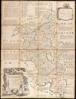
Description:
Dedicated to Charles, Duke of Marlborough., Imperfect: trimmed along outside graticule, with some loss of text. Dissected and mounted on linen., Includes notes about the county and shows boundaries, roads, parks and settlements., Plate 6 from: The large English atlas, or, A new set of maps of all the counties in England and Wales / Emanuel Bowen. London: Printed and sold by Robert Wilkinson, at No. 58, in Cornhill, successor to Mr John Bowles, deceased, [1785]., Prime meridian: London., and Relief shown pictorially.
Publisher:
Printed for R. Sayer at the Golden Buck in Fleet Street, John Bowles at the Black Horse in Cornhil, and Carrington Bowles in St. Pauls Church Yard,
Subject (Geographic):
Buckinghamshire (England)--Maps--Early works to 1800.
Subject (Name):
Bowen, Emanuel, 1693 or 1694-1767. Large English atlas, or, A new set of maps of all the counties in England and Wales., Bowles, Carington, 1724-1793, Bowles, John, 1701-1779, and Sayer, Robert, 1725-1794
Found in:
Beinecke Rare Book and Manuscript Library > An accurate map of Buckingham Shire divided into its hundreds : drawn from the best authorities assisted by the most approved modern maps with various improvements. Illustrated with historical extracts relative to natural history, produce, trade and manufactures and the present state of the principal towns / by Eman. Bowen, Geogr. to His Majesty.
Branch:v1.61.6 ,Deployed:2024-06-12T09:55:36-04:00