Skip to search
Skip to main content
Skip to first result
Search
You Searched For
Extent of Digitization
Completely digitized
Access
Public
Genre
Aerial views
Resource Type
Maps, Atlases & Globes
New Search
Search Results
Creator:
Published / Created:
1935?]
Call Number:
831am 1935
Container / Volume:
BRBL_00581
Image Count:
2
Resource Type:
Maps, Atlases & Globes
Alternative Title:
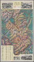
Glacier National Park aeroplane map
Description:
"M-40-35.", Includes ill., index, and distance table., Pictorial map., and Text and ill. on verso.
Publisher:
Great Northern,
Subject (Geographic):
Glacier National Park (Mont.)--Aerial views and Glacier National Park (Mont.)--Maps
Subject (Name):
McGill-Warner Co
Found in:
Beinecke Rare Book and Manuscript Library > Aeroplane map of Glacier National Park, Montana, with Logan Pass Detour.
Creator:
Published / Created:
1914]
Call Number:
831am 1914
Container / Volume:
BRBL_00581
Image Count:
2
Resource Type:
Maps, Atlases & Globes
Alternative Title:
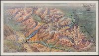
Glacier National Park
Description:
"5-27-1914 (100M).", Pictorial map., and Text and ill. on verso.
Publisher:
Great Northern Railway?,
Subject (Geographic):
Glacier National Park (Mont.)--Aerial views and Glacier National Park (Mont.)--Maps
Subject (Name):
McGill-Warner Co
Found in:
Beinecke Rare Book and Manuscript Library > Aeroplane view of Glacier National Park / Great Northern Railway.
Creator:
Published / Created:
c1905.
Call Number:
764am B65 1905
Container / Volume:
BRBL_00460
Image Count:
1
Resource Type:
Maps, Atlases & Globes
Description:
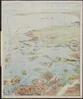
Copyright: 1905 by the Federal Engraving and Publishing Co., Boston, Mass., Index to points of interest on cover., Oriented with north to the left., and Title from cover.
Publisher:
Published by John F. Murphy,
Subject (Geographic):
Boston Harbor (Mass.)--Maps, Boston Harbor Islands (Mass.)--Maps, Boston Harbor Region (Mass.)--Maps, and South Shore Region (Mass. : Coast)--Maps
Subject (Name):
Murphy, John F
Found in:
Beinecke Rare Book and Manuscript Library > Bird's eye view of Boston Harbor and South Shore to Provincetown : showing steamboat routes.
Published / Created:
[192-?]
Call Number:
899am 1910
Container / Volume:
BRBL_00660
Image Count:
2
Resource Type:
Maps, Atlases & Globes
Alternative Title:
Bird's eye view of the Panama Canal
Description:
"Copyright and published by I.L. Maduro's Souvenir Store"., Includes text, relief profile, and map of Panama., Relief shown pictorially., and Text and ill. on verso.
Publisher:
I.L. Maduro,
Subject (Geographic):
Panama Canal (Panama)--Aerial views
Found in:
Beinecke Rare Book and Manuscript Library > Bird's eye view of the Panama Canal & map of Panama.
Creator:
Published / Created:
1902]
Call Number:
762am W588 1902
Container / Volume:
BRBL_00451
Image Count:
2
Resource Type:
Maps, Atlases & Globes
Alternative Title:
Bird's eye map of the White Mountains, reached by Boston & Maine
Description:
"Tourist Season 1902, in effect June 23"., Relief shown pictorially and by spot heights., and Verso: Railroad schedules.
Publisher:
[R.A. Supply Co.,
Subject (Geographic):
White Mountains (N.H. and Me.)--Maps
Subject (Topic):
Railroads--White Mountains (N.H. and Me.)--Maps
Found in:
Beinecke Rare Book and Manuscript Library > Bird's-eye map of the White Mountains, reached by Boston & Maine RR / R.A. Supply Co., eng'rs and printers.
Published / Created:
c1902.
Call Number:
762am M86 1902
Container / Volume:
BRBL_00451
Image Count:
1
Resource Type:
Maps, Atlases & Globes
Alternative Title:
Bird's eye view from Mt. Washington, New Hampshire
Description:
"Issued by Passenger Department of Boston & Maine R.R.", Includes key to 189 places., and Panel title: Bird's eye view from Mt. Washington, New Hampshire.
Publisher:
Geo. H. Walker & Co.,
Subject (Geographic):
Washington, Mount (N.H.)--Maps and White Mountains (N.H. and Me.)--Maps
Subject (Name):
Boston and Maine Railroad and Geo. H. Walker & Co
Found in:
Beinecke Rare Book and Manuscript Library > Birds-eye view from summit of Mt. Washington, White Mountains, New Hampshire.
Creator:
Published / Created:
[1890?]
Call Number:
764am B65 1890A
Container / Volume:
BRBL_00460
Image Count:
1
Resource Type:
Maps, Atlases & Globes
Description:
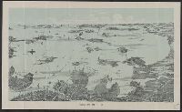
Shows deatails of islands, bays, and buildings.
Publisher:
Walker Lith. & Pub. Co.,
Subject (Geographic):
Boston (Mass.)--Maps
Subject (Topic):
Harbors--Massachusetts--Boston--Aerial views
Found in:
Beinecke Rare Book and Manuscript Library > Boston Harbor.
Creator:
Published / Created:
[1860?]
Call Number:
35311hc Se21 1860
Container / Volume:
BRBL_00112
Image Count:
1
Resource Type:
Maps, Atlases & Globes
Description:
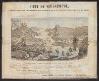
View of city with index to features.
Publisher:
Wood Engraving and Electrotype Establishment ... A.H. Jocelyn,
Subject (Geographic):
Sevastopolʹ (Ukraine)--Aerial views
Subject (Topic):
Fortification--Ukraine--Sevastopolʹ--Aerial views
Found in:
Beinecke Rare Book and Manuscript Library > City of Sevastopol : the only authentic view yet given, showing exact positions of all the fortifications with name and description of each appended / A.H. Jocelyn, eng.
Creator:
Published / Created:
1855
Call Number:
35311hc 1855
Container / Volume:
BRBL_00112
Image Count:
1
Resource Type:
Maps, Atlases & Globes
Description:
Shows fortifications and troop positions.
Publisher:
E. Gambart & Co.,, Goupil & Ce. ;, and Verlag von Goupil & Co. ;
Subject (Geographic):
Crimea (Ukraine)--Aerial views
Subject (Topic):
Crimean War, 1853-1856--Aerial views
Found in:
Beinecke Rare Book and Manuscript Library > La Crimée a vol d'oiseau / desinée et lithographiée par Mm. Ph. Benoist et Eug. Cicéri d'apres les plans et dessins relevés par ordre des Gouvernements Anglais, Français et Russe ; imp. Lemercier, Paris.
Creator:
Published / Created:
[1735]
Call Number:
BrSides Double Folio 2019 47
Image Count:
1
Resource Type:
Maps, Atlases & Globes
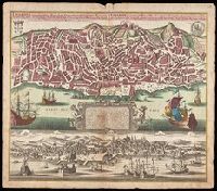
Alternative Title:
Lisabon die prächtigste Königl. Residenz Statt in Portugall u. florisanteste Handels Plaz am Austfluss des Tagi
Description:
"Cum gratia et privil. S.R.I. Vicariatus in partibus Rheni, Suevice, et Juris Franconici.", Historiated cartouche with note., Includes aerial view of "Lisabon" at bottom., and Manuscript number in upper right corner. From the Karpinski-von Wieser Map Collection.
Publisher:
[Matthaeus Seutter]
Subject (Geographic):
Lisbon (Portugal)--Aerial views--Early works to 1800, Lisbon (Portugal)--Maps--Early works to 1800, and Portugal--Lisbon
Found in:
Beinecke Rare Book and Manuscript Library > Lisabona magnificentissima Regia sedes Portugalliae et florentissimum Emorium ad oftia tagi situm / aeri incisium per Matth. Seutter S. Cæs. et Reg. Cathol. Maj. Geogr. Aug. Vindel. = Lisabon die prächtigste Königl. Residenz Statt in Portugall u. floris
Branch:v1.61.8 ,Deployed:2024-06-20T11:15:04-04:00