Iimage of the Saints Maurus and Placid surrounded by angels in lower left corner., Publisher statement precedes place of publication in imprint., Relief shown pictorially., and Watermark. Manuscript number in right corner: 42. From the Karpinski-von Wieser Map Collection.
Publisher:
Excusa per Haeredes Homan[n]ianos
Subject (Geographic):
Italy--Maps--Early works to 1800.
Subject (Name):
Benedictines and Benedictines--Italy--Maps--Early works to 1800
Subject (Topic):
Ecclesiastical geography and Ecclesiastical geography--Italy--Maps--Early works to 1800.
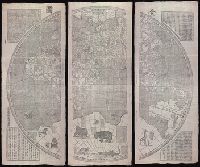
"咸豐庚申降婁海東重刊", "治理曆法極西南懷仁立法", Based on the world map of Joannes Blaeu., Includes illus. and text., Relief shown pictorially., Reprint., Shows the world in two hemispheres., and Wood block prints.
Publisher:
[publisher not identified],
Subject (Name):
Blaeu, Joan, 1596-1673.
Subject (Topic):
Chinese rare maps. and World maps--Early works to 1800.
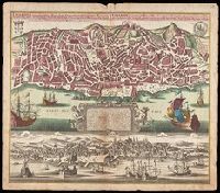
Lisabon die prächtigste Königl. Residenz Statt in Portugall u. florisanteste Handels Plaz am Austfluss des Tagi
Description:
"Cum gratia et privil. S.R.I. Vicariatus in partibus Rheni, Suevice, et Juris Franconici.", Historiated cartouche with note., Includes aerial view of "Lisabon" at bottom., and Manuscript number in upper right corner. From the Karpinski-von Wieser Map Collection.
Publisher:
[Matthaeus Seutter]
Subject (Geographic):
Lisbon (Portugal)--Aerial views--Early works to 1800, Lisbon (Portugal)--Maps--Early works to 1800, and Portugal--Lisbon
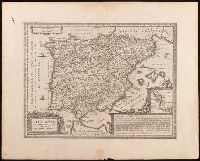
Relief shown pictorially., Verso blank., and Watermark. Manuscript number in upper left corner: 27. Manuscript annotations below neat line.
Publisher:
[Jan Jansson],
Subject (Geographic):
Albania, Albania--Maps--Early works to 1800., Europe--Macedonia, Greece--Maps--Early works to 1800., Macedonia (Republic)--Maps--Early works to 1800., and Macedonia--Maps--Early works to 1800.
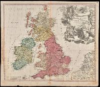
"Cum privilegio S.C.M.", Appeared in Homann's Atlas Novus Terrarum., Prime meridian: Ferro., Relief shown pictorially., Variant with portrait of George I in armour in the cartouche, Plymouth, England spelled correctly, and Delft, Netherlands misspelled "Dolft.", and Watermark. Manuscript number in upper right corner. From the Karpinski-von Wieser Map Collection.
Publisher:
[Johann Baptist Homann]
Subject (Geographic):
British Isles--Maps--Early works to 1800. and Europe--British Isles
Subject (Name):
Homann Erben (Firm) and Homann, Johann Baptist, 1663-1724. Atlas novus terrarum
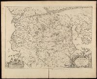
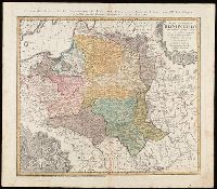
"La couleure violette marque les pays démembrés de la Pologne en 1772, conformément aux prétensions des trois Puissances voisines."--Lower left margin., Includes coat-of-arms, and 3 bar scales., Map in Latin; alternate title and legend in French., Prime meridian: Paris., Relief shown pictorially., and Watermark. Manuscript number in upper right corner. From the Karpinski-von Wieser Map Collection.
Publisher:
Luci publicae tradita per Homannianos Heredes
Subject (Geographic):
Belarus--Maps--Early works to 1800., Lithuania--Maps--Early works to 1800., Poland--Maps--Early works to 1800., and Ukraine--Maps--Early works to 1800.
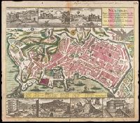
Includes index., Manuscript number in upper right corner: 63. Manuscript annotation in German at top. From the Karpinski-von Wieser Map Collection., Relief shown by shading and pictorially., and Views above upper and lower margins: Veduta del Molo -- Veduta di Castel del Ovo -- Veduta di Castel Nuovo -- Piazza del Mercato -- Veduta del l'Argo del Castello S. Elmo -- Vesuvius (with notes and inset profile of "Montis interioris conspectus") -- Veduta del Palazzo del Vice Re.
Publisher:
[Matthaeus Seutter]
Subject (Geographic):
Italy--Naples, Naples (Italy)--Aerial views--Early works to 1800., and Naples (Italy)--Maps--Early works to 1800.