Indian ledger drawings by Koba and Etahdleuh Doanmoe
Container / Volume:
Box 1
Image Count:
33
Description:
Only pages with text or illustrations digitized; large portion of ledger blank.
Subject (Topic):
Comanche art, Indian art --Collectors and collecting --United States, Indian art --Great Plains --Pictorial works, Indian art --North America --Collectors and collecting, Indian art --North America --Pictorial works, Indian art --United States, Indian arts --North America, Indians of North America --1870-1880, Indians of North America --1870-1890, and Kiowa art
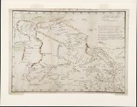
Manuscript map, in color, drawn by Bernardo Miera y Pacheco in San Felipe, Chihuahua, Mexico, in 1778. It reveals Spain's northernmost efforts to explore the interior of western North America on the Domínguez-Escalante Expedition, including present day New Mexico, Colorado, Utah, and Arizona.
Description:
Bernardo Miera y Pacheco was the cartographer on the Domínguez-Escalante Expedition. The expedition of ten men, led by Franciscan Fathers Francisco Atanasio Domínguez and Silvestre Vélez de Escalante, departed Sante Fe in late July 1776 and returned there on 2 January 1777., Note in later hand at upper edge of map: "Map of New Mexico with the latest discoveries.", and Scale [ca. 1:3,250,000] (W 112⁰ W 105⁰/N 40⁰ N 34⁰). Bar scale given in "leguas reguladas las marchas por tierra." Coordinates on map as: W260 W273/N42 N35.
Subject (Geographic):
Arizona--Maps--Early works to 1800, Colorado--Maps--Early works to 1800, New Mexico--Maps--Early works to 1800, Southwest, New--Maps--Early works to 1800, and Utah--Maps--Early works to 1800
Subject (Name):
Domínguez, Francisco Atanasio, active 1776, Domínguez-Escalante Expedition (1776), Miera y Pacheco, Bernardo de, and Vélez de Escalante, Silvestre, -1792
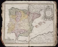
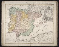
Homann Erben (Firm) Homann, Johann Baptist, 1663-1724
Published / Created:
1728?
Call Number:
1973 Folio 30
Collection Title:
[Atlas factice of 32 maps and 1 distance table, produced by the Homann Erben firm]
Image Count:
3
Alternative Title:
Regnorum Hispaniae et Portugalliae tabula generalis de l’Isliana and Reyno de Espanna dividido en dos grandes estados de Aragon y de Castilla, subdividido en muchas provincias donde se halla tambien el Reyno de Portugal
Publisher:
[Homann Erben]
Subject (Geographic):
Portugal --Maps --Early works to 1800 and Spain --Maps --Early works to 1800