The map shows the Klamath River and Cottonwood Creek Mining district in Siskiyou County, California, Hornbook and Klamath City, and indicates the routes of the Yreka and Ashland stage road and the California and Oregon Railroad. Scale, 2inches = 1 mile.
Subject (Name):
California and Oregon Railroad Company --Maps and Siskiyou County (Calif.) --Maps
Subject (Topic):
Gold mines and mining--California, Northern--Maps, Gold mines and mining--California--Klamath River, and Gold mines and mining--California--Siskiyou County
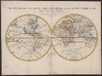
A re-issue by Jaillot of Jaugeon's 1688 map--Cf. Shirley, R. Mapping of the world, no. 538., Bernard Jaillot was the son of map maker Alexis Hubert Jaillot., Cross collection no. 21., and Relief shown pictorially.
Mediterranean Sea divided into the eastern and western seas, subdivides into its principal parts or seas ... described by Sanson, corrected and amended by William Berry
Description:
Based on La Mer Mediterranee divisee enses Principales Parties, ou Mers by Nicolas Sanson., Dedicated To the most serene and most sacred majesty James II ... by William Berry., Ms. mathematical annotations in left margin., No. 23 of 69 maps bound together in composite atlas., Relief shown pictorially., and Scale [ca. 1:610 000].
Publisher:
Sold by William Berry at the signe of the Globe between Charing-Cross and White-Hall
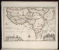
Bar scale given in milliaria Germanica communia., Covers west Africa from Tropic of Cancer southward., Ferro meridian., Map includes decorative title and scale statement cartouches with native figures and local fauna. Map interior displays three elephants., No. 59 of 69 maps bound together in composite atlas., Place names in Latin and Portuguese., Relief shown pictorially., and Scale [ca. 1:12 000 000].
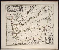
Bar scale given in milliaria Germanica., Ferro meridian., From Bleau's Atlas major (German ed.). Zu Amsterdam : Bey Johannem Blaeu, [ca. 1670]., No. 57 of 69 maps bound together in composite atlas., Oriented with north to the left., Relief shown pictorially., and Scale [ca 1:3 000 000].
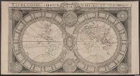
Ferro meridian., Gemeene Duytsche mylen van 15 in een graedt., No. 53 of 69 maps bound together in composite atlas., Relief shown pictorially., and Scale [ca 1:8 750 000].
Publisher:
By Frederick de Wit in de Kalversbraet in de Witte Pascaert
Part of the circle of Austria in which are the Dukedomes of Stiria, and Carinthia, of Carniola, in which are comprehended the countys of Chilley, and of Gorice, Windis-Marke, or Marquisat of Windes, described by Sanson, corrected and amended by William Berry
Description:
Bar scales in Italian miles, common leagues of Germany, great leagues of Germany, leagues of Hungary, common leagues of France, and great leagues of France or one hours travelling., Dedicated to The most high mighty and most excellent prince ----------------- prince of England, Scotland, France and Ireland, and Duke of Cornwall by William Berry, Ferro meridian., No. 28 of 69 maps bound together in composite atlas., Relief shown pictorially., and Scale [ca. 1:660 000].
Publisher:
Sold by William Berry at the sign of the Globe between Charing-Cross, and White-Hall