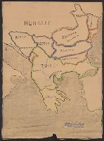
Map includes historical regions of Eastern Roumelia, Dobruja, and Bessarabia. Borders drawn in black ink, countries outlined in crayon. and Title supplied by cataloger.
Publisher:
s.n.,
Subject (Geographic):
Balkan Peninsula--Maps and Europe, Eastern--Maps
Subject (Topic):
Boundaries--Balkan Peninsula--Maps and Boundaries--Europe, Eastern--Maps
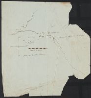
Color: Pen and ink drawing. and The map can only be definitely dated between the travels of Henry Middleton in 1608 and James Bruce in 1769. It is probably from around the 1690's or earlier because of the activity of the British East India Co. in this area at that time.
Subject (Geographic):
Jiddah (Saudi Arabia)--Maps, Manuscript--Early works to 1800
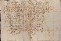
Coordinates not present on map and are approximated., Imperfect: mutilated., Relief shown by hachures., Shows government surveys with landowner and property boundaries drawn in., and Title devised by cataloger.