"This plat was drawne out in a paper Plat formerly made by me John Oliver for the Town of Dorchester and now by order it is drawn into parchment, April: 1661 by me Joshua Fisher." and Color. Pen and ink drawing.
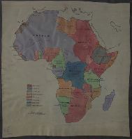
Subject (Geographic):
Dorchester (Boston, Mass.)--Maps--Early works to 1800
"Indentured made ... between John Baillie late of Lovell Hill ... in the County of Berks ... and James George Scott ... 1823. and 1. 1st schedule, 2nd schedule, 2. Description of meadow land, 3. The new plan, 4. The Indenture.
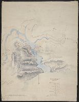
Color: Possibly pen and water color drawing. and Purpose of this map is to illustrate the movements and positions of the British warships & forces under Lord John Hays on the N. Coast of Spain.
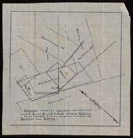
"Magnolia adversed Ypsilanti on conflicts marked A and B, and did not adverse Bullion. Piece marked C is in dispute between the Ypsilanti and Bullion.", From the Richard H. Rickard Papers., and Title devised by cataloger.