Search
You Searched For
Search Results
- Creator:
- Gibson, J. (John), active 1750-1792
- Published / Created:
- [1749]
- Call Number:
- BrSides 2019 63
- Image Count:
- 1
- Resource Type:
- Maps, Atlases & Globes
- Found in:
- Beinecke Rare Book and Manuscript Library > A map of New Scotland with its dependencies and a succint account of the country.
- Published / Created:
- 1863
- Call Number:
- 783 C899 1863
- Container / Volume:
- BRBL_00510
- Image Count:
- 1
- Resource Type:
- Maps, Atlases & Globes
- Found in:
- Beinecke Rare Book and Manuscript Library > [Military and topographic map of region about Culpepper Courthouse, Va.].
- Creator:
- Dodsley, Robert, 1703-1764.
- Published / Created:
- [1761]
- Call Number:
- 32 L84 1761
- Image Count:
- 1
- Resource Type:
- Maps, Atlases & Globes
- Found in:
- Beinecke Rare Book and Manuscript Library > A new and correct plan of London, Westminster and Southwark [cartographic material] : with several additional improvements not in any former survey.
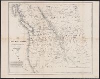
- Creator:
- Hood, Washington
- Published / Created:
- 1838]
- Call Number:
- 80 1838B
- Container / Volume:
- BRBL_00532
- Image Count:
- 1
- Resource Type:
- Maps, Atlases & Globes
- Found in:
- Beinecke Rare Book and Manuscript Library > Map of the United States, Territory of Oregon, west of the Rocky Mountains : exhibiting the various trading depots or forts occupied by the British Hudson Bay Company, connected with the western and northwestern fur trade / compiled in the Bureau of Topog
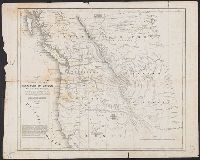
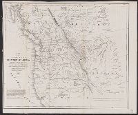
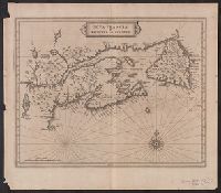
- Creator:
- Laet, Joannes de, 1581-1649
- Published / Created:
- 1630]
- Call Number:
- 73 1720
- Container / Volume:
- BRBL_00688
- Image Count:
- 1
- Resource Type:
- Maps, Atlases & Globes
- Found in:
- Beinecke Rare Book and Manuscript Library > Nova Francia et regiones adiacentes [cartographic material].
- Creator:
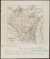
- Milwaukee Lith. & Engr. Co.
- Published / Created:
- [1873?]
- Call Number:
- BrSides 2018 157
- Image Count:
- 1
- Resource Type:
- Maps, Atlases & Globes
- Found in:
- Beinecke Rare Book and Manuscript Library > Map of Wisconsin : prepared for the legislative manual from offical records, 1873.
- Creator:
- St. Mary's Canal Mineral Land Company
- Published / Created:
- [1859]
- Call Number:
- BrSides Folio 2018 137
- Image Count:
- 1
- Resource Type:
- Maps, Atlases & Globes
- Found in:
- Beinecke Rare Book and Manuscript Library > Map showing iron mines in vicinity of Marquette, Lake Superior [cartographic material].
- Creator:
- Endicott & Co. (New York, N.Y.)
- Published / Created:
- [between 1870 and 1879?]
- Call Number:
- BrSides Folio 2018 142
- Image Count:
- 1
- Resource Type:
- Maps, Atlases & Globes
- Found in:
- Beinecke Rare Book and Manuscript Library > Land of the Seneca Mining Co., Lake Superior, Michigan.
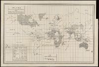
- Creator:
- United States. Bureau of Statistics
- Published / Created:
- [1898]
- Call Number:
- BrSides Folio 2019 4
- Image Count:
- 1
- Resource Type:
- Maps, Atlases & Globes
- Found in:
- Beinecke Rare Book and Manuscript Library > Colonies, dependencies and protectorates of the world [cartographic material] : showing area and population of the colonies, dependencies, protectorates and spheres of influence.
- Call Number:
- 403cb Ad45 1840
- Container / Volume:
- BRBL_00234
- Image Count:
- 1
- Resource Type:
- Maps, Atlases & Globes
- Found in:
- Beinecke Rare Book and Manuscript Library > Corso generale delle acque fra Adige, la r. strada da Venezia a Treviso, i monte, ed il mare / Pietro Zuliani inci.
- Published / Created:
- [approximately 1800?]
- Call Number:
- 400 1800
- Container / Volume:
- BRBL_00233
- Image Count:
- 1
- Resource Type:
- Maps, Atlases & Globes
- Found in:
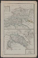
- Beinecke Rare Book and Manuscript Library > Vindelicia, Rhaetia, Noricum, Gallia Togata ; Italia media, sive Propria / Frentzel sc.
- Creator:
- Imray, James F. (James Frederick), 1829?-1891, author
James Imray and Son, publisher
- Call Number:
- 23cea 1884
- Container / Volume:
- BRBL_00021
- Image Count:
- 2
- Resource Type:
- Maps, Atlases & Globes
- Found in:
- Beinecke Rare Book and Manuscript Library > South and east coasts of Australia [in four charts]. Chart no. 2, Cape Northumberland to Cape Howe / compiled by James F. Imray F.R.G.S.
- Creator:
- Rand McNally and Company
- Call Number:
- 771 1895
- Container / Volume:
- BRBL_00479
- Image Count:
- 2
- Resource Type:
- Maps, Atlases & Globes
- Found in:
- Beinecke Rare Book and Manuscript Library > Rand, McNally & Co.'s New York [cartographic material].
- Creator:
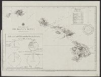
- Mitchell, John Murray, 1858-1905
Norris Peters Co
United States. Hydrographic Office
- Published / Created:
- [1896?]
- Call Number:
- 231 1896
- Container / Volume:
- BRBL_00020
- Image Count:
- 1
- Resource Type:
- Maps, Atlases & Globes
- Found in:
- Beinecke Rare Book and Manuscript Library > The Hawaiian Islands [cartographic material] : compiled from the latest information.
- Creator:
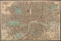
- Reynolds, James, active 1845-1864
- Published / Created:
- 1871
- Call Number:
- 32 L84 1871
- Container / Volume:
- BRBL_00051
- Image Count:
- 1
- Resource Type:
- Maps, Atlases & Globes
- Found in:
- Beinecke Rare Book and Manuscript Library > New map of London with the recent improvements : divided into quarter mile sections for measuring distances.
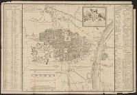
- Creator:
- Conti, Giuseppe, cartographer
- Published / Created:
- 1817
- Call Number:
- 40 T729 1809
- Image Count:
- 1
- Resource Type:
- Maps, Atlases & Globes
- Found in:
- Beinecke Rare Book and Manuscript Library > Pianta della città di Torino / designata dall'ing. top. Giuseppe Conti.
- Creator:
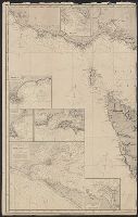
- Vidal, A. T. E. (Alexander Thomas Emeric), 1792-1863, author
- Call Number:
- 655 1827
- Container / Volume:
- BRBL_00345
- Image Count:
- 1
- Resource Type:
- Maps, Atlases & Globes
- Found in:
- Beinecke Rare Book and Manuscript Library > The west coast of Africa : from latitude 1°, 35ʹ N. to 5°, 50ʹ N. and from longitude 4, 55 E. to 10, 45 E. / by Captn. A.T.E. Vidal & the officers of H.M. Sloop Barracouta under the orders of Captn. W.F.W. Owen, 1826 ; J. & C. Walker, sculpt.
- Creator:
- Dezauche, J. A
- Published / Created:
- [between 1816 and 1824]
- Call Number:
- 682 1824
- Container / Volume:
- BRBL_00350
- Image Count:
- 1
- Resource Type:
- Maps, Atlases & Globes
- Found in:
- Beinecke Rare Book and Manuscript Library > Plan d'Alger et des environs [cartographic material] / dressé d'après plusieurs plans manuscrits par J.A. Dezauche ; atelier de A. Desmadryl ; Imorimé par Engelman.