Search
You Searched For
Search Results
- Creator:
- Månsson, Johan, -1659
- Call Number:
- Double Covers 303cea +1645
- Image Count:
- 7
- Resource Type:
- Maps, Atlases & Globes
- Found in:
- Beinecke Rare Book and Manuscript Library > [Chart of the Baltic Sea] / Siegismuntlus von Vogell fecit.
- Creator:
- Jefferys, Thomas, -1771
- Published / Created:
- 20 Feby., 1775.
- Call Number:
- 792cea 1775C
- Container / Volume:
- BRBL_00519
- Image Count:
- 1
- Resource Type:
- Maps, Atlases & Globes
- Found in:
- Beinecke Rare Book and Manuscript Library > The island of Cuba with part of the Bahama banks & the Martyrs / by Thos. Jefferys.
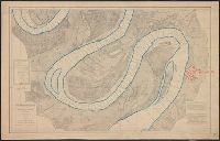
- Creator:
- United States. Mississippi River Commission
- Published / Created:
- 1879-
- Call Number:
- BrSides Double Folio 2018 85
- Image Count:
- 1
- Resource Type:
- Maps, Atlases & Globes
- Found in:
- Beinecke Rare Book and Manuscript Library > Survey of the Mississippi River / made under the direction of the Mississippi River Commission.
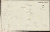
- Creator:
- Imray, James F. (James Frederick), 1829?-1891, cartographer
James Imray and Son, issuing body
- Call Number:
- 23cea 1886
- Container / Volume:
- BRBL_00021
- Image Count:
- 2
- Resource Type:
- Maps, Atlases & Globes
- Found in:
- Beinecke Rare Book and Manuscript Library > Western Pacific. Chart No. 2 / compiled by James F. Imray F.R.G.S.
- Creator:
- Imray, James F. (James Frederick), 1829?-1891, author
James Imray and Son, publisher
- Call Number:
- 23cea 1884
- Container / Volume:
- BRBL_00021
- Image Count:
- 2
- Resource Type:
- Maps, Atlases & Globes
- Found in:
- Beinecke Rare Book and Manuscript Library > South and east coasts of Australia [in four charts]. Chart no. 2, Cape Northumberland to Cape Howe / compiled by James F. Imray F.R.G.S.
- Published / Created:
- 1945]
- Call Number:
- 11hd 1945H
- Container / Volume:
- BRBL_00010ZF
- Image Count:
- 2
- Resource Type:
- Maps, Atlases & Globes
- Found in:
- Beinecke Rare Book and Manuscript Library > Japan, Honshu - South Coast : Iseno Umi or Ise Wan and Mikawa Wan with approaches, from Japanese surveys to 1927, with additions to 1935.
- Creator:
- James Imray and Son
- Published / Created:
- 1864
- Call Number:
- 23cea 1864
- Container / Volume:
- BRBL_00021
- Image Count:
- 3
- Resource Type:
- Maps, Atlases & Globes
- Found in:
- Beinecke Rare Book and Manuscript Library > Western Pacific : Australia to China / James Imray and Son.
- Creator:
- Halley, Edmond, 1656-1742
- Published / Created:
- 1700
- Call Number:
- 11 1700
- Container / Volume:
- BRBL_00004
- Image Count:
- 1
- Resource Type:
- Maps, Atlases & Globes
- Found in:
- Beinecke Rare Book and Manuscript Library > Nova & accuratissima totius terrarum orbis tabula nautica, variationum magneticarum index juxta observationes anno. 1700 ... / per Edm: Halley ; I Harris sculp. = A new and correct sea chart of the whole world shewing the variations of the compass as they
- Creator:
- Lucas, Fielding, 1781-1854
Warr, John, b. ca. 1798
Warr, William W
- Published / Created:
- [1862], c1852
- Call Number:
- 21cea 1862
- Image Count:
- 1
- Resource Type:
- Maps, Atlases & Globes
- Found in:
- Beinecke Rare Book and Manuscript Library > A chart of the Chesapeake and Delaware Bays / compiled and published by Fielding Lucas.
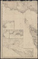
- Creator:
- Faden, William, 1749-1836
Palmer, W. (William), 1739-1812
Roberts, Henry, Lieut
- Published / Created:
- 1784
- Call Number:
- 23 1784
- Container / Volume:
- BRBL_00019
- Image Count:
- 1
- Resource Type:
- Maps, Atlases & Globes
- Found in:
- Beinecke Rare Book and Manuscript Library > Chart of the N.W. coast of America and the N.E. coast of Asia, explored in the years 1778 and 1779 / prepared by Lieut. Heny. Roberts, under the immediate inspection of Capt. Cook ; engraved by W. Palmer.