The description of this slide reflects the way that Erdoes organized 35mm slides. Erdoes arranged his slides in labeled containers that were sub-divided into labeled sections. The title for this image has been transcribed from its sub-section label; images of other slides from the same sub-section share the container title. The date listed here reflects a span of known dates associated the sub-section. In some cases, titles have been expanded to note particular individuals who appear frequently and who were identified by Erdoes in captions. Individual slide captions have not been transcribed or captured during digitization.
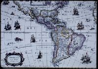
Subject (Geographic):
North America--Maps--Early works to 1800 and South America--Maps--Early works to 1800
Pine, John, 1690-1756 Rocque, John, d. 1762 Tinney, John
Published / Created:
1746
Call Number:
2002 Folio 94
Image Count:
1
Resource Type:
Maps, Atlases & Globes
Alternative Title:
Contracted sketch of the plan of London &c. and Plan of the cities of London and Westminster and borough of Southwark.
Description:
"Published in October 1746 ... ", An index map to accompany Rocque's A plan of the cities of London and Westminster and borough of Southwark., Maps in volume are tab mounted., and Title from no. 1 of 7 works (comprising 45 maps) bound together in a vol. with hand-lettered dust jacket with ms. title, "Rocques map of London, 1746,"and autograph of Ralph Hodgson.
The description of this slide reflects the way that Erdoes organized 35mm slides. Erdoes arranged his slides in labeled containers that were sub-divided into labeled sections. The title for this image has been transcribed from its sub-section label; images of other slides from the same sub-section share the container title. The date listed here reflects a span of known dates associated the sub-section. In some cases, titles have been expanded to note particular individuals who appear frequently and who were identified by Erdoes in captions. Individual slide captions have not been transcribed or captured during digitization.
Subject (Geographic):
Mexico City (Mexico)--History--Maps, Mexico --History --Conquest, 1519-1540--Pictorial works, and Tenochtitla?n (Mexico)--Pictorial works
Subject (Name):
Aztecs--History--Pictorial works, Corte?s, Herna?n, 1485-1547, and Montezuma II, Emperor of Mexico, ca. 1480-1520
Map of San Francisco imperfect: torn along fold at upper right., Maps linen backed and bound in on tabs., Numerous pagination errors., and Printer’s dummy[?] with printed title page and "avant propos." Text consists of mounted newspaper clippings[?] and original illustrations in pencil and watercolor as well as several prints (from other sources) and two hand drawn and colored maps of San Francisco and Northern California.
Publisher:
Imp. Comm. (Margritat G., Dr)
Subject (Geographic):
California--Maps, Manuscript and San Francisco (Calif.)--Maps, Manuscript
Subject (Topic):
California --Gold discoveries and Voyages to the Pacific coast