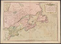
Appears in Laurie & Whittle's New and elegant imperial sheet atlas., Hand col. Sheet measures 54.5 x 73.6 cm. Stamp: Yale Horace Brown 1900S., Includes note., Prime meridian: London., Relief shown pictorially., and Shows boundaries of states.
Publisher:
Publish'd by Laurie & Whittle, 53 Fleet Street,
Subject (Geographic):
Canada--Maps--Early works to 1800, Great Britain--Colonies--America--Maps--Early works to 1800, and Northeastern States--Maps--Early works to 1800
Subject (Name):
Robert Laurie and James Whittle and Robert Laurie and James Whittle. New and elegant imperial sheet atlas
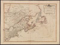
Appears in Laurie & Whittle's New and elegant imperial sheet atlas., Hand col. Sheet measures 52.5 x 72.4 cm. Ms. no. on verso: 62. Stamp on verso: Yale Horace Brown 1900S., Includes note., Prime meridian: London., Relief shown pictorially., and Shows b
Publisher:
Publish'd by Laurie & Whittle, 53 Fleet Street,
Subject (Geographic):
Canada--Maps--Early works to 1800, Great Britain--Colonies--America--Maps--Early works to 1800, and Northeastern States--Maps--Early works to 1800
Subject (Name):
Robert Laurie and James Whittle and Robert Laurie and James Whittle. New and elegant imperial sheet atlas
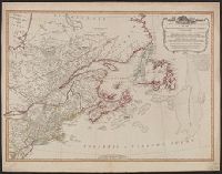
Appears in Laurie & Whittle's New and elegant imperial sheet atlas., Hand col. Sheet measures 53.8 x 72.1 cm. Ms. no. on verso: 66. Cross Collection no. 158., Includes note., Prime meridian: London., Relief shown pictorially., and Shows boundaries of states.
Publisher:
Publish'd by Laurie & Whittle, 53 Fleet Street,
Subject (Geographic):
Canada--Maps--Early works to 1800, Great Britain--Colonies--America--Maps--Early works to 1800, and Northeastern States--Maps--Early works to 1800
Subject (Name):
Robert Laurie and James Whittle and Robert Laurie and James Whittle. New and elegant imperial sheet atlas
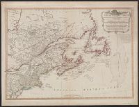
Appears in Laurie & Whittle's New and elegant imperial sheet atlas., Copy 1: Hand col. Sheet measures 54.3 x 69.8 cm. Franklin Collection no. 131 1794 18., Includes note., Prime meridian: London., Relief shown pictorially., and Shows boundaries of states.
Publisher:
Publish'd by Laurie & Whittle, 53 Fleet Street,
Subject (Geographic):
Canada--Maps--Early works to 1800, Great Britain--Colonies--America--Maps--Early works to 1800, and Northeastern States--Maps--Early works to 1800
Subject (Name):
Robert Laurie and James Whittle and Robert Laurie and James Whittle. New and elegant imperial sheet atlas
Appears in Laurie & Whittle's New and elegant imperial sheet atlas., Copy 2: Hand col. Sheet measures 54.3 x 70.9 cm. Ms. no. on verso: 62. Franklin Collection no. 131 1794 19., Includes note., Prime meridian: London., Relief shown pictorially., and Shows boundaries of states.
Publisher:
Publish'd by Laurie & Whittle, 53 Fleet Street,
Subject (Geographic):
Canada--Maps--Early works to 1800, Great Britain--Colonies--America--Maps--Early works to 1800, and Northeastern States--Maps--Early works to 1800
Subject (Name):
Robert Laurie and James Whittle and Robert Laurie and James Whittle. New and elegant imperial sheet atlas