Search
You Searched For
Search Results
- Creator:
- George B. Cadwell & Co
- Published / Created:
- 1893
- Call Number:
- 811 M815 1893
- Container / Volume:
- BRBL_00553
- Image Count:
- 1
- Resource Type:
- Maps, Atlases & Globes
- Description:
- Lenawee County, Michigan. [Adrian, Mich
- Publisher:
- Geo. B. Cadwell & Co.,
- Subject (Geographic):
- Morenci (Mich.)--Maps
- Subject (Name):
- Lenawee County, Michigan
- Subject (Topic):
- Real property--Michigan--Morenci--Maps
- Found in:
- Beinecke Rare Book and Manuscript Library > Morenci : compiled & drawn expressly for the Lenawee County atlas.
- Creator:
- Winchell, Alexander, 1824-1891
- Published / Created:
- 1865
- Call Number:
- 811 1865
- Container / Volume:
- BRBL_00552
- Image Count:
- 1
- Resource Type:
- Maps, Atlases & Globes
- Description:
- Inset map showing state of Michigan and
- Publisher:
- Sage Sons & Co. lith.,
- Subject (Geographic):
- Grand Traverse Bay Region (Mich.)--Maps
- Subject (Name):
- Rothwell, H. G. (Harry G.) and Sage Sons & Co
- Subject (Topic):
- Geology--Michigan--Grand Traverse Bay
- Found in:
- Beinecke Rare Book and Manuscript Library > Map of the Grand Traverse region : to accompany a report on its geological & industrial resources / by Alexander Winchell ; drawn by H.G. Rothwell.
- Published / Created:
- 1843
- Call Number:
- 811 1843
- Container / Volume:
- BRBL_00552
- Image Count:
- 1
- Resource Type:
- Maps, Atlases & Globes
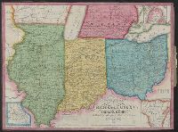
- Description:
- Insets: 1. Missouri 2. Wisconsin Tery.
- Publisher:
- Humphrey Phelps & T. Ensign,
- Subject (Geographic):
- Michigan--Maps
- Found in:
- Beinecke Rare Book and Manuscript Library > Traveller's map of Michigan, Indiana & Ohio.
- Published / Created:
- [1847]
- Call Number:
- 811fcm 1847
- Container / Volume:
- BRBL_00554
- Image Count:
- 1
- Resource Type:
- Maps, Atlases & Globes
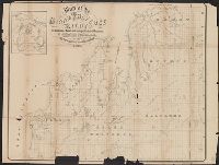
- Description:
- Designated "E" above title. and Preliminary record.
- Subject (Geographic):
- Michigan--Maps
- Found in:
- Beinecke Rare Book and Manuscript Library > Sketch of the Public Surveys in Michigan.
- Published / Created:
- 1837
- Call Number:
- 811 1837
- Container / Volume:
- BRBL_00552
- Image Count:
- 1
- Resource Type:
- Maps, Atlases & Globes
- Description:
- Engraved by S. Stiles & Co., New York. and Sections colored by hand.
- Publisher:
- J.H. Colton & Co.,
- Subject (Geographic):
- Michigan--Maps
- Found in:
- Beinecke Rare Book and Manuscript Library > The Surveyed Part of Michigan by John Farmer.
- Published / Created:
- 1880
- Call Number:
- 811 1880
- Container / Volume:
- BRBL_00552
- Image Count:
- 1
- Resource Type:
- Maps, Atlases & Globes
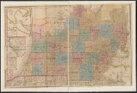
- Description:
- Ms. notes upper and lower right corners.
- Publisher:
- Geo. F. Cram,
- Subject (Geographic):
- Michigan--Maps
- Found in:
- Beinecke Rare Book and Manuscript Library > Railroad map of Michigan / prepared for the Commissioner of railroads.
- Published / Created:
- 1836
- Call Number:
- 811 1836
- Container / Volume:
- BRBL_00552
- Image Count:
- 1
- Resource Type:
- Maps, Atlases & Globes
- Description:
- Largest inset: Map of the Straits of Michillimackinac.
- Publisher:
- J.H. Colton,
- Subject (Geographic):
- Michigan--Maps
- Found in:
- Beinecke Rare Book and Manuscript Library > An improved edition of a map of the survryed part of the Territory of Michigan. by John Farmer
- Creator:
- Roser, C
- Published / Created:
- 1878
- Call Number:
- 811 1878
- Container / Volume:
- BRBL_00552
- Image Count:
- 1
- Resource Type:
- Maps, Atlases & Globes
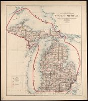
- Description:
- At head of title: Department of the Interior. General Land Office. J.A. Williamson, Commissioner. and Greenwich and Washington prime meridians.
- Publisher:
- Lithographed & printed by Julius Bien,
- Subject (Geographic):
- Michigan--Maps
- Subject (Name):
- United States. General Land Office and Williamson, J
- Found in:
- Beinecke Rare Book and Manuscript Library > State of Michigan / compiled from the official records of the General Land Office and other sources by C. Roser, principal draughtsman G.L.O.
- Creator:
- George B. Cadwell & Co
- Published / Created:
- 1892
- Call Number:
- 811 T227 1892
- Container / Volume:
- BRBL_00553
- Image Count:
- 1
- Resource Type:
- Maps, Atlases & Globes
- Description:
- Cadastral map.
- Publisher:
- Geo. B. Cadwell & Co.],
- Subject (Geographic):
- Tecumseh (Mich.)--Maps
- Subject (Name):
- Lenawaee County, Michigan
- Subject (Topic):
- Real property--Michigan--Tecumseh--Maps
- Found in:
- Beinecke Rare Book and Manuscript Library > Map of Tecumseh : compiled for Geo. B. Cadwell & Co's. atlas of Lenawee County, Mich.
- Creator:
- United States. General Land Office
- Published / Created:
- 1904
- Call Number:
- 811 1904L
- Container / Volume:
- BRBL_00552
- Image Count:
- 1
- Resource Type:
- Maps, Atlases & Globes
- Description:
- At head of title: Department of the Interior, General Land Office, William A. Richards, Commissioner. and Shows status of surveys and land offices.
- Publisher:
- The Office,
- Subject (Geographic):
- Michigan--Maps
- Subject (Name):
- Bond, Frank and Helm, Charles J
- Found in:
- Beinecke Rare Book and Manuscript Library > State of Michigan / compiled from the official records of the General Land Office and other sources Under the direction of Frank Bond, Chief of Drafting Division, G.L.O. ; revised and drawn by Charles J. Helm.