Appears in 1590 and 1682 eds. of Theatrum terrae., Laor contributes this map to Christian van Adrichom in Cologne, ca. 1590., Oriented to the east., Relief shown pictorially., and Shows portion of the Holy Land given to the Tribe of Reuben at the time of the divi
Publisher:
Birckmannica,
Subject (Geographic):
Palestine--History--To 70 A.D.--Maps and Palestine--Maps--Early works to 1800
Subject (Name):
Adrichem, Chirstiaan van, 1533-1585. Theatrum Terrae Sanctae and Birckmann, Johann, 1527-1572
Decorated with sea monsters, mermaids, exotic animals, and cannibals, this wood cut map provides a marked contrast to the simplistic diagrams considered the earliest printed world maps. While the latter presented a world view based in Judeo-Christian theo
Alternative Title:
Typus cosmographicus universalis and Typvs cosmographicvs vniversalis
Description:
Appears in Johann Huttich's Novus orbis regionum. Basel. 1532. and Relief shown pictorially.
Publisher:
[publisher not identified],
Subject (Name):
Holbein, Hans, 1497-1543 and Huttich, Johann, 1480?-1544. Novus orbis regionum.
Afheeldinghe der custen des landts Guinea, Manicongo, ende Angôla, ende voorts tot voorby de C. de boa esperança and Delineatio orarum maritimarum, terrae vulgo indigetatae terra do Natal item Sofalae, Mozambicae & Melindae ...
Description:
Appears in the author's, Companion map to Delineatio orarum maritimarum, terrae vulgo indigetatae terra do Natal item Sofalae, Mozambicae & Melindae ..., Has watermark., Relief shown pictorially., and Title in Latin and Dutch. Place names in Latin and Portuguese.
Publisher:
Arnold Florent van Langren,
Subject (Geographic):
Africa, Southern--Maps--Early works to 1800
Subject (Name):
Langren, Arnold Florent van, 1580-1644 and Linschoten, Jan Huygen van, 1563-1611. Itinerario, voyage ofte schipvaert van Jan Huygen van Linschoten naer Oost ofte Portugaels Indien
Subject (Topic):
Coasts--Africa, Southern--Maps--Early works to 1800
Afheeldinghe der custen des landts Guinea, Manicongo, ende Angôla, ende voorts tot voorby de C. de boa esperança and Delineatio orarum maritimarum, terrae vulgo indigetatae terra do Natal item Sofalae, Mozambicae & Melindae ...
Description:
Appears in the author's Itinerario, voyage ofte schipvaert van Jan Huygen van Linschoten naer Oost ofte Portugaels Indien., Includes views of Ascension Island and Sain, Relief shown pictorially., and Title in Latin and Dutch. Place names in Latin and Portuguese.
Publisher:
Arnold Florent van Langren,
Subject (Geographic):
Africa, Southern--Maps--Early works to 1800
Subject (Name):
Langren, Arnold Florent van, 1580-1644 and Linschoten, Jan Huygen van, 1563-1611. Itinerario, voyage ofte schipvaert van Jan Huygen van Linschoten naer Oost ofte Portugaels Indien
Subject (Topic):
Coasts--Africa, Southern--Maps--Early works to 1800
Possibly from Münster's 1545 edition of Ptolemy's Geographia [Basel : Heinrich Petri, 1545]. and Sheet measures 31.5 x 39 cm. Stamp on verso: Karpinski-von Wieser Map Collection.
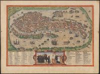
"Cvm privilegio"., From Braun and Hogenberg's Civitates orbis terrarum, 1572., Includes index of city features and a depiction of Venetian figures., Latin, Italian., No. on verso: 43., Relief shown pictorially., and Sheet measures 40 x 54 cm. Ms. note on verso. dgv
Publisher:
s.n.,
Subject (Geographic):
Venice (Italy)--Maps--Early works to 1800
Subject (Name):
Hogenberg, Frans, approximately 1539-1590. Civitates Orbis Terrarum. Latin
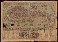
"Cvm privilegio"., Copy 2: Imperfect: Mutilated with loss of information. Hand colored., From Braun and Hogenberg's Civitates orbis terrarum, 1572., Includes index of city features and a depiction of Venetian figures., Latin, Italian., No. on verso: 43., and Relief shown pictorially.
Publisher:
s.n.,
Subject (Geographic):
Venice (Italy)--Maps--Early works to 1800
Subject (Name):
Hogenberg, Frans, approximately 1539-1590. Civitates Orbis Terrarum. Latin
Gastaldi, Giacomo, approximately 1500-approximately 1565
Published / Created:
[1897]
Call Number:
11 1546
Image Count:
1
Resource Type:
Maps, Atlases & Globes
Alternative Title:
Remarkable maps of the XVth, XVIth and XVIIth centuries ; pt. 4, no. 8., Reproductions of geographical maps ; [pt. 4, no. 8], and Universale
Description:
Facsimile., Relief shown pictorially., Series title commonly cited as Remarkable maps of the XVth, XVIth and XVIIth centuries., and World map on an oval projection.
Publisher:
Frederik Muller,
Subject (Topic):
Early maps, Early maps--Facsimiles, World maps, and World maps--Early works to 1800--Facsimiles