Skip to search
Skip to main content
Skip to first result
Search
You Searched For
Extent of Digitization
Completely digitized
Repository
Beinecke Rare Book and Manuscript Library
Genre
Maps
Subject (Name)
Arnold, Robert M.--Ownership
New Search
Search Results
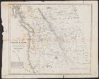
Creator:
Published / Created:
1838]
Call Number:
80 1838B
Container / Volume:
BRBL_00532
Image Count:
1
Resource Type:
Maps, Atlases & Globes
Found in:
Beinecke Rare Book and Manuscript Library > Map of the United States, Territory of Oregon, west of the Rocky Mountains : exhibiting the various trading depots or forts occupied by the British Hudson Bay Company, connected with the western and northwestern fur trade / compiled in the Bureau of Topog
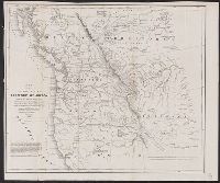
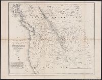
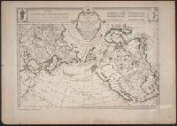
Creator:
Published / Created:
[1752]
Call Number:
23 1750
Container / Volume:
BRBL_00682
Image Count:
1
Resource Type:
Maps, Atlases & Globes
Found in:
Beinecke Rare Book and Manuscript Library > Carte des nouvelles découvertes au nord de la Mer du Sud : tant à l'est de la Siberie et du Kamtchatka, qu'à l'ouest de la Nouvelle France / dressée sur le mémoires de Mr. Del'Isle, professeur royal et de l'Académie des sciences par Philippe Buache
Creator:
Published / Created:
[between 1635 and 1650]
Call Number:
11 1635
Container / Volume:
BRBL_00003
Image Count:
2
Resource Type:
Maps, Atlases & Globes
Found in:
Beinecke Rare Book and Manuscript Library > Nova totius terrarum orbis geographica ac hydrographica tabula / auct. Guiljelmo Blaeuw ; Ja. van den Ende sculpsit.
Creator:
Published / Created:
1798
Call Number:
845 1798E
Container / Volume:
BRBL_00619
Image Count:
1
Resource Type:
Maps, Atlases & Globes
Found in:
Beinecke Rare Book and Manuscript Library > A chart shewing part of the coast of N.W. America, with the tracks of His Majesty's sloop Discovery and armed tender Chatham / commanded by George Vancouver, esqu. and prepared under his immediate inspection by Lieut. Joseph Baker, in which the continenta
Creator:
Published / Created:
1798
Call Number:
845 1798B
Container / Volume:
BRBL_00619
Image Count:
1
Resource Type:
Maps, Atlases & Globes
Found in:
Beinecke Rare Book and Manuscript Library > A chart shewing part of the coast of N.W. America, with the tracks of His Majesty's sloop Discovery and armed tender Chatham / commanded by George Vancouver, esqr. and prepared from the foregoing surveys under his immediate inspection by Lieut. Edwd. Robe
Creator:
Published / Created:
1798
Call Number:
845 1798C
Container / Volume:
BRBL_00619
Image Count:
1
Resource Type:
Maps, Atlases & Globes
Found in:
Beinecke Rare Book and Manuscript Library > A chart shewing part of the coast of N.W. America, with the tracks of His Majesty's sloop Discovery and armed tender Chatham / commanded by George Vancouver, esq. and prepared under his immediate inspection by Lieut. Joseph Baker, in which the continental
Creator:
Published / Created:
1798
Call Number:
845 1798G
Container / Volume:
BRBL_00619
Image Count:
1
Resource Type:
Maps, Atlases & Globes
Found in:
Beinecke Rare Book and Manuscript Library > A chart shewing part of the coast of N.W. America, with the tracks of His Majesty's sloop Discovery and armed tender Chatham / commanded by George Vancouver, esqr. and prepared under his immediate inspection by Lieut. Joseph Baker, in which the continenta
Creator:
Published / Created:
1798
Call Number:
845 1798A
Container / Volume:
BRBL_00619
Image Count:
1
Resource Type:
Maps, Atlases & Globes
Found in:
Beinecke Rare Book and Manuscript Library > A chart shewing part of the coast of N.W. America : with the tracks of His Majesty's sloop Discovery and armed tender Chatham / commanded by George Vancouver, esqr. and prepared under his immediate inspection by Lieut. Joseph Baker, in which the continent
Branch:v1.60.98 ,Deployed:2024-04-24T10:14:36-04:00