Search
You Searched For
Search Results
- Call Number:
- 766 N46 1917
- Container / Volume:
- BRBL_00473A
- Image Count:
- 15
- Resource Type:
- Maps, Atlases & Globes
- Found in:
- Beinecke Rare Book and Manuscript Library > [City of New Haven] 1913-1917.
- Creator:
- Woerl, Joseph Edmund, creator
- Call Number:
- 37 1835
- Container / Volume:
- BRBL_00148
- Image Count:
- 19
- Resource Type:
- Maps, Atlases & Globes
- Found in:
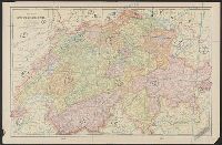
- Beinecke Rare Book and Manuscript Library > Karte der Schweiz / von Dr. I. Woerl.
- Creator:
- Månsson, Johan, -1659
- Call Number:
- Double Covers 303cea +1645
- Image Count:
- 7
- Resource Type:
- Maps, Atlases & Globes
- Found in:
- Beinecke Rare Book and Manuscript Library > [Chart of the Baltic Sea] / Siegismuntlus von Vogell fecit.
- Call Number:
- WA MSS S-2670
- Collection Title:
- Peter Palmquist collection of Humboldt County, California, male photographers
- Container / Volume:
- Box 64 | Folder 7
- Image Count:
- 46
- Resource Type:
- Prints & Photographs
- Found in:
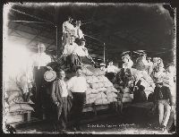
- Beinecke Rare Book and Manuscript Library > Freeman Art Co.
- Call Number:
- WA MSS 443
- Collection Title:
- Isaac Ingalls Stevens papers
- Container / Volume:
- Box 2 | Folder 29
- Image Count:
- 51
- Resource Type:
- Archives or Manuscripts
- Found in:
- Beinecke Rare Book and Manuscript Library > [Delacy, Walter Washington]
- Creator:
- Rhode, Johann Christoph, cartographer
- Call Number:
- 755 1755AA
- Container / Volume:
- BRBL_00427
- Image Count:
- 1
- Resource Type:
- Maps, Atlases & Globes
- Found in:
- Beinecke Rare Book and Manuscript Library > Theatrum belli in America Septentrionali / II. foliis comprehensum jussu Acad. Reg. Scient. et Eleg. Litt. exhibet I. C. Rhode Ac: Geogr. ; Berger, sculpsit berol.
- Creator:
- Robert Sayer and John Bennett (Firm)
- Call Number:
- 755 1776K
- Container / Volume:
- BRBL_00430
- Image Count:
- 1
- Resource Type:
- Maps, Atlases & Globes
- Found in:
- Beinecke Rare Book and Manuscript Library > A general map of the northern British colonies in America : which comprehends the province of Quebec, the government of Newfoundland, Nova-Scotia, New-England and New-York, from the maps published by the Admiralty and Board of Trade, regulated by the astr
- Call Number:
- 3369 1839
- Container / Volume:
- BRBL_00089
- Image Count:
- 1
- Resource Type:
- Maps, Atlases & Globes
- Found in:
- Beinecke Rare Book and Manuscript Library > Croquis annexè á la note relative á Martelange.
- Creator:
- Mortier, Pierre, author
- Call Number:
- 462 1721
- Container / Volume:
- BRBL_00260
- Image Count:
- 1
- Resource Type:
- Maps, Atlases & Globes
- Found in:
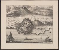
- Beinecke Rare Book and Manuscript Library > Castell-novo : aux Venetiens dans le Dalmatie / par Pierre Mortier.
- Creator:
- Güldenstädt, Johann Anton, 1745-1781, author
- Call Number:
- 494 1776
- Container / Volume:
- BRBL_00270
- Image Count:
- 1
- Resource Type:
- Maps, Atlases & Globes
- Found in:
- Beinecke Rare Book and Manuscript Library > Carte de la Mer Caspienne : dressée en 7bre 1776 d'après les dernieres observations / par D. Guldenstaedt ; gravé par P.F. Tardieu.
- Call Number:
- 11hcf 1919-53
- Container / Volume:
- BRBL_00010L
- Image Count:
- 1
- Resource Type:
- Maps, Atlases & Globes
- Found in:
- Beinecke Rare Book and Manuscript Library > Map of the Adriatic Sea and surrounding countries showing territorial demarcations based on Treaty of London, 1915.
- Call Number:
- 40 1860B
- Container / Volume:
- BRBL_00201
- Image Count:
- 1
- Resource Type:
- Maps, Atlases & Globes
- Found in:
- Beinecke Rare Book and Manuscript Library > Carte routiere des differents passages des Alpes et du Piemont = Carta postale dei diversi passaggi delle Alpi e del Piemonte.
- Creator:
- Tardieu, P. F. (Pierre François), 1757-1822, author
- Call Number:
- 451 1785
- Container / Volume:
- BRBL_00258
- Image Count:
- 1
- Resource Type:
- Maps, Atlases & Globes
- Found in:
- Beinecke Rare Book and Manuscript Library > Plan de la bataille & de la victoire remporteé par les Russes sur les Turcs commandés par le Grand Visir près de la riviere Kagul en Bessarabie, le 21 Juillet, 1770 / gravé par P.F. Tardieu.
- Creator:
- Tardieu, P. F. (Pierre François), 1757-1822, author
- Call Number:
- 45 1785
- Container / Volume:
- BRBL_00258
- Image Count:
- 1
- Resource Type:
- Maps, Atlases & Globes
- Found in:
- Beinecke Rare Book and Manuscript Library > Plan des Expéditions faites par le Gal. Weissman de l'autre côté du Danube contre Tultschi & Isaktschi / gravé par P.F. Tardieu.
- Creator:
- Ukert, F. A. (Friedrich August), 1780-1851
- Call Number:
- 390 1820
- Container / Volume:
- BRBL_00192
- Image Count:
- 1
- Resource Type:
- Maps, Atlases & Globes
- Found in:
- Beinecke Rare Book and Manuscript Library > Hispania.
- Creator:
- Tardieu, P. F. (Pierre François), 1757-1822, author
- Call Number:
- 451 1770
- Container / Volume:
- BRBL_00258
- Image Count:
- 1
- Resource Type:
- Maps, Atlases & Globes
- Found in:
- Beinecke Rare Book and Manuscript Library > Bender : assiege & pris par les Russes en 1770 / gravé par P.F. Tardieu.
- Creator:
- Tardieu, P. F. (Pierre François), 1757-1822, author
- Call Number:
- 45 1771
- Container / Volume:
- BRBL_00258
- Image Count:
- 1
- Resource Type:
- Maps, Atlases & Globes
- Found in:
- Beinecke Rare Book and Manuscript Library > Plan de l'Attaque du Retranchement, du Camp, et de la Flotte des Turcs par le Gal. Weisman, près de Tultschi, le 30 Juin 1771 / gravé par P.F. Tardieu.
- Creator:
- Tardieu, P. F. (Pierre François), 1757-1822, author
- Call Number:
- 3543 1785
- Container / Volume:
- BRBL_00113
- Image Count:
- 1
- Resource Type:
- Maps, Atlases & Globes
- Found in:
- Beinecke Rare Book and Manuscript Library > Tereki Fluvii Cursus, Kabarda major minor-que, et Caucaso adjacentes regiones / gravé par P.F. Tardieu.
- Creator:
- Blaeu, Willem Janszoon, 1571-1638, cartographer
- Call Number:
- 33 1635
- Container / Volume:
- BRBL_00077
- Image Count:
- 1
- Resource Type:
- Maps, Atlases & Globes
- Found in:
- Beinecke Rare Book and Manuscript Library > Novus XVII inferioris Germaniae provinciarum typus / de integro multis in locis emendatus à Guliel. Ianssonio ; Josua van den Ende, sculpsit.
- Call Number:
- 771hc B796 1776A
- Container / Volume:
- BRBL_00495
- Image Count:
- 1
- Resource Type:
- Maps, Atlases & Globes
- Found in:
- Beinecke Rare Book and Manuscript Library > [Map of Brooklyn, N.Y., showing the battle in this area in 1776, superimposed upon a modern street map.]