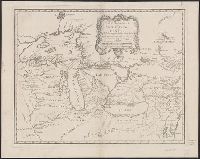
Covers the area from Lake Superior to Kaskaskia and from Delaware Bay to the Mississippi River., Relief shown pictorially., Shows a few towns, missions, forts, Indian villages and tribal territory, rivers and lakes, portages, and early place-names., and Watermark.
Publisher:
[Homann Erben?],
Subject (Geographic):
Canada--Maps--Early works to 1800, Great Lakes Region (North America)--Maps--Early works to 1800, and New France--Maps--Early works to 1800
Subject (Name):
Brown, Horace--Stamp, Homann Erben (Firm), and Thorne Collection of Cartogaphy and Geography Stamp
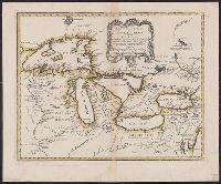
Copy 1: Borders of lakes and frame of map colored in yellow. Backed with linen. Stamp: Thorne Collection of Cartography and Geography. Stamp: Karpinski-von Wieser Map Collection., Covers the area from Lake Superior to Kaskaskia and from Delaware Bay to the Mississippi River., Relief shown pictorially., Shows a few towns, missions, forts, Indian villages and tribal territory, rivers and lakes, portages, and early place-names., and Watermark.
Publisher:
[Homann Erben?],
Subject (Geographic):
Canada--Maps--Early works to 1800, Great Lakes Region (North America)--Maps--Early works to 1800, and New France--Maps--Early works to 1800
Subject (Name):
Homann Erben (Firm) and Thorne Collection of Cartogaphy and Geography Stamp