Search
You Searched For
Search Results
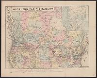
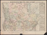
- Creator:
- National Railway Publication Company
- Call Number:
- 71gme 1870
- Container / Volume:
- BRBL_00372
- Image Count:
- 1
- Resource Type:
- Maps, Atlases & Globes
- Found in:
- Beinecke Rare Book and Manuscript Library > Map of the Northern Pacific Railway and tributary country.
- Creator:
- Burr, Henry A
- Published / Created:
- 1853
- Call Number:
- 75GM 1853
- Container / Volume:
- BRBL_00410
- Image Count:
- 1
- Resource Type:
- Maps, Atlases & Globes
- Found in:
- Beinecke Rare Book and Manuscript Library > Disturnell's new map of the United States and Canada : showing all the canals, rail roads, telegraph lines and principal stage routes / Drawn by Henry A. Burr.
- Creator:
- Middleton, Strobridge & Co
- Published / Created:
- [1857].
- Call Number:
- 753gme 1858
- Container / Volume:
- BRBL_00415
- Image Count:
- 1
- Resource Type:
- Maps, Atlases & Globes
- Found in:
- Beinecke Rare Book and Manuscript Library > Map illustrating the Canada Pacific and Northern Pacific and other proposed Railroads, connecting at Straits of Mackinaw : Also showing the position of Mackinaw City.
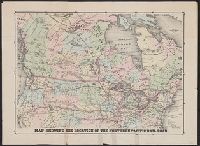
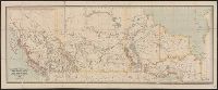
- Published / Created:
- [1870?]
- Call Number:
- 75gme 1870
- Container / Volume:
- BRBL_00412
- Image Count:
- 1
- Resource Type:
- Maps, Atlases & Globes
- Found in:
- Beinecke Rare Book and Manuscript Library > Map showing the location of the Northern Pacific Rail Road.
- Creator:
- National Railway Publication Company
- Published / Created:
- [187-?]
- Call Number:
- 71gme 1875
- Container / Volume:
- BRBL_00372
- Image Count:
- 1
- Resource Type:
- Maps, Atlases & Globes
- Found in:
- Beinecke Rare Book and Manuscript Library > Map of the Northern Pacific R.R., its connections and tributary country.
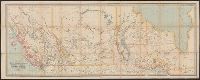
- Published / Created:
- [1870?]
- Call Number:
- 75gme 1870
- Container / Volume:
- BRBL_00372
- Image Count:
- 1
- Resource Type:
- Maps, Atlases & Globes
- Found in:
- Beinecke Rare Book and Manuscript Library > Map showing the location of the Northern Pacific Rail Road.
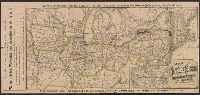
- Creator:
- National Railway Publication Company
- Published / Created:
- [1872?]
- Call Number:
- 71gme 1872
- Container / Volume:
- BRBL_00372
- Image Count:
- 1
- Resource Type:
- Maps, Atlases & Globes
- Found in:
- Beinecke Rare Book and Manuscript Library > Map of the Northern Pacific Railroad and tributary country.
- Creator:
- Dawson Brothers
- Published / Created:
- 1880
- Call Number:
- 73 1880
- Container / Volume:
- BRBL_00375
- Image Count:
- 1
- Resource Type:
- Maps, Atlases & Globes
- Found in:
- Beinecke Rare Book and Manuscript Library > Map of Manitoba, Kewaydin, British Columbia and North West Territory : shewing the country traversed by the Canadian Pacific Railway.
- Creator:
- Dawson Brothers
- Published / Created:
- 1882
- Call Number:
- 73 1882
- Container / Volume:
- BRBL_00375
- Image Count:
- 1
- Resource Type:
- Maps, Atlases & Globes
- Found in:
- Beinecke Rare Book and Manuscript Library > Map of Manitoba, Kewaydin, British Columbia and North West Territory : shewing the country traversed by the Canadian Pacific Railway.
- Creator:
- Matthews-Northrup Company
- Published / Created:
- [1885?].
- Call Number:
- 75gme 1885B
- Container / Volume:
- BRBL_00414
- Image Count:
- 2
- Resource Type:
- Maps, Atlases & Globes
- Found in:
- Beinecke Rare Book and Manuscript Library > Map of the New York Central and Hudson River Railroad and its connections / Wm. P. Northrup & Co., Map Engravers, Buffalo, N.Y.