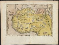
Qazwīnī, Zakarīyā ibn Muḥammad, 1208 or 9-1283 or 4.
Published / Created:
[15--?]
Call Number:
Arabic MSS 575
Image Count:
2
Resource Type:
Maps, Atlases & Globes
Abstract:
In the center of the map is Mecca; the ocean is located on each side along the outer edge of the sheet with the pillars of the earth in the four corners. Great emphasis is placed on Africa and the Nile river. Other places of interest include: Wasteland where nobody lives, Mountains of the Moon, Land of the Slavs and Franks, Gog and Magog, Land of the Turks (Central Asia), Red Sea (rectangular water mass), the Source of life.
Description:
Gift of Thomas E. Marston, Yale '27, in honor of Alexander O. Vietor, Yale '36, in November 1978., Removed from a bound volume., and Tempera and ink.
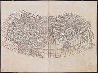
Cordiform projection., From: "Claudii Ptholemaei Alexandrini liber geographiae cum tabulis...", From: Clavdii Ptholemaei Alexandrini Liber geographiae cvm tabvlis...1511., Lanman collection; dgvmp2008., Map is printed in two colors, red and black., Outer map border shows decorative windheads and zodiacal signs., The author's name is often given as Bernard Sylvanus (see Shirley entry 32, plate 35) or Bernardus Sylvanus., and Title supplied by cataloger.
Publisher:
Per Iacobum Pentium de Leucho,
Subject (Name):
Pencio, Jacopo, active 1486-1530 and Ptolemy, active 2nd century. Geographia
Cordiform projection., From Claudii Ptholemaei Alexandrini Liber geographiae cum tabulis ... [Venice : Jacopo Pencio, 1511]., Lanman Collection; dgvmp2008., Left side of the map indicates climates; right side shows zodiacal signs., Map is known as the Bernardus Sylvanus world map., Map is printed in two colors, red and black., Silvani does not show any part of the new world on this map., The verso of the right part of map is showing the western part of the British Isles., and Title supplied by cataloger.
Publisher:
Jacopo Pencio,
Subject (Name):
Gastaldi, Giacomo, ca. 1500-ca. 1565, Pencio, Jacopo, fl. 1486-1530, and Ptolemy, active 2nd century. Geographia
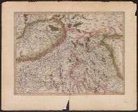
Appears in Mercator's Galliae tabula geographicae ... [Duisburg ca.1595]., Latin text on verso., Page number on verso "163-164"., Relief shown pictorially., Sheet measures 45.5 x 56.2 cm., and Title supplied by Koeman.
Publisher:
Gerardum Mercatorem,
Subject (Geographic):
Basel (Switzerland : Canton)--Maps--Early works to 1800, Switzerland--Maps--Early works to 1800, and Zurich (Switzerland : Canton)--Maps--Early works to 1800