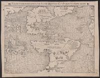
Nouus orbis, qui insulas habet Indici Oceani ... and Tabula novarum insularum, quas diversis respectibus Occidentales & Indianas vocant
Description:
Appears in Münster's Cosmographiae universalis. 1559., Ms. notes on verso. Sheet measures 28.6 x 37.1 cm. Cross Collection no. 109., Relief shown pictorially., and South America also labeled in German.
Publisher:
Sebastian Münster,
Subject (Geographic):
Western Hemisphere--Maps--Early works to 1800
Subject (Name):
Münster, Sebastian, 1489-1552. Cosmographiae universalis and Petri, Heinrich, 1508-1579
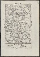
Tabula orientalis regionis, Asiae scilicet extremas complectens terras & regna
Description:
Appears in Münster's Cosmographiae universalis., Includes ill., No. on verso: 12., Relief shown pictorially., Sheet measures 30 x 38 cm. Stamp on verso: Jan 4 1961., and Text on verso: Nova tabula Indiae et totius ferè Asiae cum infinitis insulis, quae in mari Indico ...
Publisher:
H. Petri,
Subject (Geographic):
Asia--Maps--Early works to 1800
Subject (Name):
Münster, Sebastian, 1489-1552. Cosmographei and Petri, Heinrich, 1508-1579
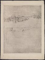
"A facsimile of the original drawing in the Sutherland Collection of topographical pri, "Reproduced by the Typographic Etching Company, for the Topographical Society of London 1881-2.", and Cover title: View of London ab. A.D. 1550, by Antony van den Wyngaerde.
Publisher:
Topographical Society of London,
Subject (Geographic):
London (England)--Aerial views--Early works to 1800--Facsimiles and London (England)--Pictorial works--Early works to 1800--Facsimiles
Appears in the author's Delle navigationi et viaggi., Covers Africa, except for the western bulge and southern tip., Has watermark., Includes text on verso., Oriented with north to the bottom., Pg. no. in upper right margin: 261., Relief shown pictorially., and Titl
Publisher:
G.B. Ramusio,
Subject (Geographic):
Africa--Maps--Early works to 1800
Subject (Name):
Ramusio, Giovanni Battista, 1485-1557. Delle navigationi et viaggi
Qazwīnī, Zakarīyā ibn Muḥammad, 1208 or 9-1283 or 4.
Published / Created:
[15--?]
Call Number:
Arabic MSS 575
Image Count:
2
Resource Type:
Maps, Atlases & Globes
Abstract:
In the center of the map is Mecca; the ocean is located on each side along the outer edge of the sheet with the pillars of the earth in the four corners. Great emphasis is placed on Africa and the Nile river. Other places of interest include: Wasteland where nobody lives, Mountains of the Moon, Land of the Slavs and Franks, Gog and Magog, Land of the Turks (Central Asia), Red Sea (rectangular water mass), the Source of life.
Description:
Gift of Thomas E. Marston, Yale '27, in honor of Alexander O. Vietor, Yale '36, in November 1978., Removed from a bound volume., and Tempera and ink.