Skip to search
Skip to main content
Skip to first result
Search
You Searched For
Date
1500 - 1599
Extent of Digitization
Completely digitized
Genre
Maps
Resource Type
Maps, Atlases & Globes
Date Created
1500 to 1599
New Search
Search Results
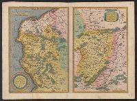
Creator:
Published / Created:
1578
Call Number:
3546 1578
Container / Volume:
BRBL_00113
Image Count:
2
Resource Type:
Maps, Atlases & Globes
Alternative Title:
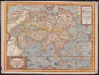
Tabulae geographicae.
Description:
From Tabulae geographicae Cl: Ptolemei ad mentem autoris restitutae & emendate per Gerardum Mercatorem ..., Latin text on verso., and Sheet measures 41.5 x 53 cm.
Publisher:
Typis Godefridi Kempensis, Anno Virgineit partus,
Subject (Geographic):
Armenia--Maps--Early works to 1800 and Asia--Maps--Early works to 1800
Found in:
Beinecke Rare Book and Manuscript Library > Asiae III Tab:.
Creator:
Published / Created:
1575]
Call Number:
50 1575
Container / Volume:
BRBL_00733
Image Count:
1
Resource Type:
Maps, Atlases & Globes
Description:
Appears in the author's Cosmographie universelle., Hand col. Sheet measures 37 x 49 cm. Lanman Collection., Includes ill., text., and Relief shown pictorially.
Publisher:
P. l'Huillier,
Subject (Geographic):
Asia--Maps--Early works to 1800
Subject (Name):
L'Huillier, Pierre and Thevet, André, 1502-1590. Cosmographie universelle
Found in:
Beinecke Rare Book and Manuscript Library > Asie / A. Thevet, cosmographe du Roy.
Published / Created:
[1575?]
Call Number:
41 1575
Container / Volume:
BRBL_00240
Image Count:
1
Resource Type:
Maps, Atlases & Globes
Alternative Title:
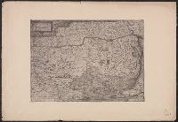
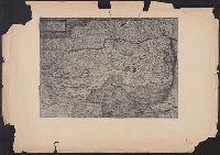
Avstriæ dvcatvs sev Pannoniæ svperioris chorographia
Subject (Geographic):
Austria--Maps--Early works to 1800 and Hungary--Maps--Early works to 1800
Found in:
Beinecke Rare Book and Manuscript Library > Austriæ ducatus seu Pannoniæ superioris chorographia ... / a Wolfgango Lazio.
Published / Created:
[1575?]
Call Number:
41 1575
Container / Volume:
BRBL_00240
Image Count:
1
Resource Type:
Maps, Atlases & Globes
Alternative Title:
Avstriæ dvcatvs sev Pannoniæ svperioris chorographia
Subject (Geographic):
Austria--Maps--Early works to 1800 and Hungary--Maps--Early works to 1800
Found in:
Beinecke Rare Book and Manuscript Library > Austriæ ducatus seu Pannoniæ superioris chorographia ... / a Wolfgango Lazio.
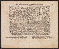
Published / Created:
1549
Call Number:
37 B45 1549
Container / Volume:
BRBL_00150
Image Count:
2
Resource Type:
Maps, Atlases & Globes
Description:
Notes: Above map from another edition is reproduced in Sebastian Münster's Cosmographei, Basel, 1550.
Publisher:
[Sebastian Münster,]
Subject (Geographic):
Bern (Switzerland)--Maps--Early works to 1800
Found in:
Beinecke Rare Book and Manuscript Library > Bern [Switzerland] in der Eydtgenoschafft an dem Wasser Aar gelegen/ figuriert nach ihrer Gelegenheit.
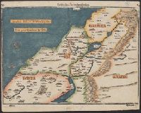
Creator:
Published / Created:
1582?]
Call Number:
51 1582
Container / Volume:
BRBL_00277
Image Count:
2
Resource Type:
Maps, Atlases & Globes
Description:
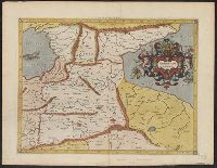
Appears in Bünting's Itinerarium Sacrae Scripturae., In top margin corners: 26 -- 27., Relief shown pictorially., Signature mark on verso: G., and Text on verso.
Publisher:
J. Lucius,
Subject (Geographic):
Palestine--Maps--Early works to 1800
Subject (Name):
Bünting, Heinrich, 1545-1606. Itinerarium Sacrae Scripturae
Found in:
Beinecke Rare Book and Manuscript Library > Beschreibung des Heiligen Landes.
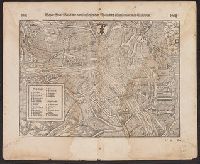
Published / Created:
1549
Call Number:
37 B29 1549
Container / Volume:
BRBL_00150
Image Count:
2
Resource Type:
Maps, Atlases & Globes
Description:
Notes: The above map from another edition is reproduced in Sebastian Münster's [facsimile edition] Cosmographei, Basel, 1550.
Publisher:
[Sebastian Münster,]
Subject (Geographic):
Basel (Switzerland)--Maps--Early works to 1800
Found in:
Beinecke Rare Book and Manuscript Library > Beyde Stett Basel mit dem fürsl. fliessenden Rhein und allen fürnemmen Gebewen.
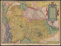
Creator:
Published / Created:
1580?]
Call Number:
335 1580
Container / Volume:
BRBL_00085
Image Count:
1
Resource Type:
Maps, Atlases & Globes
Description:
Below title:"Jacobo a Dauetria auct." and Map digitized.
Publisher:
s .n.,
Subject (Geographic):
Belgium--Maps--Early works to 1800
Found in:
Beinecke Rare Book and Manuscript Library > Brabantiae Germaniae inferioris nobilissimae provinciae descriptio.
Published / Created:
[1581?]
Call Number:
32 B77 1581
Container / Volume:
BRBL_00046
Image Count:
1
Resource Type:
Maps, Atlases & Globes
Alternative Title:
Brightstovve, vulgo; quondam venta, floretissimum Angliae Emporium and Civitates orbis terrarum.
Description:
Mounted on sheet. Annotation on sheet: "Hoefnagel's map of Bristol, 1581 (Braun's Civitates). It shows Broad Stt., where the tennis court stood (1636). Preliminary record.
Subject (Geographic):
Bristol (England)--Maps--Early works to 1800
Found in:
Beinecke Rare Book and Manuscript Library > Brightstowe, vulgo; quondam venta, floretissimum Angliae Emporium.
Published / Created:
[1592]
Call Number:
382 1592
Container / Volume:
BRBL_00175
Image Count:
1
Resource Type:
Maps, Atlases & Globes
Subject (Geographic):
Normandy (France)--Maps--Early works to 1800
Found in:
Beinecke Rare Book and Manuscript Library > Caletensium et Bononiensium ditionis accurata delineatio Veromanduorum Eorumque confinium exactissima descript. Johanne Surhonio Auctore.
Branch:v1.61.8 ,Deployed:2024-06-20T11:14:55-04:00