Search
You Searched For
Search Results
- Published / Created:
- [1780?]
- Call Number:
- 755 1780D
- Container / Volume:
- BRBL_00433
- Image Count:
- 1
- Resource Type:
- Maps, Atlases & Globes
- Found in:
- Beinecke Rare Book and Manuscript Library > Bowles's new pocket map of the middle British Colonies in America, ... habitations and hunting countries of the confederate Indians: by Lewis Evans.
- Published / Created:
- 1781
- Call Number:
- 755 1781A
- Container / Volume:
- BRBL_00433
- Image Count:
- 1
- Resource Type:
- Maps, Atlases & Globes
- Found in:
- Beinecke Rare Book and Manuscript Library > Carte Générale des Colonies Angloises, dans l'Amerique Septentrionale. Par M. Phelippeaux, Ingénr. Géographe ... E. Laysard, Sculp.
- Published / Created:
- 1778
- Call Number:
- 755 1778G
- Container / Volume:
- BRBL_00432
- Image Count:
- 1
- Resource Type:
- Maps, Atlases & Globes
- Found in:
- Beinecke Rare Book and Manuscript Library > Mapa geografica que comprehende la Nueva Inglaterra, Nueva York, Nueva Jersey, Pensilvania, Maryland y parte de Virginia.
- Published / Created:
- 1778
- Call Number:
- 755 1778A
- Container / Volume:
- BRBL_00432
- Image Count:
- 1
- Resource Type:
- Maps, Atlases & Globes
- Found in:
- Beinecke Rare Book and Manuscript Library > Il Canadá, le colonie Inglesi con la Luigiana, Florida di nuova projezione.
- Published / Created:
- 1780
- Call Number:
- 755 1780J
- Container / Volume:
- BRBL_00433
- Image Count:
- 1
- Resource Type:
- Maps, Atlases & Globes
- Found in:
- Beinecke Rare Book and Manuscript Library > Position der Königel; Grossbrittanischen und dem Jerseys in Nord America im Jahr 1780.
- Published / Created:
- 1783
- Call Number:
- 755 1783Q
- Container / Volume:
- BRBL_00434
- Image Count:
- 1
- Resource Type:
- Maps, Atlases & Globes
- Found in:
- Beinecke Rare Book and Manuscript Library > Carte generale des colonies angloises dans l'Amerique septentrionale pour l'Intelligence de la Guerre presente d'apres des manuscrit anglais par J.B. Nolin ... corrigé ... par R. Phelipeau ... 1783.
- Published / Created:
- 1780
- Call Number:
- 755 1780C
- Container / Volume:
- BRBL_00433
- Image Count:
- 1
- Resource Type:
- Maps, Atlases & Globes
- Found in:
- Beinecke Rare Book and Manuscript Library > Carte Nouvelle des possessions Angloises en Amerique ... traduite de l'Anglois d'après Thos. Jefferys, revue et corrigée par M. Moithey ... 1780.
- Published / Created:
- 1784?]
- Call Number:
- 755 1784C
- Container / Volume:
- BRBL_00435
- Image Count:
- 1
- Resource Type:
- Maps, Atlases & Globes
- Found in:
- Beinecke Rare Book and Manuscript Library > Carte Générale des Trieze Etats-Unis indépendants ... d'aprés M. Bonne Ingenieur Hydrographe de la Marine de France.
- Published / Created:
- 1778
- Call Number:
- 755 1778B
- Container / Volume:
- BRBL_00432
- Image Count:
- 1
- Resource Type:
- Maps, Atlases & Globes
- Found in:
- Beinecke Rare Book and Manuscript Library > Carte du Canada et des Etats-Unis de l'Amerique Septentrionale par le Sr. Robert de Vangondy ...
- Published / Created:
- [1780?]
- Call Number:
- 755 1780E
- Container / Volume:
- BRBL_00433
- Image Count:
- 1
- Resource Type:
- Maps, Atlases & Globes
- Found in:
- Beinecke Rare Book and Manuscript Library > Carte des Provinces Sept. les des États-Unis.
- Published / Created:
- 1781?]
- Call Number:
- 755 1781C
- Container / Volume:
- BRBL_00433
- Image Count:
- 1
- Resource Type:
- Maps, Atlases & Globes
- Found in:
- Beinecke Rare Book and Manuscript Library > Map for the Interior Travels through America, delineating the march of the army. T. Conder Sculpsit.
- Published / Created:
- 1783
- Call Number:
- 755 1783P
- Container / Volume:
- BRBL_00434
- Image Count:
- 1
- Resource Type:
- Maps, Atlases & Globes
- Found in:
- Beinecke Rare Book and Manuscript Library > Carte generale des états unis de l'Amerique septentrionale avec les limites de chacun des dits Etats convenus par le traité provisionel du mois de Novembre 1782, par J.B. Eliot.
- Published / Created:
- 1782
- Call Number:
- 755 1782
- Container / Volume:
- BRBL_00433
- Image Count:
- 1
- Resource Type:
- Maps, Atlases & Globes
- Found in:
- Beinecke Rare Book and Manuscript Library > Carte de la Louisiane et du Cours du Mississippi Avec Les Colonies Anglaises.
- Published / Created:
- 1782
- Call Number:
- 755 1782A
- Container / Volume:
- BRBL_00433
- Image Count:
- 1
- Resource Type:
- Maps, Atlases & Globes
- Found in:
- Beinecke Rare Book and Manuscript Library > Carte du Théatre de la Guerre Entre les Anglais et les Américains ... Par M. Brion de las Tour Ingr. Geographe du Roi.
- Published / Created:
- 1783
- Call Number:
- 755 1783M
- Container / Volume:
- BRBL_00434
- Image Count:
- 1
- Resource Type:
- Maps, Atlases & Globes
- Found in:
- Beinecke Rare Book and Manuscript Library > Carte des Etats-Unis D'Amerique, et du Cours du Mississippi ... avec Les Nouvelles Limites Générales fixées par les articles préliminaires de paix ... 1783. Cette carte composée par le Sr. Brion de la Tour, Inq. Géographe du Roi ...
- Published / Created:
- [1780]
- Call Number:
- 755 1780G
- Container / Volume:
- BRBL_00433
- Image Count:
- 1
- Resource Type:
- Maps, Atlases & Globes
- Found in:
- Beinecke Rare Book and Manuscript Library > Partie Meridionale de la Louisiane, avec la Floride, la Caroline, et la Virginie. Par le Sr. D'Anville.
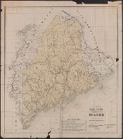
- Published / Created:
- 1786
- Call Number:
- 755 1786
- Container / Volume:
- BRBL_00435
- Image Count:
- 1
- Resource Type:
- Maps, Atlases & Globes
- Found in:
- Beinecke Rare Book and Manuscript Library > A new map of Nova Scotia and Cape Breton Island with the adjacent parts of New England and Canada ...
- Published / Created:
- 1777
- Call Number:
- 755 1777C
- Container / Volume:
- BRBL_00431
- Image Count:
- 1
- Resource Type:
- Maps, Atlases & Globes
- Found in:
- Beinecke Rare Book and Manuscript Library > Theatre de la Guerre en Amérique.
- Creator:
- Le Rouge, Georges-Louis
- Published / Created:
- 1777
- Call Number:
- 755 1777G
- Container / Volume:
- BRBL_00431
- Image Count:
- 1
- Resource Type:
- Maps, Atlases & Globes
- Found in:
- Beinecke Rare Book and Manuscript Library > Theatre de la guerre en Amérique / par le Sr. le Rouge, ingenieur, geographe du Roy.
- Published / Created:
- 1777
- Call Number:
- 755 1777L
- Container / Volume:
- BRBL_00431
- Image Count:
- 1
- Resource Type:
- Maps, Atlases & Globes
- Found in:
- Beinecke Rare Book and Manuscript Library > Carte de l'Amérique Septle. pour fervir à l'intelligence de la Guerre entre les Anglois et les insurgents Dédiée à Mgr de Sartine ... Par M. le Chr. de Beaurain.
- Creator:
- Lotter, Matthäus Albrecht, 1741-1810
- Published / Created:
- 1776?]
- Call Number:
- 755 1778D
- Container / Volume:
- BRBL_00432
- Image Count:
- 1
- Resource Type:
- Maps, Atlases & Globes
- Found in:
- Beinecke Rare Book and Manuscript Library > Carte nouvelle de l'Amérique angloise contenant tout ce que les Anglois possedent sur le continent de l'Amérique septentrionale savoir le Canada : la Nouvelle Ecosse ou Acadie, les treize provinces unies qui font : les quatres colonies de la Nouvelle An
- Published / Created:
- 1777]
- Call Number:
- 755 1777F
- Container / Volume:
- BRBL_00431
- Image Count:
- 1
- Resource Type:
- Maps, Atlases & Globes
- Found in:
- Beinecke Rare Book and Manuscript Library > The British Colonies in North America. Engraved by William Faden.
- Published / Created:
- 1778
- Call Number:
- 755 1778C
- Container / Volume:
- BRBL_00432
- Image Count:
- 1
- Resource Type:
- Maps, Atlases & Globes
- Found in:
- Beinecke Rare Book and Manuscript Library > Carte du Théatre de la Guerre Entre les Anglais et les Américains. Dressée par M. Brion de la Tour ...
- Creator:
- Pownall, Thomas, 1722-1805
- Published / Created:
- March 25th, 1776.
- Call Number:
- 755 1776P
- Container / Volume:
- BRBL_00430
- Image Count:
- 1
- Resource Type:
- Maps, Atlases & Globes
- Found in:
- Beinecke Rare Book and Manuscript Library > A map of the middle British colonies in North America [cartographic material] : First published by Lewis Evans, of Philadelphia, in 1755 ; and since corrected and improved, as also extended, with the addition of New England, and bordering parts of Canada
- Creator:
- Robert Sayer and John Bennett (Firm)
- Call Number:
- 755 1776K
- Container / Volume:
- BRBL_00430
- Image Count:
- 1
- Resource Type:
- Maps, Atlases & Globes
- Found in:
- Beinecke Rare Book and Manuscript Library > A general map of the northern British colonies in America : which comprehends the province of Quebec, the government of Newfoundland, Nova-Scotia, New-England and New-York, from the maps published by the Admiralty and Board of Trade, regulated by the astr
- Published / Created:
- 1777
- Call Number:
- 755 1777A
- Container / Volume:
- BRBL_00431
- Image Count:
- 1
- Resource Type:
- Maps, Atlases & Globes
- Found in:
- Beinecke Rare Book and Manuscript Library > Carte Nouvelle Des Posséssions Angloises en Amérique dressée pour l'intelligence de la guerre présente et divisée suivant les prétentions des Anglois ... Traduite de l'Anglois d'aprés Thos. Gefferys, géographe du prince de Galles.
- Published / Created:
- 1777
- Call Number:
- 755 1777
- Container / Volume:
- BRBL_00431
- Image Count:
- 1
- Resource Type:
- Maps, Atlases & Globes
- Found in:
- Beinecke Rare Book and Manuscript Library > Carte Detaillee Des Possessions Angloises, dans l'Amerique Septentrionale ... E. Laysard, Sculp.
- Published / Created:
- 1776
- Call Number:
- 755 1776J
- Container / Volume:
- BRBL_00430
- Image Count:
- 1
- Resource Type:
- Maps, Atlases & Globes
- Found in:
- Beinecke Rare Book and Manuscript Library > Partie Oriental du Canada, avec la Nouvelle Angleterre, L'Acadie, et la Terre-Neuve. Par le Sr. D'Anville.
- Published / Created:
- 1776
- Call Number:
- 755 1776L
- Container / Volume:
- BRBL_00430
- Image Count:
- 1
- Resource Type:
- Maps, Atlases & Globes
- Found in:
- Beinecke Rare Book and Manuscript Library > A map of the British Empire, in North America. By Samuel Dunn, Mathematician, improved from the surveys of Capt. Carver.
- Published / Created:
- [1832?]
- Call Number:
- 764 B764 1832
- Container / Volume:
- BRBL_00456A
- Image Count:
- 1
- Resource Type:
- Maps, Atlases & Globes
- Found in:
- Beinecke Rare Book and Manuscript Library > Map of Bridgewater, Mass.
- Published / Created:
- 1776
- Call Number:
- 764 B65 1776B
- Container / Volume:
- BRBL_00455
- Image Count:
- 1
- Resource Type:
- Maps, Atlases & Globes
- Found in:
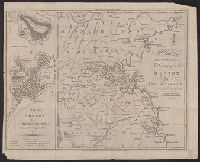
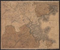
- Beinecke Rare Book and Manuscript Library > An accurate map of the country round Boston in New England ...
- Published / Created:
- 178-?]
- Call Number:
- 764 B65 1774
- Container / Volume:
- BRBL_00454
- Image Count:
- 1
- Resource Type:
- Maps, Atlases & Globes
- Found in:
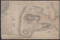
- Beinecke Rare Book and Manuscript Library > A new and accurate plan of the town of Boston in New England ; A new plan of Boston Harbor from an actual survey.
- Published / Created:
- [1781?]
- Call Number:
- 764 B65 1781
- Container / Volume:
- BRBL_00455
- Image Count:
- 1
- Resource Type:
- Maps, Atlases & Globes
- Found in:
- Beinecke Rare Book and Manuscript Library > Baye et port de Boston. Tiré́ des manuscrits de M. le Chevalier de la Rigaudiere ...
- Published / Created:
- 1776
- Call Number:
- 764 B65 1776B
- Container / Volume:
- BRBL_00455
- Image Count:
- 1
- Resource Type:
- Maps, Atlases & Globes
- Found in:
- Beinecke Rare Book and Manuscript Library > An accurate map of the country round Boston in New England ...
- Published / Created:
- 1793
- Call Number:
- 764 B65 1793
- Container / Volume:
- BRBL_00455
- Image Count:
- 1
- Resource Type:
- Maps, Atlases & Globes
- Found in:
- Beinecke Rare Book and Manuscript Library > A plan of the Action at Bunker Hill, on the 17th of June 1775. Between His Majesty's troops, under the command of Major General Howe, and the American Forces: Engraved for Stedman's History of the American War.
- Published / Created:
- 1800
- Call Number:
- 764 B65 1800
- Container / Volume:
- BRBL_00455
- Image Count:
- 1
- Resource Type:
- Maps, Atlases & Globes
- Found in:
- Beinecke Rare Book and Manuscript Library > A new plan of Boston from Actual surveys by Osgood Carleton. With corrections, additions, & improvements.
- Published / Created:
- 1777
- Call Number:
- 764 B65 1777A
- Container / Volume:
- BRBL_00455
- Image Count:
- 1
- Resource Type:
- Maps, Atlases & Globes
- Found in:
- Beinecke Rare Book and Manuscript Library > A plan of the town of Boston, with the intrechments &c. of His Majestys Forces in 1775: from the observations of Lieut. Page of His Majesty's Corps of Engineers: and from the plans of other Gentlemen.
- Published / Created:
- 1814
- Call Number:
- 764 B65 1814
- Container / Volume:
- BRBL_00455
- Image Count:
- 1
- Resource Type:
- Maps, Atlases & Globes
- Found in:
- Beinecke Rare Book and Manuscript Library > Map of Boston in the State of Massachusetts. Surveyed by J.G. Hales Geogr. & surveyor. I.R. Penniman Del. Engraved by T. Wightman Jr.
- Published / Created:
- 1835
- Call Number:
- 764 B65 1835
- Container / Volume:
- BRBL_00455
- Image Count:
- 1
- Resource Type:
- Maps, Atlases & Globes
- Found in:
- Beinecke Rare Book and Manuscript Library > The South Cove territory, comprising every part which is coloured on this map.
- Published / Created:
- 1819
- Call Number:
- 764 B65 1819
- Container / Volume:
- BRBL_00455
- Image Count:
- 1
- Resource Type:
- Maps, Atlases & Globes
- Found in:
- Beinecke Rare Book and Manuscript Library > Map of Boston and its Vicinity by John G. Hales.
- Creator:
- Appalachian Mountain Club
- Published / Created:
- 1890
- Call Number:
- 764 B65 1890A
- Container / Volume:
- BRBL_00456
- Image Count:
- 1
- Resource Type:
- Maps, Atlases & Globes
- Found in:
- Beinecke Rare Book and Manuscript Library > Map of the country about Boston / Geo. S. Harris & Sons, lith.
- Creator:
- E.P. Dutton (Firm)
- Published / Created:
- 1865
- Call Number:
- 764 B65 1865
- Container / Volume:
- BRBL_00455
- Image Count:
- 1
- Resource Type:
- Maps, Atlases & Globes
- Found in:
- Beinecke Rare Book and Manuscript Library > Chart of Boston Harbor and Massachusetts Bay : with map of the adjacent country / published at the Boston Map Store.
- Creator:
- Sampson, Murdock & Co
- Published / Created:
- [1886], c1885.
- Call Number:
- 764 B65 1886
- Container / Volume:
- BRBL_00456
- Image Count:
- 1
- Resource Type:
- Maps, Atlases & Globes
- Found in:
- Beinecke Rare Book and Manuscript Library > Map of Boston for 1886.
- Creator:
- American Association for the Advancement of Science
- Published / Created:
- 1880
- Call Number:
- 764 B65 1880A
- Container / Volume:
- BRBL_00456
- Image Count:
- 1
- Resource Type:
- Maps, Atlases & Globes
- Found in:
- Beinecke Rare Book and Manuscript Library > Map of Boston and vicinity. Prepared for the use of members of the American Association for the Advancement of Science at the Boston meeting, August, 1880.
- Creator:
- Aitken, Robert, 1735-1802
- Published / Created:
- 1775]
- Call Number:
- 764 B65 1775N
- Container / Volume:
- BRBL_00455
- Image Count:
- 1
- Resource Type:
- Maps, Atlases & Globes
- Found in:
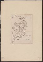
- Beinecke Rare Book and Manuscript Library > A new and correct plan of the town of Boston.
- Published / Created:
- 1775]
- Call Number:
- 764 B65 1775H
- Container / Volume:
- BRBL_00454
- Image Count:
- 1
- Resource Type:
- Maps, Atlases & Globes
- Found in:
- Beinecke Rare Book and Manuscript Library > A plan of the town and chart of the harbour of Boston : exhibiting a view of the islands, castle forts, and entrances into the said harbour.
- Published / Created:
- [1831?]
- Call Number:
- 764 B63 1831
- Container / Volume:
- BRBL_00454
- Image Count:
- 1
- Resource Type:
- Maps, Atlases & Globes
- Found in:
- Beinecke Rare Book and Manuscript Library > A Map of the Town of Bolton in the County of Worcester and the Commonwealth of Massachusetts. Surveyed by Silas Holman in the Year 1831.
- Published / Created:
- 1775?]
- Call Number:
- 764 B65 1775B
- Container / Volume:
- BRBL_00454
- Image Count:
- 1
- Resource Type:
- Maps, Atlases & Globes
- Found in:
- Beinecke Rare Book and Manuscript Library > Sketch of the action on the heights of Charlestown 17 June 1775 between his majestys troops under the command of M. Gnl. Howe and a large body of American rebels.
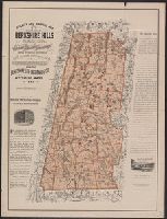
- Creator:
- Watson, Walter, civil engineer
- Published / Created:
- c1883.
- Call Number:
- 764 B45 1883
- Container / Volume:
- BRBL_00454
- Image Count:
- 1
- Resource Type:
- Maps, Atlases & Globes
- Found in:
- Beinecke Rare Book and Manuscript Library > Railway and highway map of the famous Berkshire Hills region, showing also villages and points of interest : from official records and other information / by Walter Watson, C.E. for the Berkshire Life Insurance Co. of Pittsfield, Mass., 1883.