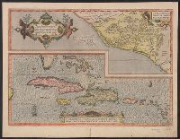
Cvliacanae, Americae regionis, descriptio, Hispaniolae, Cubae, aliarumque Insularum circumiacientium, delineatio, and Hispaniolae, Cvbae, aliarvmqve Insvlarvm circvmiacientivm, delineatio
Description:
Date based on Koeman; however, this state of the map, on which the Tropic of Capricorn appears, is also cited in Koeman as a correction dated 1592/95. and Top map shows modern province of Culiacan in Mexico. Lower map shows the West Indies, Bahamas, southern Florida and eastern Yucatan.
Publisher:
Christophe Plantin,
Subject (Geographic):
Cuba--Maps--Early works to 1800, Culiacán (Sinaloa, Mexico)--Maps--Early works to 1800, and West Indies--Maps--Early works to 1800
Subject (Name):
Ortelius, Abraham, 1527-1598. Theatrum orbis terrarum and Plantin, Christophe, approximately 1520-1589
Cyprus, insula laeta choris, blandorum et mater amorum
Description:
From Ortelius's Theatrum orbis terrarum ... Antuerpiae : Apud Christophorum Plantinum, 1584., Hand col. Sheet measures 22 x 29 cm. Cross Collection no. 102., and Printed in Latin on verso.
Publisher:
Christopher Plantum],
Subject (Geographic):
Cyprus--Maps--Early works to 1800
Subject (Name):
Ortelius, Abraham, 1527-1598. Theatrum orbis terrarum and Plantin, Christophe, approximately 1520-1589, printer
Affbeeldinghe der custen des landts genaempt terra do Natal, item van alle de custen van Coffala, Mozambique, Melinde and Typus orarum maritimarum Guineae, Manicongo, & Angôlae ultra promontorium Bonae Spei.
Description:
Appears in the author's Itinerario, voyage ofte schipvaert van Jan Huygen van Linschoten naer Oost ofte Portugaels Indien., Companion map to Typus orarum maritimarum Guineae, Manicongo, & Angôlae ultra promontorium Bonae Spei ..., and Includes decorative carto
Publisher:
Cornelis Claesz?,
Subject (Geographic):
Africa, Eastern--Maps--Early works to 1800
Subject (Name):
Claesz, Cornelis, approximately 1546-1609, Langren, Arnold Florent van, 1580-1644, and Linschoten, Jan Huygen van, 1563-1611. Itinerario, voyage ofte schipvaert van Jan Huygen van Linschoten naer Oost ofte Portugaels Indien
Subject (Topic):
Coasts--Africa, Eastern--Maps--Early works to 1800
Affbeeldinghe der custen des landts genaempt terra do Natal, item van alle de custen van Coffala, Mozambique, Melinde and Typus orarum maritimarum Guineae, Manicongo, & Angôlae ultra promontorium Bonae Spei.
Description:
Appears in the author's Itinerario, voyage ofte schipvaert van Jan Huyge, Companion map to Typus orarum maritimarum Guineae, Manicongo, & Angôlae ultra promontorium Bonae Spei ..., Has watermark., and Includes decorative cartouche and compass rose and col. ill.
Publisher:
Cornelis Claesz?,
Subject (Geographic):
Africa, Eastern--Maps--Early works to 1800
Subject (Name):
Claesz, Cornelis, approximately 1546-1609, Langren, Arnold Florent van, 1580-1644, and Linschoten, Jan Huygen van, 1563-1611. Itinerario, voyage ofte schipvaert van Jan Huygen van Linschoten naer Oost ofte Portugaels Indien
Subject (Topic):
Coasts--Africa, Eastern--Maps--Early works to 1800
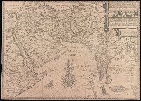
Afbeeldinge der custen van Abex, der engte van Mecha, anders ghenaempt de Roode Zee, Item de custen van Arabien, Ormus, Persen tot Sinde toe and Deliniantur in hac tabula, Orae maritimae Abexiae, freti Mecani ; al. Maris Rubri ; Arabiae, Ormi, Persiae, suprà Sindam usque Fluminis Indi, Cambaiae Indiae et Malabaris, Insulae Ceylon, Choromandeliae, et Orixae, fluvii Gangis, et Regni Bengalae, situs item Sinuum, Insularum
Description:
Backed with paper., From the author's Itinerario, voyage ofte schipvaert van Jan Huygen van Linschoten naer Oost ofte Portugaels Indien., Includes decorative cartouche and compass rose., Relief shown pictorially., and Title in Latin and Dutch. Place names in Latin and Dutch.
Publisher:
[Cornelis Claesz?],
Subject (Geographic):
Africa, Eastern--Maps--Early works to 1800., India--Maps--Early works to 1800., and Iran--Maps--Early works to 1800.
Subject (Name):
Langren, Henricus F. ab (Henricus Florentius), approximately 1574-1648. and Linschoten, Jan Huygen van, 1563-1611. Itinerario, voyage ofte schipvaert van Jan. Huygen van Linschoten naer Oost ofte Portugaels Indien.
Laender Asie nach ihrer Gelegenheit biβ in Indiam, werden in dieser Tafeln verzeichnet
Description:
Appears in the author's Cosmographia., German, Latin., Hand col. Sheet measures 35 x 40 cm. Lanman Collection., Text, ill., "xxiiij" on verso., and Title on verso: India neuw.
Publisher:
H. Petri,
Subject (Geographic):
Asia--Maps--Early works to 1800
Subject (Name):
Münster, Sebastian, 1489-1552. Cosmographia and Petri, Heinrich, 1508-1579
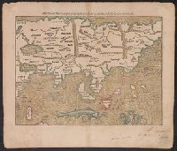
Appears in Bünting's Itinerarium Sacrae Scripturae., In top left margin: 4., In top right margin: 5., Signature mark: ij., and The world is portrayed as a clover leaf.