Aphricae tabula quarta continet Libyam et duas Aethiopias
Description:
Appears in Fries' 1535 Ptolemy., Includes ill., Relief shown pictorially., Sheet measures 40 x 50 cm., Signature mark: I4., Title from caption on verso., and Watermark: Bunch of grapes.
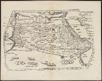
Appears in Fries' 1535 Ptolemy., Covers Morocco and northern Algeria., Includes ill., Relief shown pictorially., Signature mark: II., Text on verso., Title from verso., and Watermark: bunch of grapes.
Publisher:
J. Grüninger?,
Subject (Geographic):
Algeria--Maps--Early works to 1800 and Morocco--Maps--Early works to 1800
Decorated with sea monsters, mermaids, exotic animals, and cannibals, this wood cut map provides a marked contrast to the simplistic diagrams considered the earliest printed world maps. While the latter presented a world view based in Judeo-Christian theo
Alternative Title:
Typus cosmographicus universalis and Typvs cosmographicvs vniversalis
Description:
Appears in Johann Huttich's Novus orbis regionum. Basel. 1532. and Relief shown pictorially.
Publisher:
[publisher not identified],
Subject (Name):
Holbein, Hans, 1497-1543 and Huttich, Johann, 1480?-1544. Novus orbis regionum.
Qazwīnī, Zakarīyā ibn Muḥammad, 1208 or 9-1283 or 4.
Published / Created:
[15--?]
Call Number:
Arabic MSS 575
Image Count:
2
Resource Type:
Maps, Atlases & Globes
Abstract:
In the center of the map is Mecca; the ocean is located on each side along the outer edge of the sheet with the pillars of the earth in the four corners. Great emphasis is placed on Africa and the Nile river. Other places of interest include: Wasteland where nobody lives, Mountains of the Moon, Land of the Slavs and Franks, Gog and Magog, Land of the Turks (Central Asia), Red Sea (rectangular water mass), the Source of life.
Description:
Gift of Thomas E. Marston, Yale '27, in honor of Alexander O. Vietor, Yale '36, in November 1978., Removed from a bound volume., and Tempera and ink.