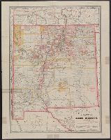
Copyright: Geo. F. Cram., Relief shown by hachures., Shows counties, Indian reservations, land grants, and railroads., and Shows Lincoln and Colfax counties, organized in 1869, but does not show Sierra County, organized in 1884.
Publisher:
s.n.,
Subject (Geographic):
New Mexico--Administrative and political divisions--Maps and New Mexico--Maps
Subject (Name):
Cram, George Franklin, 1841-1928 and Kingman, E., Jr
Subject (Topic):
Indian reservations--New Mexico--Maps, Land grants--New Mexico--Maps, and Railroads--New Mexico--Maps
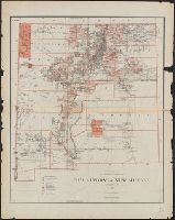
Above title block: J.A. Williamson, Commissioner., Prime meridians: Greenwich and Washington., Relief shown by hachures., and Shows drainage, county boundaries, railroads, railroad grants, private land grants, military and Indian reservations, townships, etc.
Publisher:
General Land Office,
Subject (Geographic):
New Mexico--Administrative and political divisions--Maps and New Mexico--Maps
Subject (Name):
Bien, Julius, 1826-1909 and United States. General Land Office
Subject (Topic):
Indian reservations--New Mexico--Maps, Land grants--New Mexico--Maps, and Railroads--New Mexico--Maps